DJI Mavic, Air and Mini Drones
Friendly, Helpful & Knowledgeable Community
Join Us Now

Drone Panoramas near Yellowstone Park

Dale D

Well-Known Member
Joined
Sep 13, 2018
Messages
6,818
Reactions
7,674
Location
Miami
Site
vimeo.com
These are a combination of panoramas and single shots, taken with the drone at the parking area entering Yellowstone Park I am NOT in the park at this point. You can see the entry sign in one imager.
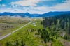
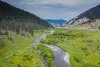
Looking southward, about 20 minutes from the West Yellowstone entrance.; The panoramas are done with stitching images together in Photoshop. Some views are northwards.
I put the Mavic 2 Pro up about 110 feet above my head in plain view. I did 3 to 5 shots, each time overlapping the image on the grid 30%, using photo mode in single shot mode. I uploaded to desk top, into a folder, then opened ACR (Adobe Camera RAW) the 3 to 5 images. Then I selected all. I right clicked, and hit Merge to Panorama. All editing was done after the final image was processed by Photoshop.
 

Attachments

  • GallatinRiver-lookingSouth-Yellowstonlo-rez.jpeg
    GallatinRiver-lookingSouth-Yellowstonlo-rez.jpeg
    486.5 KB · Views: 43
  • GallatinRiver-YellowstonePark-lookingSouth-LoRez.jpeg
    GallatinRiver-YellowstonePark-lookingSouth-LoRez.jpeg
    453.8 KB · Views: 42
  • 7-29-2020-Gallatin-RoadPanorama-LookingNorthLoRez.jpeg
    7-29-2020-Gallatin-RoadPanorama-LookingNorthLoRez.jpeg
    396.7 KB · Views: 38
  • 7-29-2020-GallatinRoad-Pano-LoRez1.jpg
    944.4 KB · Views: 9
As always Dale, nice shots
 
Nice Shots,

Curiosity question, is the no fly line that specific, or in other words, if your just outside the sign a littie ways and you can fly, and of course the app lets you, but walk/drive past the sign or something, you cannot fly, since Yellowstone is a National Park?
 
Nice Shots,

Curiosity question, is the no fly line that specific, or in other words, if your just outside the sign a littie ways and you can fly, and of course the app lets you, but walk/drive past the sign or something, you cannot fly, since Yellowstone is a National Park?
To be absolutely truthful with you, I never even looked at the app. At no time did the drone enter the dividing line into the park. In any case, from this sign to the park entrance is still 25 miles! (e.g.: to the ticket gate) .I put the drone straight up above my head for the shots. I was in the turnout area where people stop to pose for pictures next to the Yellowstone" sign. From our Big Sky condo, this is about a 25 minute drive for me.

A special Yellowstone Fishing License is required if you fish this river, but there is no extra license fee for fishing just north of this sign!
 
I found this additional image for clarification
 

Attachments

  • 7-29-2020-YellowstoneSign-GallatinRoad-Pano-LoRez1.jpg
    943 KB · Views: 9
I see, so you were a modest ways away from the park in a very scenic area... I am sure if you could not take off, you'd be looking as to why.. but since everything was working, you did not worry about it.. I was just wondering how close those lines are drawn. I've read once you're up and if you were closer you can fly over some areas, but probably not a good idea.
 
Please forgive what may be a very silly question but I must ask

Since the M2P takes excellent panoramic photos why takes multiple single shot images and stitch them together in post production
 
Please forgive what may be a very silly question but I must ask

Since the M2P takes excellent panoramic photos why takes multiple single shot images and stitch them together in post production
A very good question, Indeed. I find that the drone panoramas that are generated out of the software of the drone are not as good as the stitched ones. The edges sometime do not match, the colors are off. The JPGs cannot be edited well. The images saves as RAW files can be used and I do that sometimes. I just think that 3 to 5 images overlapped 30% and stitched are better.
 

DJI Drone Deals

New Threads

Forum statistics

Threads
130,586
Messages
1,554,112
Members
159,586
Latest member
DoubleBarS