DJI Mavic, Air and Mini Drones
Friendly, Helpful & Knowledgeable Community
Join Us Now

Finding my property lines/boundaries with my Air 2S?

JustJeff

Well-Known Member
Joined
Apr 30, 2022
Messages
70
Reactions
51
Age
56
Location
Iron River MI
Hey guys and girls. I don't have my drone at the moment. I'm waiting for it to be sent back to me from DJI's refresh program (yikes LOL). I'm pretty much a brand new pilot, and don't have my drone all figured out yet. I've only flown it about ten times before it got wrecked when using the Active Tracking program.

In any event, I bought the house I'm in now late last year. It sits on 40 acres out in the country in the U.P. of MI. We have a copy of the last survey that was done, but there is one property marker missing. As you can see in the picture that I've attached, I know where three of them are at, and I also know that our property is basically a square. Is there a way that I can use my drone (when I get it back on Tuesday) to find and/or mark the last property marker? If I fly the drone from Point "B" to point "C", will my controller tell me how many feet it is between those two points if I take off from, and stand on point "B" with the controller?

I guess this is also a math/geometry question, and it's been too many years since I was in school for me to remember how to find the point where the question mark is. I figured if I can figure out how to find that point with the drone, then I could buy a remote drop kit for it, and drop a red kerchief of something on the spot from the air, and then go plant a stake once I know where the correct spot is. I don't need to find the point for anything "legal" or anything like that, just so that I have an idea of where my property lines are, so that I can cut a UTV trail around my property, so taht my wife and I can ride the perimeter of our property, and not trespass on my neighbor's property.

Any help on figuring out how to do this would be greatly appreciated from this rookie drone pilot. Thank you!Property boundaries.jpg
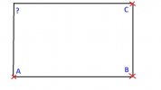
 
It sits on 40 acres out in the country in the U.P. of MI. We have a copy of the last survey that was done, but there is one property marker missing. As you can see in the picture that I've attached, I know where three of them are at, and I also know that our property is basically a square. Is there a way that I can use my drone (when I get it back on Tuesday) to find and/or mark the last property marker? If I fly the drone from Point "B" to point "C", will my controller tell me how many feet it is between those two points if I take off from, and stand on point "B" with the controller?
The drone's GPS is not accurate enough and the points you might get with it could be 10 ft or more out.
A better way if the corner angles are 90°, would be to put markers on poles at A & C and stand near the unknown point with a hand bearing compass and find the spot where you have the correct bearings to A & C.

If the angles aren't 90°, you could still do it with a little more figuring out.
 
  • Like
Reactions: JustJeff
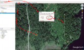
Much easier & accurate to do with a handheld GPS & Google Earth

1.Take the GPS & log the coordinates for A,B & C
2.Use Google Earth & put "pins" at A,B & C on the map
3.Use The Tools/Ruler/Line Measuring & draw a line between B & C to get the heading & distance
4.Draw a line with the same tool from A with the same heading & distance
5.Place a pin (unknown D) where the second drawn line ends
6.Note that pin's coordinates
7.Dial them into the GPS
8.Walk there & put up a new property marker.

(Click on the picture to make it larger)
1654336150263.png
 
  • Like
Reactions: JustJeff
The normal accuracy of standard GPS operation is +- 16 feet 95% of the time whether in a drone or hand held GPS. Of likely to be accurate enough for site planning.
 
  • Like
Reactions: JustJeff
Assuming there is a metal pin at the point, just do a surveyors do. Measure as close as you can from plat diagrams and use a metal detector and some digging. Google maps is your friend when it comes to measuring distances.
 
Thanks guys! I knew how to use the Pythagorean Theorem to "square" things, as I was a union carpenter for 22 years. And in theory, I could figure out exactly where the last point is. But in reality, as a carpenter, I never had to square 40 acres! And I didn't know how to practically and actually place the last marker.
 
Thanks guys! I knew how to use the Pythagorean Theorem to "square" things, as I was a union carpenter for 22 years. And in theory, I could figure out exactly where the last point is. But in reality, as a carpenter, I never had to square 40 acres! And I didn't know how to practically and actually place the last marker.
You really should not place any markers yourself. Thats what registered surveyors are for. That being said if you go to one of your known corner with a good liquid filled hand compass and follow the bearing towards the unknown corner you may find some trees with an old chop mark on them. About waist high or a little higher. Sometimes you will find some old paint on them as well. Often property lines follow fence lines or small ditches as well. Pace out the distance to the lost corner and you might actually find corner witness trees with three marks on them and a pile of rocks, a metal pole, or some other marker for the corner.

In your diagram above you can also run a line from A to ? And then C to ? and where they intersect concentrate your hunt for a corner marker.

I used to do this daily in the forestry business and found corners that hadn’t been seen for decades.

or you can start cutting timber near the lost corner and your neighbors along with the law enforcement they have called will set you right almost immediately. 😂😂😂
 
Last edited:
  • Like
Reactions: JustJeff
Try it! The drone will say the distance from takeoff point.
 
  • Like
Reactions: JustJeff
Any help on figuring out how to do this would be greatly appreciated
First off, my method requires good old fashioned walking about a 1/4 mile from a known marker… I've been to the UP and if your land is as treed as most of the area, then a Drone is going to get sucked into a tree. Besides the fly app does not provide direction in compass degrees and the distance is only a wag (good wag, but still a wag) since you will have to take off from the known boundary location.

Assuming that the missing marker is only notated by the distance and direction from the known markers on your survey, contact the folks who performed the survey and ask them to provide you the GPS coordinates of the unknown marker. Their software will do that in just seconds. Heck, they might even still have your old survey still in the database and the unknown maker's GPS location might even be in the database.

Then using any decent smart device, phone/tablet, go out to the missing marker location with a bought/borrowed/rented metal detector and search for the metal pipe surveyors use to mark property boundaries.

It may cost a few bucks, but trying to do this with a drone will be a lot less frustrating.
 
Last edited:
  • Like
Reactions: JustJeff and FLDave

DJI Drone Deals

New Threads

Forum statistics

Threads
130,585
Messages
1,554,095
Members
159,585
Latest member
maniac2000