We had our first snow of the season last night (very seldom having snow here), so while out walking the dog decided to capture this. Over the rest of the year I intend flying this again in spring, summer and winter with a view to creating a transition video throughout the year. Here's hoping.
You are using an out of date browser. It may not display this or other websites correctly.
You should upgrade or use an alternative browser.
You should upgrade or use an alternative browser.
2 Pro First Snows
- Thread starter scdronemedia
- Start date
If you do a Waypoint 2.0 map you will be able to re-fly and replay the exact same route every time, regardless of the time of the year. Your waypoints will be stored and you can bring them up to fly the route again and again.We had our first snow of the season last night (very seldom having snow here), so while out walking the dog decided to capture this. Over the rest of the year I intend flying this again in spring, summer and winter with a view to creating a transition video throughout the year. Here's hoping.
Dale
Thank you Dale. I have set up a Litchi mission to enable the same flight at each attempt.If you do a Waypoint 2.0 map
Can you educate me a bit about Litchi? (learning curve, cost, etc.) Is it significantly better than Waypoints 2, which I have finally mastered?Thank you Dale. I have set up a Litchi mission to enable the same flight at each attempt.
HI Dale. I would say it is infinitely better and is what DJI should have included. Some balk at the cost which is about $20 but varies when different sales are on. Personally, I tend to use Litchi all the time, in preference to Go4. I have included below a (very) basic workflow e.g. for the above flight.Is it significantly better than Waypoints 2, which I have finally mastered?
Sat on my sofa, open laptop and log in to Litchi site in your browser. You are presented with a google earth map.
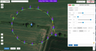
As this is just a small flight, I right clicked to add a POI (in between the two trees) and I believe I set it to 3M above ground.
Added a number of waypoints using left click and then adjusted the height of each (always use 'above ground', especially in hilly areas), the heading of each (in this case all pointing at the POI but you can point the camera in any direction) and gimbal angle and finally the curve size. You can save the mission at any time. Below is a screen shot of what it looks like:

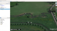
Then I go to a (free) program called 'Virtual Litchi Mission' which presents you with a similar screen and you open the mission. You then click on the blue 'Mission' button and select 'Export as CSV'. This will then open Google Earth on your PC and you can virtually fly the mission, checking heights, camera angles etc. If need be go back to the Litchi site and make adjustments.
Screenshot of a point in a mission in Google Earth - sorry, don't have a screen recorder.

This then gives you a very good idea of the mission. At this point in the mission it is flying sideways (for the completed mission please see 2 Pro - After The Storm (I know it's probably a bit long for you but it gives a very good idea of what it's capable of).
When happy, drive to the location and set the drone up and launch using Litchi. Go to Waypoints, upload the mission to drone and press 'Go'. It gives you the option of which WP to start from, which is very useful if you have a long mission as you can fly it in batches, so keeping within VLOS.
This is a very quick guide to give you an idea of what it does but I'm sure you can find plenty of discussions on this forum. IMHO Litchi far exceeds both DJI Go4 and DJI Fly. It can do everything those apps do and much more and it makes you wonder why DJI do not incorporate. By the way, all the mission planning is done with the drone off and locked away in the case.
@Dale D
Below is a screen video of what you see in Google Earth when you test a mission (except that it is smoother). It gives you a great view of what you have created. You can watch it through at multiple speeds (I speed it up 2/3 of the way through in Google Earth).
The actual video I created is 2 Pro - After The Storm
Similar threads
- Replies
- 1
- Views
- 422
- Replies
- 5
- Views
- 556
- Replies
- 8
- Views
- 1K
- Replies
- 8
- Views
- 780
- Replies
- 14
- Views
- 2K
DJI Drone Deals
New Threads
-
Hiring Remote Drone Pilots and Support Staff with CrewBloom
- Started by felixleo
- Replies: 1
-
3 Along the road to my daughters former school
- Started by alex_markov
- Replies: 1
-
Last Week's Most Popular Topics (December 13, 2025)
- Started by msinger
- Replies: 0
-
Members online
Total: 3,825 (members: 10, guests: 3,815)


