DJI Mavic, Air and Mini Drones
Friendly, Helpful & Knowledgeable Community
Join Us Now

Flight record: difference between "Traval Distance" and "Distance" ?

ylmavicpro

Active Member
Joined
Jun 27, 2018
Messages
40
Reactions
15
Location
CH
Hi, all

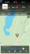
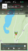
From my last flight I noticed that there are two types of "distance" signs on my flight records "travel distance" and "distance". Actually I was keeping my drone over my stand-point all the time, but the "travel distance" shows 27meters. Does someone can explain that?

Thanks.
 

Attachments

  • Screenshot_20211119-102759.png
    Screenshot_20211119-102759.png
    363.7 KB · Views: 18
  • Screenshot_20211119-102821.png
    Screenshot_20211119-102821.png
    367.6 KB · Views: 18
This is no mystery at all ...

First ...
The distance is ... the distance in a straight line to the recorded HP
The travel distance is ... the total summed up traveled distance

That it can change & sum up even though your drone is stationary right above the HP depends on the accuracy of the civil GPS system. The accuracy is about a 10-33ft radius & it's constantly changing depending on the GPS coverage & the spread of the satellites in the sky.

So looking very close on the map there ... your drone is moving slightly, even though it doesn't in reality. This sums up the traveled distance & may put your drone slightly off the HP.
 
Interesting to know total distance includes vertical ascent and descent.
I’ve just never noticed this in the old Go4 app.
I’m used to gps trackers like Mapout, recording bushwalks, where it measures distance travelled from dead above, it doesn’t take into account topography and extra distance walking up / down hills / valleys.
Nice to have the revelation that buzzing about all over the sky the drone is also adding in the ups / downs to total distance.
 
  • Like
Reactions: slup
Where does that information come from?
I might have misunderstood @slup text above “The travel distance is ... the total summed up traveled distance”, thinking it included vertical travel.
We’ll have to try it I guess.
I anticipated it because of the differences between the 2 screenshot distances / altitudes.
Given the drone has a reasonable altimeter it makes sense that’s a similar travel distance as moving laterally.
That’s different to my mapping/ tracking app that measures ground travel on foot (or other means). That only has top down gps plotting.
It has to be confirmable via the flight analysis data I guess (csv graphing?) ?

Edit - I just noticed slup liked my reply, maybe that lends to the altitude recorded in total travel ?
 
I have just looked at a log from a Mavic 2, I never noticed the "travel" bit until this thread, thanks @ylmavicpro. It started with a vertical climb to something like 17m before it went horizontally. If "travel....." is not prone to lag then it does not record 3d distance, it appears to follow horizontal distance covered.
 
😁 No ... I liked it as I thought you taught me something new.

Well, maybe yes, and maybe not I suppose.

So no one can confirm if only lateral movement is recorded, and the anomaly is only related to the GPS inconsistency ?
Can you see no altitude recorded in total travel (in flight logs) ?

I think it would be easily tested on a flight by any drone, in Fly or Go4 app.
Some fast ascending / descending should be noticeable in the telemetry without any minor gps inconsistency.
 
This is no mystery at all ...

First ...
The distance is ... the distance in a straight line to the recorded HP
The travel distance is ... the total summed up traveled distance

That it can change & sum up even though your drone is stationary right above the HP depends on the accuracy of the civil GPS system. The accuracy is about a 10-33ft radius & it's constantly changing depending on the GPS coverage & the spread of the satellites in the sky.

So looking very close on the map there ... your drone is moving slightly, even though it doesn't in reality. This sums up the traveled distance & may put your drone slightly off the HP.
Thanks you very much for the knowledgable explanation! I always find valuble help for this forum!
 
Two flights just flown
1) mini 2, max height 105m, max distance from home point seen 5m, entry in the profile section reads h = 105m, distance 28m.
2) M2Z, max height 109m, max distance from home point seen 2m, entry in the profile section reads h = 109m, distance 22m
 
  • Like
Reactions: MAvic_South_Oz
Two flights just flown
1) mini 2, max height 105m, max distance from home point seen 5m, entry in the profile section reads h = 105m, distance 28m.
2) M2Z, max height 109m, max distance from home point seen 2m, entry in the profile section reads h = 109m, distance 22m

That's reasonably consistent between the two, and while not obviously recording the generally accurate altitude gain in total distance, the GPS lateral distance is certainly out a fair bit.

I wonder how this differs from land based tracking like the app I use for bushwalks (or 4WD trips) where the GPS is certainly quite accurate on repeated occasion, maybe out by a few metres at most.

I'll check this out when next flying, and might mix up a few things to check consistency over different altitudes and distances, sort of 2 flights one on top of each other . . .
First one to 60m alt and 10m out, then 120m alt and 10m out, see how they differ.
There could be some sort of anomaly there between the two comparisons.

Maybe even try it at near ground level, out to a point some 400m distant, then use the gps on foot to confirm.
Try that same flight with a 5 minute hover at the point on another run.

Will be interesting.
I guess I've just never noticed any irregularity before because normal flight is anything but straight or motionless.
 
Interesting to know total distance includes vertical ascent and descent.
I’ve just never noticed this in the old Go4 app.
It's on my GO4, total distance up down and sideways all add up to total distance flown. It records vertical and horizontal speeds so makes sense that it would record the distance also.
 
It's on my GO4, total distance up down and sideways all add up to total distance flown. It records vertical and horizontal speeds so makes sense that it would record the distance also.

Thanks for the reply, and now I must test next time flying.
I'll be travelling with a GO4 Spark soon, so will try on that.

It's possible GO4 records differently to Fly, if those pilots are not getting altitude changes in total flight distance.
I find it strange I've never really noticed this in nearly 5 years of DJI ownership.

If it is correct, probably because one never really just takes off and doesn't fly up, down, all over the place, easy for altitude travel to get lost amongst the lateral distance.
OK, I just checked one of my flight records and as I ascended (straight up only two feet distance from controller) the flight distance did not go up with my height. It was slowly climbing and when I reached 372 feet it read 49.5 as I hovered there, it continued to climb to 147 feet. Then I started to descend to 220 feet it read 157. It then added as I flew horizontal. So that tells me it is not adding the up and down distance exactly.??? I checked another and when I reached 375 feet it read 33.6 and distance from controller 6.6.
 
OK, I just checked one of my flight records and as I ascended (straight up only two feet distance from controller) the flight distance did not go up with my height. It was slowly climbing and when I reached 372 feet it read 49.5 as I hovered there, it continued to climb to 147 feet. Then I started to descend to 220 feet it read 157. It then added as I flew horizontal. So that tells me it is not adding the up and down distance exactly.??? I checked another and when I reached 375 feet it read 33.6 and distance from controller 6.6.

Odd, maybe just the GPS anomaly as slup suggested.

I'm flat out keeping up with things before going interstate on a work / road trip, so will have ample opportunity to test this with the Spark and Go4.

Thinking about this the other day, my GPS tracking for walks does have the ability to record up / down, it does a profile of walks hills ascents and descents, but doesn't add to the walk total distance covered.
 
OK, I just checked one of my flight records and as I ascended (straight up..........
Could you really zoom in in the map or put the log on Phantomhelp and check if you can see any horizontal drifting whilst the drone is the air. I suspect there is drift both physical wandering around the sky and maybe GPS wanderings (see below).
Thinking about "drift" raises another question, it is often said that GPS is accurate to 'such and such', that makes me wonder if, if the GPS 'location' for a given point drifts does the drone think it has moved and clock up distance??
During the two flights of post #12, it was blustery and when I could see the mini clearly, night flight so it was quickly just a point of light in the sky, it was moving about a bit.
The Mavic 2 was not as troubled, I am adding two and two here to get five, lol.
 
Lycus Tech Mavic Air 3 Case

DJI Drone Deals

New Threads

Forum statistics

Threads
131,645
Messages
1,564,879
Members
160,511
Latest member
Piason