DJI Mavic, Air and Mini Drones
Friendly, Helpful & Knowledgeable Community
Join Us Now

Flight Warning your responsible

I was responding to the fly app that has a rather large rectangle around the local airport. Airplanes cannot fly around in this area below 500 feet and only close into the airport as they are taking off and landing. I wasn.t saying I'm flying my drone inside of this area, but saying if I'm on the beach an airplane cannot fly below 5oo feet over the beach yes they can over the water, I'm not flying my drone over the water and they have to be 1000 horizontal away from the beach. Yes Helicopters you have to watch for everywhere , I was just stating just because there is a heliport at a hospital does not mean you can't fly a drone. I'd like to know the many cases airplanes can legally fly below 500 feet over houses and schools and hospitals other then landing and takeoffs, as this is stated in the FAR's. I am not saying either that the airspace below 400 feet is a drone only airspace, I just showing the many differences in the app's out there being used by drone pilots. I did not mean to imply what you are talking about. You mentioned the B4Ufly is the FAA go to app it has the least info for drone pilots. It only mentions the airport and the Hospital and the common sense of any pilot Situation Awareness.

Sterk03

NOT true at all!

One example is what is called a GO-AROUND. This is where a pilot has an issue on approach and decides to go around to try again. In these cases, it isn't uncommon for the pilot to shift off of the runway and fly along side it to regain speed, reset the aircraft to gain altitude, and then notify traffic he is going back up into the pattern.

And an airplane CAN fly under 500 feet along the beach, road, field where ever. They only need to be clear of buildings and people. I've had lots of fun flying along rivers skimming treetops, for example.

There are also times when something goes wrong on takeoff and a pilot can't climb out as fast as expected. So those extended "wings" on the DJI map cover those cases where and airplane might be flying lower than expected. In emergencies a pilot can pretty much do whatever is needed to keep the airplane flying.

ps: and why is that box so large? Because of a thing called GPS accuracy and map datums. It's been a while, and it'll probably never be activated again, but GPS had something called Selective Availability, a switch the DoD had that intentionally corrupted GPS signals from the satellites to cause incorrect positioning information by as much as several hundred yards. Last time it was on, my boat, tied to my dock, was swinging around inside a 150 foot radius circle as if anchored out in a bay. In reality it hadn't moved a foot.
 
Last edited:
I was responding to the fly app that has a rather large rectangle around the local airport. Airplanes cannot fly around in this area below 500 feet and only close into the airport as they are taking off and landing. I wasn.t saying I'm flying my drone inside of this area, but saying if I'm on the beach an airplane cannot fly below 5oo feet over the beach yes they can over the water, I'm not flying my drone over the water and they have to be 1000 horizontal away from the beach. Yes Helicopters you have to watch for everywhere , I was just stating just because there is a heliport at a hospital does not mean you can't fly a drone. I'd like to know the many cases airplanes can legally fly below 500 feet over houses and schools and hospitals other then landing and takeoffs, as this is stated in the FAR's. I am not saying either that the airspace below 400 feet is a drone only airspace, I just showing the many differences in the app's out there being used by drone pilots. I did not mean to imply what you are talking about. You mentioned the B4Ufly is the FAA go to app it has the least info for drone pilots. It only mentions the airport and the Hospital and the common sense of any pilot Situation Awareness.

Sterk03
First of all you are not being scolded, flamed, jumped on, etc. and we are just trying to make you aware that crewed aircraft will not always be at 500’ AGL or greater even if they should be. Even if they are “too low” you are responsible to give right of way.

First and foremost the app used to give you telemetry of your aircraft DJI Fly does not match up with the flight rules in the USA. It uses the FlySafe database developed by DJI. This is what gives you the warning you see in the app. All you have to do is acknowledge the warning it gives and you can takeoff.

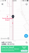
B4UFLY was designed to be as simple as possible to aid recreational fliers in determining if they are allowed to fly in an area. It used to be very useless in its first iterations, but has become a useful app in the last couple of years. Here is a screenshot of B4UFLY for your area that tells you you are safe to fly and reminds you to maintain situational awareness because you have an airport nearby and a heliport both uncontrolled.
0DA0C5E2-07CB-465B-8510-508B998D4299.jpeg

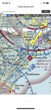
Here is an alternative to using B4UFLY. It is part of a VFR sectional chart. Here you have to determine the airspace you are in, what the weather conditions are before you fly, check for TFR’s and NOTAM’s that may affect the airspace, etc.
C8E977EE-4CE4-4453-AB8A-5FAA9537B04B.jpeg

The B4UFLY app checks this for you and gives you the Clear for Takeoff if everything is good to go. Just as a note of interest you see the red arc on the bottom left of the Sectional screenshot. That is a VIP TFR that is in effect and extends just south of Ocean City. If you bring up B4UFLY and navigate to that area it will give you a red Do Not Fly.

Closing up here, use B4UFLY to check the airspace and then check the Fly app and if needed get your unlocks from FlySafe before you go to fly. There is no need to stress over this. Lastly there are several different apps for checking airspace and some are better than others, but it is a bit like buying a car some like Ford, others Chevy, and still other Chrysler so just a matter of choice.
 
  • Like
Reactions: Faster
I’m the one flying safe I understand the areas better then you think I’m nit the one flying at airports I’m not asking what the warning areas mean or why they exist I’m saying why do I much disparity in the apps where other people can be using those that provide limited information if warnings and they have no aviation background and go flying not understanding them , that’s what I’m asking about not your explanations if clear zones for engine failures. I know how to read a sectional. All I was trying to discuss was why I was getting an enhanced warning for where I was planning to fly within 500 ft horizontal and under 250 ft vertical that is all. That’s why I was giving the different replies I was getting from the drone apps and none of the warnings were applicable to receive an enhanced warning. There were no special airspace or no fly zones or restrictions. I just wanted to know what was triggering this response. Sorry to get everyone in a defensive position. I’m not the one flying and posting videos that clearly break Far’s so no need to warn me about staying away from airports, schools, hospitals, etc.
Thanks
 
I was not locked out I was just trying the DJI
Logic that’s all. I looked at all the charts and asked all the questions and like all others it was agreed upon it was safe and legal. When I started up I got the Enhanced Warning I was just wondering if I missed a Notam?, that’s all! The airport was thought to have caused it but I doubt it as it is always just an advisory and I have been miles away that it would not trigger a EW.
Ok enough

sterk03
 
@Sterk, what @DoomMeister said may need to be repeated. "First of all you are not being scolded, flamed, jumped on, etc."

The folks who responded don't know you or your level of experience and will assume that you might need guidance in basics. Also, this is a group discussion, not everyone is replying directly to you. Your questions strayed away from why you received a warning message, to the differences between UAV apps, to the rationale for regulations.

When you say something like, "Airplanes cannot fly around in this area below 500 feet." you should expect people to respond to what sounds like unfamiliarity with the regulations or misunderstanding. DoomMeister was pointing out that you can't count on them not being there and that even if they're there illegally, you still have to give way.

You began by saying, "Any comments on this situation would be appreciated." I hope you appreciate that everyone who responded was trying to help and trying to resolve the issues being discussed by the group. It's a good group and this discussion provides a lot of useful information to lots of people who read it.
 
I’m the one flying safe I understand the areas better then you think I’m nit the one flying at airports I’m not asking what the warning areas mean or why they exist I’m saying why do I much disparity in the apps where other people can be using those that provide limited information if warnings and they have no aviation background and go flying not understanding them , that’s what I’m asking about not your explanations if clear zones for engine failures. I know how to read a sectional. All I was trying to discuss was why I was getting an enhanced warning for where I was planning to fly within 500 ft horizontal and under 250 ft vertical that is all. That’s why I was giving the different replies I was getting from the drone apps and none of the warnings were applicable to receive an enhanced warning. There were no special airspace or no fly zones or restrictions. I just wanted to know what was triggering this response. Sorry to get everyone in a defensive position. I’m not the one flying and posting videos that clearly break Far’s so no need to warn me about staying away from airports, schools, hospitals, etc.
Thanks
Again I was not getting on to you or suggesting you were flying unsafely. Your responses left some doubt as to your familiarity with airspace. As @MS Coast was saying this is an open forum and the whole internet has access to the posts so we attempt to help educate everyone that visits the forum.

I personally fly near a hospital with an active helipad. Since the pandemic it has gone from one flight every 1 or 2 weeks to an average of 4 to 6 flights per day. The airspace is Class G as is yours, and we are both in an area with Class E starting at 700’ AGL. If I flew a DJI aircraft there I would have to unlock it every time I flew there. All airspace apps say I’m allowed to fly there, but each has its own way of alerting me to the fact there is an active helipad.

Due to the frequency of use at that helipad I have changed the way I fly there. I am even more vigilant to crewed aircraft in the area and seldom fly more than 120’ AGL which is 50’ above the tallest trees and 20’ above the tallest part of a building in that area.
 
So after posting in this forum about flying a drone in Ocean City NJ, yesterday I was ready to takeoff from the beach and I got this warning, and sorry I forget the wording but it said like I was in a warning area or caution zone and I had to acknowledge that I would be responsible before it would let me takeoff. From what I received from the forum and what all 4 before you fly app's said I was perfectly legal to fly. The sectional chart shows no warning area or restrictions, and not aware of any city ordinance. I'm thinking this is another DJI being super safe and trying to control the drone. I have this issue flying at a local park back home where it will not let me takeoff and it's locked out. I am perfectly legal by the apps and Laanc to fly under 100 feet within the controlled airspace but the Drone is locked out. I have not looked at this area of DJI but I believe I need to learn how to get around this limit.
Any comments on this situation would be appreciated. I will be trying another flight and will get a copy of this warning if it pops up again.

Thanks

Sterk03
I live in Erie PA and I have two DJI drones - one uses the DJI Fly app (Mavic Mini) and the other uses the DJI Go4 app (Mavic Air). They disagree with each other. I have often flown the Mavic Air over and around an observation tower on the edge of the bay here - beautiful shots of the bayfront, the tower and the city. Many other drone pilots fly there too. But with the Mini, I cannot take off there because of the airport runway extended - for 5 miles - apparently intersects with the site. No altitude restriction on AirMap. No issues with B4UFLY, but cannot take off. So I use the Mavic Air instead of the Mini.

As to the warning issue, it may be because there is the possibility of helicopter traffic in the area. There is a large hospital near the bayfront and there are frequent flights in and out so you have to maintain situational awareness. I can only remember once having a warning but if you get one, get your drone down immediately.
 
My apologies if I headed the OP question in the wrong direction. But, I was puzzled by his question, so I asked for my own clarification.
At least now I have a better understanding of the apps and the dji nanny. So thanks for the info.
 
I fully understand understand who has the right away and to fly safe and have situation awareness that’s why I was caught off guard getting the warning and that’s why I posted it. I get it that DJI is trying to protect themselves and the flyers from putting their drones in an unsafe position. I am just baffled that the FAA B4UFLY has what appears to have the least info snd situation awareness of all the apps that’s all I was trying to discuss. I think it’s good that AirMap gives you the advisories in case you miss something and inform you that maybe this is not a good location to fly your drone.
Thanks All is good.
Sterk03
 
B4UFLY generally keeps up with NOTAMS and other legal requirements. E.g., it will let you know there's a presidential no fly NOTAM in progress. Again, it is based on rules, but it also adds an occasional info placard like nearby airports and helipads. You may want to try using it for a while before bashing it as inadequate.
 
If you read my text I was doing a comparison of all apps everyone in the group text mentioned. All I said it seems to offer the least amount of info regarding the flight of all others and knowing the FAA for 52 years I find that hard to believe. I never mentioned that the B4UFly does not issue notams. I have been using the app and I also look at the other apps as well and that’s why I I was surprised at the warning and should have realized it had to do with DJI but it was the first time I have experienced it being just as close to an airport and heliport. I’ll end my discussion there.

Thanks again for all the responses .
 
Simple warning that something nearby. Unused heliport next door so I get it every time I fly close by. Click ok, takeoff.
 
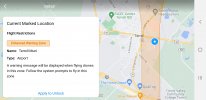
There are lots of "municipal" airports in East TX that are not "Restricted" Airspace:

1648850160826.png
 

DJI Drone Deals

New Threads

Members online

Forum statistics

Threads
134,575
Messages
1,596,443
Members
163,076
Latest member
thelelans
Want to Remove this Ad? Simply login or create a free account