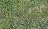
Hi there I am currently using a Mavic 3 Enterprise for forestry ortho mapping and having issues with blur of pine trees
Flying at 120m (highest allowed in NZ under 101) and have played around with changing overlaps and haven't noticed a change in results.
Using WebODM for processing
Interested to hear what other people have been using to get better results, from overlap ratio, elevation settings and ortho mapping software to get better results