DJI Mavic, Air and Mini Drones
Friendly, Helpful & Knowledgeable Community
Join Us Now

Further Coordination Denied with no details

Two points.

If you do get authorization from the FAA to fly, don't forget to also get your authorization from DJI's Geo Fencing. It would be discomforting to have your FAA authorization, be onsite the day of the function, and then your UAS won't take off because of DJI's Geo zoning.

If you are unable to get the authorization, look into the Insta360 X3 camera. You can put it on a 20' pole, you don't have to worry about pointing it to get the shot as it will record everything in all directions. Then you can then edit and get the best scenes and shots even if you were looking the wrong direction. It may not be drone, but it will give the viewers the same effect and it has great quality. Check it out on YouTube.
 
  • Like
Reactions: Torque
Thank you for quick response, I very much appreciate that.

I would really like that as well as you can tell, it is frustrating to receive a denial and have no idea how to proceed.

What would you recommend I use for safety plan? This part has always been somewhat overlooked for much of my flights mostly because my safety preparations are following my checklist, keeping an eye on the operational area to react or identify flight risks, and all that stuff that is basically contained within the 'Be a responsible remote operator" category.

Should I list all those basic precautions or is there something else they are looking for that I should ensure I include?
I have received several waivers to fly in MSP airspace. A few for overflying the VA, and several just south of 494 next to Fort Snelling Park. Best I could do for the VA was 100’, but that was within 200’ of the airport boundary. Vic is correct, MSP ATC is great.
ATC is concerned about SAFETY and mitigation. How can you prevent your drone from being a problem if something goes sideways?
First, ask for a flight radius of 0.1 mile or less. Then limit your altitude to 100’. Tell them what will happen in the event of a lost connection. Think of all the ways you can ensure safety and mitigation. Write them down. They want to know that you know what you are doing.
Good luck.
Then you can start dealing with Geozones. 😩
 
Hello everyone,

Thanks again for the recommendation to add more information to the LAANC request. So I did that, and it was denied again. So this is the frustrating part. I'll add all of the details I can so you can review it and see where I am going wrong here. This is seriously starting to piss me off and it shouldn't.

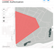
The Flight details in the LAANC was the flight area in image below, where I am only on Ft Snelling airspace, not even crossing the street to the Holiday gas station where most of those attending the event will be rallying. The flight altitude is 200 Ft and the date is May 6th from 9am until 1pm.
1707445006698.png

In the stafety information I state that I will be maintaining strict LOS of the aircraft, will be utilizing geofencing, and setting an auto homing location and provided a Lat Long within my operation area in case there is a disconnect with the controller to prevent a fly away.

I'm freaking stumped and all of this mess is making me not want to fly drones any more. The FAA can win, I don't give a crap, its too much stress to deal with these a-holes sometimes. Any assistance you can provide will be helpful.
 
Well that sucks. A few hours authorization on one day even if the air traffic is landing from the S or SE....I used to park on Post Road and watch aircraft land all day when big Northwest Airlines 747s would come from across the MN river. Maybe don't just give up just yet as you might be missing something else.....maybe bring it down to 50 feet which is the tops of those tall trees or below the tall buildings in the area.
 
Reread my post above, the third paragraph.

Begging your pardon if you have done this already. If not: are you going through the FAA Drone Zone portal (not LAANC) logged in as yourself? Do that, go to your Dashboard, under Part 107 Waivers & Airspace Authorizations, scroll down and click on the blue box saying Create Part 107 Waiver/Authorization. A pop up will enable you to click on Airspace Authorization. Click on start application. Fill in all the requisite information. Hit Next. Tell them again how you will GEOFence your aircraft, the RTH and flight altitude will be set to 100' or less, how much experience you have with this type of operation. State your credentials. Submit your pre-flight checklist (mandatory). Your flight area is too large and 200' is too high for that location. Go with 0.1 mile radius and 100'. Add strobes. Tell them you are using strobes. All the better to see with. Try again.
It has been a couple of years but when I flew the VA, I asked for 200' and they came back with 100', so I think that is their sweet spot. They also asked me to call the tower before the mission and after completion. They may or may not ask for this in the Authorization. I also had to be reachable on my cell phone in the event they called me down (they didn't).
Good luck.
 
  • Like
Reactions: Torque
Don't use LAANC. Use Airspace Authorization on the Drone Zone.
 
  • Like
Reactions: BigAl07 and Torque
I wanted to close the loop on this discussion. I did finally get my authorization, though it was a lot harder than it needed to be given the lack of constructive feedback. So here is what I had to do, thanks to all of you for your suggestions, I am very new at this so it is difficult to get better at something when you have no idea what you are doing wrong.

I used the FAA Drone Zone web portal and selected the area and limited the altitude to 100ft. I described all of the safety control measures such as geofencing, and using a 3NM strobe on top. I also included my preflight checklist and that seemed to be enough for the FAA to grant the authorization.

I have since decided to look into drone-specific log books online and found one that seems to be really good at dronelogbook.com. I loaded my inventory and such in there and will give that a try so I can be more organized with my flights and be accountable for hours on the aircraft, batteries and props.

Thanks for all the help here, I really appreciate it. I would not have considered the things I did without your input.

Good hunting.
 

DJI Drone Deals

New Threads

Forum statistics

Threads
135,463
Messages
1,606,305
Members
163,903
Latest member
saumathur
Want to Remove this Ad? Simply login or create a free account