

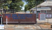
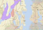
I'm a 107 remote pilot and photojournalist working in Washington State. An interesting observation regarding a sign I noticed during a non-flight photo assignment in tiny Keyport WA unrelated to this Naval Base there (one of multiple restricted base areas in Kitsap County). I noticed a small sign with a drone in a circle and bar -- stating "Warning/Prohibited" -- at the entrance to the base (shown in Google map photo; drone signage is at right). I had never seen a government anti-drone sign before and was curious to know if the drone restriction matched 'unauthorized' airspace on an app or other FAA mapping site. It didn't. I checked KittyHawk and it did not show this airspace over Keyport as restricted. When I got home, I looked at Visualize It, and it also does not show Keyport as restricted airspace on its map (see attached; Keyport is the black dot). Other Department of Defense restricted areas are clearly seen in nearby blocked-out restricted airspace shown in color.
This is a general FYI. Be careful. The signage is very small and threatens prosecution. You'd have to drive right up to it to even see it. In this particular case, some resources we use to fly safe, including apps and maps, do not appear to match military base signage on the ground.
This is a general FYI. Be careful. The signage is very small and threatens prosecution. You'd have to drive right up to it to even see it. In this particular case, some resources we use to fly safe, including apps and maps, do not appear to match military base signage on the ground.


")


