DJI Mavic, Air and Mini Drones
Friendly, Helpful & Knowledgeable Community
Join Us Now

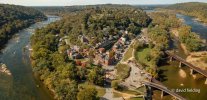
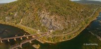
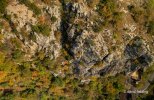
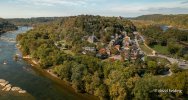
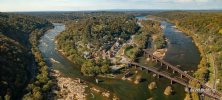
2 Pro Harpers Ferry, West Virginia - Oct. 24, 2021

macfawlty

Well-Known Member
Joined
Nov 4, 2018
Messages
890
Reactions
828
Location
Washington, DC
Still a bit early for autumn colors in Harper's Ferry, but if you were looking for a great place to capture video and photos not far from the Metro DC area, the next couple weeks should see more color. For a legal, safe place to launch in this area surrounded by National Park land, search for my other posts about the old Hilltop Hotel on the bluff overlooking the town.

DJI_0267-0297.jpgDJI_0246-0261.jpgDJI_0300-0318.jpgDJI_0267-0297.jpgDJI_0246-0261.jpgDJI_0300-0318.jpg
 
Last edited:
Do you know by any chance location nearby Shenandoah Park where it's potentially legal to fly the drone?
Well, I think you have to plan out what features you'd like to film/photograph and attempt to locate a place to launch outside of the NP boundaries. The mountains/landforms would be in the background of shots along the Shenandoah River valley, which has a lot of sections worthy of flying over. I'd take a drive along the Shenandoah Valley, find some river access points or paddle along the Shenandoah, which will likely yield some great shots. I may have to do that myself now that you mention it.
 
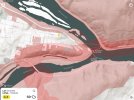
7B2F1DAC-9C01-41CF-924F-03E7FE5B584A.jpegSorry but I’m trying to figure out how you were able to get to the river. I live in Charles town I know Harpers ferry well. I see where you can take off at the hotel but I don’t see how you can fly over to the river. Attached is a picture from Aloft. To me you’re crossing over national park. Am I missing something? I would love to fly there also but it makes me a bit nervous looking at this. Let me know your thoughts.
 
View attachment 137201Sorry but I’m trying to figure out how you were able to get to the river. I live in Charles town I know Harpers ferry well. I see where you can take off at the hotel but I don’t see how you can fly over to the river. Attached is a picture from Aloft. To me you’re crossing over national park. Am I missing something? I would love to fly there also but it makes me a bit nervous looking at this. Let me know your thoughts.
The way I read the rules is you can cross over a national park as long as you have VLOS, you just can't take off inside a park.
 
  • Like
Reactions: IFlyhigh37
Still a bit early for autumn colors in Harper's Ferry, but if you were looking for a great place to capture video and photos not far from the Metro DC area, the next couple weeks should see more color. For a legal, safe place to launch in this area surrounded by National Park land, search for my other posts about the old Hilltop Hotel on the bluff overlooking the town.

View attachment 137161View attachment 137162View attachment 137163View attachment 137161View attachment 137162View attachment 137163
Those are some really beautiful shots!!!

Dale
 
View attachment 137201Sorry but I’m trying to figure out how you were able to get to the river. I live in Charles town I know Harpers ferry well. I see where you can take off at the hotel but I don’t see how you can fly over to the river. Attached is a picture from Aloft. To me you’re crossing over national park. Am I missing something? I would love to fly there also but it makes me a bit nervous looking at this. Let me know your thoughts.

Thanks for your reply. As you can see in your map, the area is definitely surrounded by National Park land, but as Dale mentioned, you can fly over a National Park as long as you don't launch or land there. The abandoned Hilltop Hotel is a great place to launch as it's on a high bluff above the Potomac River and offers a nice high altitude to avoid signal interference. You can also launch from the river if you have a boat or you can fly from the rocky areas in the river (depending on water levels), accessible from 340 on the VA side from the parking area downstream of the town. In this case, the river is NOT in the NP except for the red areas shown on the map.

The Hilltop Hotel is in Bolivar on East Ridge Street. Just take 340 to Union Street. There's always a security guard in a car at the hotel to make sure people don't try to sneak into the dilapidated hotel buildings, but they're friendly and won't bother you at all. There's a couple benches there, but I brought a chair so I wasn't taking up seating for the other folks that come up for the view. There's parking there as well. If you want to visit the town, it's a short(ish) walk from here as parking in or near the town (@ the Amtrak lot) is nearly impossible unless you get there at like, 7:00 a.m. I launched right at the grassy point.

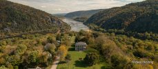
Over the next 2-3 weeks should reveal peak color, so I'll probably revisit. As far as time of day, mid-morning after the sun has come up over the cliffs is good for photos of the town and point, afternoon for photos of the cliffs (Maryland Heights). Here's another view from above Lockwood House down towards the town (approx. 2:30 p.m.) and a video from a previous visit (@ 0:27 you see the flock of ravens swarming around the drone, which made for a really cool scene. Last Sunday there were 3 trains come through while I was there. First two along the East (upstream) bridge, the third along the West bridge (pedestrian bridge) that went along the town and WV side of the Shenandoah (about 2:00, I guess). So, opportunities for train video/photos. I'll post some video clips from this visit later.

DJI_0099-0117.jpg

 
Last edited:
  • Like
Reactions: mreservices
Great photos!
 
Well, I think you have to plan out what features you'd like to film/photograph and attempt to locate a place to launch outside of the NP boundaries. The mountains/landforms would be in the background of shots along the Shenandoah River valley, which has a lot of sections worthy of flying over. I'd take a drive along the Shenandoah Valley, find some river access points or paddle along the Shenandoah, which will likely yield some great shots. I may have to do that myself now that you mention it.
So my idea is to capture the mountains and the foliage , I have seen some pics from Skyline drive from yesterday and it's gorgeous, amazing colors. Now I gotta figure out where to take off from. As far as i remember views are better on the right side of the Skyline Drive southbound. Also I gotta make it as accessible as possible, so no hiking or paddling lol ) i am checking the B4UFLY app for locations take off, there are some points that are greenlighted, but not sure I can actually trust it, tho Let me know if you find a good spot, I am heading there tomorrow.
 
  • Like
Reactions: Texas Propwash
Thanks for your reply. As you can see in your map, the area is definitely surrounded by National Park land, but as Dale mentioned, you can fly over a National Park as long as you don't launch or land there. The abandoned Hilltop Hotel is a great place to launch as it's on a high bluff above the Potomac River and offers a nice high altitude to avoid signal interference. You can also launch from the river if you have a boat or you can fly from the rocky areas in the river (depending on water levels), accessible from 340 on the VA side from the parking area downstream of the town. In this case, the river is NOT in the NP except for the red areas shown on the map.

The Hilltop Hotel is in Bolivar on East Ridge Street. Just take 340 to Union Street. There's always a security guard in a car at the hotel to make sure people don't try to sneak into the dilapidated hotel buildings, but they're friendly and won't bother you at all. There's a couple benches there, but I brought a chair so I wasn't taking up seating for the other folks that come up for the view. There's parking there as well. If you want to visit the town, it's a short(ish) walk from here as parking in or near the town (@ the Amtrak lot) is nearly impossible unless you get there at like, 7:00 a.m. I launched right at the grassy point.

Over the next 2-3 weeks should reveal peak color, so I'll probably revisit. As far as time of day, mid-morning after the sun has come up over the cliffs is good for photos of the town and point, afternoon for photos of the cliffs (Maryland Heights). Here's another view from above Lockwood House down towards the town (approx. 2:30 p.m.) and a video from a previous visit (@ 0:27 you see the flock of ravens swarming around the drone, which made for a really cool scene. Last Sunday there were 3 trains come through while I was there. First two along the East (upstream) bridge, the third along the West bridge (pedestrian bridge) that went along the town and WV side of the Shenandoah (about 2:00, I guess). So, opportunities for train video/photos. I'll post some video clips from this visit later.

View attachment 137264

Thank you for the clarification. I did not realize the rules were about takeoff and not flyover for national parks. That definitely helps. I definitely know the area you’re at. I know that cemetery and I know where the seating area is by the hilltop right next to the flagpole. Actually have had dinner there back when the hotel was still around probably 15 years ago. May have to take a flight there soon especially with the foliage changing. Hopefully the wind has not knocked down too many leaves. Love the pictures. Looking forward to seeing more. How do you like your Mavic 2 Pro? I have an Air 2S but considering the Mavic 3 when it comes out.
 
Thank you for the clarification. I did not realize the rules were about takeoff and not flyover for national parks. That definitely helps. I definitely know the area you’re at. I know that cemetery and I know where the seating area is by the hilltop right next to the flagpole. Actually have had dinner there back when the hotel was still around probably 15 years ago. May have to take a flight there soon especially with the foliage changing. Hopefully the wind has not knocked down too many leaves. Love the pictures. Looking forward to seeing more. How do you like your Mavic 2 Pro? I have an Air 2S but considering the Mavic 3 when it comes out.
I think the leaves are holding on. As you can see in my photos from last weekend it was still pretty green, so I don't think it washed and blew them away. It's pretty nice past peak as well. Some trees turn later and a partial drop exposes some of the rocky ridges. Hopefully, the river will clear up after the storms, but Friday appears to be another day of rain.

I got the M2P in the fall season a few years back when my P3 4k dipped in the water. Didn't want to lose the season while getting a repair. I've loved the M2P over the last few years, but last fall I crashed it in deep woods at Deep Creek Lake and it needed repair. I was going to Seneca Rocks, WV the next weekend, so I was compelled to buy the MA2 or lose the fall season. Made me realize I absolutely MUST have a worthy backup at all times. Towards the end of my visit to Seneca Rocks, I descended the MA2 into the river because I was using the smartphone (first time ever) instead of the tablet (included cable was too short). The tablet is essential for me to be able to read telemetry. I swam/waded into the river, fished it out, rice bagged it and it was fine except for the battery. Wasn't enough time before the trip to buy the wetsuit. This summer, I crashed the MA2 on a small island near the VA side of the Potomac and had to retrieve it with the assistance of a kayak and a bicycle. Despite the crash, it was still fine. Crashed the MA2 again in September flying over Hershey CC, needed minor repair and DJI Drone Service ended up giving me a new one, so that's cool. I didn't have Refresh, but I do have State Farm insurance on both.

I realized retrieval is key, so I now have wetsuits, ArcLightXL, AirTags and Marco Polo. Redundancy.

What I like about the M2P vs. by MA2 is the larger sensor and the lens is not as wide. I can get a little more dramatic effect with motion blur at the bottom of the frame, but that has plusses and minuses. With gimbal down, I have to fly slower or it's all blur. The color science on the MA2 seems a bit odd when color grading, but the normal mode video quality is better than the M2P. The MA2S seems to be a nice camera upgrade that probably resolved some of the issues. The M2P intelligent flight modes aren't as good and I really wish they'd add Spotlight mode in a firmware upgrade, but seems unlikely at this point. I'd consider the MA2S upgrade, but we'll see what happens with the M3. Also would consider the 2nd generation FPV.
 
  • Like
Reactions: mreservices
Lycus Tech Mavic Air 3 Case

DJI Drone Deals

New Threads

Forum statistics

Threads
131,084
Messages
1,559,661
Members
160,067
Latest member
rlafica