

This morning I needed to fly in a 200ft restricted zone to a building on top of a hill. After 'unlocking' the zone, I was surprised to discover that the height limit of 200ft was determined by the take off point, and not by the flight path terrain. This meant that I could not fly up to the building on the hill, even though the top of the hill would be ground level. Is this correct, or am I missing something?
You are using an out of date browser. It may not display this or other websites correctly.
You should upgrade or use an alternative browser.
You should upgrade or use an alternative browser.
Height Limit From Take Off
- Thread starter wildwoodphoto
- Start date

it is because the height AGL is determined by a barometer on the aircraft, that calculates the difference between the air pressure at point of launch and at 200' above that point.
If the pressure was 29.9" at point of take off, the barometer on board is going to stop you at about 29.7" of mercury detected by the on board sensor.
If the pressure was 29.9" at point of take off, the barometer on board is going to stop you at about 29.7" of mercury detected by the on board sensor.
Why from the point of take off, and not during flight? In the example I gave of the hill, by the time the drone got to the hill it was only around 50 ft from ground level but said it was at 197ft. Surely if you’ve set a height of 200ft then it should be 200ft from ground level under the drone at any given time?
StantonZ
Well-Known Member
I don't think you "got" the comment from @neggy: it is because the height AGL is determined by a barometer on the aircraft, that calculates the difference between the air pressure at point of launch and at 200' above that point.Why from the point of take off, and not during flight? In the example I gave of the hill, by the time the drone got to the hill it was only around 50 ft from ground level but said it was at 197ft. Surely if you’ve set a height of 200ft then it should be 200ft from ground level under the drone at any given time?
One way around your problem: land the drone (on the hill) and take-off again...and the calculation resets.
Rich QR
Well-Known Member
One terminology note: AGL is defined as "Above Ground Level", meaning above the ground that is currently below the aircraft.
Our drones have no way to compute their height AGL. They can use their internal barometer to figure out how much their altitude has changed since takeoff, so they use height above takeoff point as a (rather poor) substitute for height AGL.
When you're flying over terrain that's higher or lower than your takeoff point, the drone's displayed altitude is not its current height AGL.
And if the drone is enforcing an altitude limit, it's enforcing it using height over takeoff point, not height AGL, so it's enforcing an incorrect limit, unless the ground you're flying over is at the same level as the ground you took off from. If the limit it's enforcing is one that you set, you can make a manual adjustment, but of course you must estimate the required correction based on the terrain.
I don't like it, but that's the way it is.
AGL is always in reference to TO location. Done that way as barometric pressure varies day to day with the weather. The drone doesn’t know where the ground is after it’s 20’ or so in the air.
Rich QR
Well-Known Member
Not in the FAA rules or sectional charts, it isn't. For example, the sectional legend says that class E airspace exists everywhere from 1200 AGL unless designated otherwise. Surely the FAA doesn't define boundaries between controlled and uncontrolled airspace based on the altitude of the airport where the airplane happened to take off! If so, two airplanes at the exact same altitude could be at different heights AGL, thus in different airspaces, even as they collide in midair!AGL is always in reference to TO location.
And charted tower altitudes are listed in both MSL and AGL, but the AGL altitude doesn't change based on takeoff location.
The height displayed in the DJI Fly app is not AGL, nor is it labelled as AGL. It is just labelled with an "H", and it represents height above takeoff point.
Unfortunately it is true for the drone that To is registered as 0’AGL.... DJI programming does not always follow FAA rules/ergs.., my statement stands and remains undebatably true.Not in the FAA rules or sectional charts, it isn't. For example, the sectional legend says that class E airspace exists everywhere from 1200 AGL unless designated otherwise. Surely the FAA doesn't define boundaries between controlled and uncontrolled airspace based on the altitude of the airport where the airplane happened to take off! If so, two airplanes at the exact same altitude could be at different heights AGL, thus in different airspaces, even as they collide in midair!
And charted tower altitudes are listed in both MSL and AGL, but the AGL altitude doesn't change based on takeoff location.
The height displayed in the DJI Fly app is not AGL, nor is it labelled as AGL. It is just labelled with an "H", and it represents height above takeoff point.
Rich QR
Well-Known Member
Right after takeoff takeoff, sure, while you're still flying over the ground you took off from, you can call the displayed altitude AGL (though DJI does NOT label it is AGL). But as soon as you fly over ground at a different topography, the displayed altitude is no longer your height AGL.
I know DJI doesn't label the altitude displayed in my copy of the DJI fly app as AGL. Have you seen any reference to the contrary? Is there an FAA reference that claims AGL means above takeoff point?
I know DJI doesn't label the altitude displayed in my copy of the DJI fly app as AGL. Have you seen any reference to the contrary? Is there an FAA reference that claims AGL means above takeoff point?
As I said, it is what it is and the terminology use is wel established for drones... most will call it AGL so that reader’s understand.Right after takeoff takeoff, sure, while you're still flying over the ground you took off from, you can call the displayed altitude AGL (though DJI does NOT label it is AGL). But as soon as you fly over ground at a different topography, the displayed altitude is no longer your height AGL.
I know DJI doesn't label the altitude displayed in my copy of the DJI fly app as AGL. Have you seen any reference to the contrary? Is there an FAA reference that claims AGL means above takeoff point?
outa here
So to be clear, in my example, if I ascend to 200ft, fly at that height to the hill and land, I can then re-take off and ascend to a further 200ft, effectively making 400ft in height from the original take off point?I don't think you "got" the comment from @neggy: it is because the height AGL is determined by a barometer on the aircraft, that calculates the difference between the air pressure at point of launch and at 200' above that point.
One way around your problem: land the drone (on the hill) and take-off again...and the calculation resets.
So to be clear, in my example, if I ascend to 200ft, fly at that height to the hill and land, I can then re-take off and ascend to a further 200ft, effectively making 400ft in height from the original take off point?
A bit more information is needed here. Is this "restricted zone" a DJI restricted zone, a LAANC 200 ft grid, or something else? Can you share the location?
The restricted zone is within a LAANC grid (proximity to airfield) for 200ft, and I use the Kittyhawk app for auto-approval in the usual way.
I agree with @sar104 on this one. It would really help to know the location AND is this a recreational or a Part 107 flight.The restricted zone is within a LAANC grid (proximity to airfield) for 200ft, and I use the Kittyhawk app for auto-approval in the usual way.
For recreational flights the UAS Facilities Map altitudes (LAANC grids) are absolute maximum and are measured in feet AGL. Part 107 can ask for variance from those altitudes, but must make the request through the FAADroneZone website portal. That said, it seems odd that a 200 foot grid section would contain a 200 foot hill. If the hill is in a 200 foot grid you can be 200 feet above the top of the hill, but as you move over the slope you also need to lower your altitude to remain within the 200 foot altitude limit.
The way DJI authorizes flight in these areas is flawed in relation to what the rules are by FAA standards.
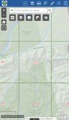
Here’s the map, and it’s for recreational. At the max 200ft limit on the hill, the drone is not above tree level.I agree with @sar104 on this one. It would really help to know the location AND is this a recreational or a Part 107 flight.
For recreational flights the UAS Facilities Map altitudes (LAANC grids) are absolute maximum and are measured in feet AGL. Part 107 can ask for variance from those altitudes, but must make the request through the FAADroneZone website portal. That said, it seems odd that a 200 foot grid section would contain a 200 foot hill. If the hill is in a 200 foot grid you can be 200 feet above the top of the hill, but as you move over the slope you also need to lower your altitude to remain within the 200 foot altitude limit.
The way DJI authorizes flight in these areas is flawed in relation to what the rules are by FAA standards.
Attachments
KB9Radio
Well-Known Member
How would it know the ground level? The pressure changes with altitude (above sea level), and it uses a pressure sensor. You would need to land and then restart again to reset the sensor to the new altitude.Why from the point of take off, and not during flight? In the example I gave of the hill, by the time the drone got to the hill it was only around 50 ft from ground level but said it was at 197ft. Surely if you’ve set a height of 200ft then it should be 200ft from ground level under the drone at any given time?
tlswift58
Well-Known Member
Initial AGL is where the drone took off from - seems to have been next to you. It will then only fly 200 from that point.Why from the point of take off, and not during flight? In the example I gave of the hill, by the time the drone got to the hill it was only around 50 ft from ground level but said it was at 197ft. Surely if you’ve set a height of 200ft then it should be 200ft from ground level under the drone at any given time?
Works that way no matter if restricted or not. If you fly up a hill and it's over 400 ft AGL from where the drone took off from - that is it. Not going any higher at that point.
You need to be at the same AGL as what you will be shooting or relatively close to it from take off.
Here’s the map, and it’s for recreational. At the max 200ft limit on the hill, the drone is not above tree level.
Without knowing exactly where you tried to launch from, or your target, I'll resort to a couple of educated guesses. Here are the relevant DJI Geo zones at that location:

The blue self-authorization zone doesn't know or care about the LAANC grids - LAANC approval to 200 ft is just to be legal. So if you had self-authorized and launched from the blue zone (south of Centaur Rd) then you would not have seen a 200 ft restriction.
However, if you launched from Centaur Rd then you would have been inside the DJI Altitude Zone with a 60 m (197 ft) height limit above your takeoff point. That seems consistent with your account of what happened.
Or, if you started inside the red restricted zone then you would have had to submit your LAANC approval to DJI for a custom unlock, and would have had a 200 ft height limit above takeoff, also consistent.
Assuming that your target was south of Centaur Rd, such as the location below (?) then the solution is simply to launch from further south, outside the DJI Altitude and Restricted zones - then you just self-authorize and will have no height restriction. Of course you still need LAANC approval and to remain below 200 ft AGL to be FAA legal, but that doesn't sound like a problem.

You can fly more than 400 feet higher than your launch point.Works that way no matter if restricted or not. If you fly up a hill and it's over 400 ft AGL from where the drone took off from - that is it. Not going any higher at that point.
Perhaps you don't realise that the default 400 ft limit is user-configurable.
ps. Saying over 400 ft AGL from where the drone took off is very confusing.
The drone is either >400 ft AGL .. or .. it's >400 ft higher than where it was launched
Last edited:
Armillaria
Member
You are right about it. Technically the height shown by the drone would be (in the way it's measured) similar to indicated altitude. To get real AGL, the drone would need to measure it's exact distance from the closest point on the ground (as on a hillside AGL would be it's distance towards the nearest point of the said hillside), so it would need to have some sort of laser sensor and it also would need to be able to determine where is the nearest point on ground located. I guess the solution of this problem would simply make drones unaffordable for most of us. But anyway, the point here is that the height shown by the drone isn't AGL.Right after takeoff takeoff, sure, while you're still flying over the ground you took off from, you can call the displayed altitude AGL (though DJI does NOT label it is AGL). But as soon as you fly over ground at a different topography, the displayed altitude is no longer your height AGL.
I know DJI doesn't label the altitude displayed in my copy of the DJI fly app as AGL. Have you seen any reference to the contrary? Is there an FAA reference that claims AGL means above takeoff point?
Similar threads
- Replies
- 20
- Views
- 3K
- Replies
- 21
- Views
- 6K
- Replies
- 7
- Views
- 1K


DJI Drone Deals
New Threads
-
 2 Pro The Bogomil Cemetery. Celtic Crosses of a Forgotten Christian Sect
- Started by SkylandGreece
- Replies: 0
-
 3 Vitosha under clouds in frost in a cold windy day
- Started by alex_markov
- Replies: 0
-

-
-

Members online
Total: 3,672 (members: 11, guests: 3,661)
Forum statistics
