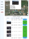
Don't really know what you're doing with this ... together with your pictures, but if you want an overview from both a complete flight & down to individual picture/video filming sessions Airdata.com have a neat view that you might like... this doesn't require a subscription so it's free functionality. This only require you to set up a free Airdata account & in the settings there put in your DJI credentials ... then it only requires you to sync your flights to DJI servers in the GO4 app & they will automatically show up in Airdata.com (you can have 100 logs synced with a free account).
Below from one of my flights where I both shot stills & video ...
View attachment 117312
View attachment 117313
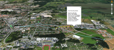
If you download the .KML file from the flight from this Airdata.com view (under the sat pic. above) you get this when it's opened in Google Earth where each point of interest is clickable ... this .KML file can then be saved locally together with your pictures perhaps... or maybe a screen capture from the above view at Airdata.com.
View attachment 117314


