You are using an out of date browser. It may not display this or other websites correctly.
You should upgrade or use an alternative browser.
You should upgrade or use an alternative browser.
If I take off high and go low
- Thread starter Thomas Argo
- Start date
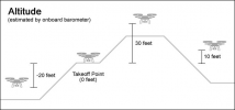
If you fly lower than where you launched, the height displayed on the controller will show the height as a negative number.If I take off from a plateau and go down what happens to the controller readout?
That's the only thing that would make any sense.

H is the approx height above or below the take-off point which is most likely your homepoint. Is it not an altitude reading and is it not a measurement from the drone down to the ground beneath the drone (commonly called AGL).If I take off from a plateau and go down what happens to the controller readout?
BWinef7gb2
- Joined
- Oct 12, 2016
- Messages
- 30,336
- Reactions
- 34,260
- Location
- Harrisburg, PA (US)
- Site
- mavichelp.com
Kuiper Denizen
Well-Known Member
Of course, one has to know the elevation of the plateau and factor in the new above ground altitude to ensure maintaining the 400 ft. limit, adjusting the negative reading accordingly if the ground below continues to drop.
Reverse consideration if going up a slope. I‘ve been 700 feet above my home point while assuring that the elevation over the drone’s existing position is still under 400 feet.
All part of preflight planning, naturally!
Reverse consideration if going up a slope. I‘ve been 700 feet above my home point while assuring that the elevation over the drone’s existing position is still under 400 feet.
All part of preflight planning, naturally!
I know this video is older and some of it may be dated but the piece about shielded operations might be interesting. There is much to be discussed and hashed out but I would hope one day we can visit this idea and make it work in instances you might find yourself in an area where you can safely fly over 400 AGL. I realize there are a ton of factors involved regarding VLOS, etc but the benefits would be amazing considering how safe our drones have become, how long the range (and battery) have become, and the great cameras on our drones. I would be open to getting shielded operations training plus RID to qualify.
That has been talked about in the Part 108 that is coming in the far future.I know this video is older and some of it may be dated but the piece about shielded operations might be interesting. There is much to be discussed and hashed out but I would hope one day we can visit this idea and make it work in instances you might find yourself in an area where you can safely fly over 400 AGL. I realize there are a ton of factors involved regarding VLOS, etc but the benefits would be amazing considering how safe our drones have become, how long the range (and battery) have become, and the great cameras on our drones. I would be open to getting shielded operations training plus RID to qualify.
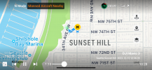
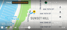
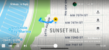
Hi all, just an example from a recent flight log where I was photographing along a cliff edge during a 107 commercial flight. A helicopter could be heard but not seen so I immediately descended under 50'. Attached are screen shots in order. I was over cliff plateau and slightly ventured partly over cliff only after clearing helicopter. The cliff is gradual (w/wooded areas) so I'm sure I remained 400' in uncontrolled airspace in Seattle. The incident rattled me, but my training kept things safe by responding immediately to the helicopter's sound in the distance although I could only generally locate the direction. The sound amplification and doppler effect told me it was fast approaching. Here's a bit of my flight log that day fyi. Weather was severer-clear, almost no wind; excellent flight conditions: << The third flight in north Ballard, SE of Sunset Hill Park, involved a very close call incident, a first for Pilot In Charge (PIC). Upon hearing helicopter, PIC made sudden descent to under 50' -- unseen rapidly approaching helicopter was heard coming loud and fast. The helicopter going south appeared well within 400' uncontrolled airspace and well within sUAS flight path. Mavic 3 sUAS rapid descent from 192' to 47' was taken before visual of helicopter was made. This was within first 90 seconds of flight and safely avoided the possibility of collision. Incident happened along cliffs edge. >> My best theory is that the helicopter was flying over Puget Sound and came up over the cliff at about my flight position; then ascended once over land. I can't be sure. It was moving very fast and disappeared from sight. My advice, use ears before eyes, especially around cliffs where you can't see. Immediately descend, don't wait for a visual. Fly safe.
Attachments
The animation on this is a little troubling since a drone can't do flips without stopping the propellers at a full perpendicular position to the ground. Yikes! And in a safety film!I know this video is older and some of it may be dated but the piece about shielded operations might be interesting. There is much to be discussed and hashed out but I would hope one day we can visit this idea and make it work in instances you might find yourself in an area where you can safely fly over 400 AGL. I realize there are a ton of factors involved regarding VLOS, etc but the benefits would be amazing considering how safe our drones have become, how long the range (and battery) have become, and the great cameras on our drones. I would be open to getting shielded operations training plus RID to qualify.
Similar threads
- Replies
- 13
- Views
- 4K
- Replies
- 5
- Views
- 548
- Replies
- 37
- Views
- 4K
DJI Drone Deals
New Threads
-
-
Air 3 Tales of the Riverbank- Hambleden Weir & Lock
- Started by Pacefast
- Replies: 3
-
-
-


