DJI Mavic, Air and Mini Drones
Friendly, Helpful & Knowledgeable Community
Join Us Now

LAANC request denied

KevinD

Member
Joined
Dec 17, 2016
Messages
19
Reactions
13
Age
59
In controlled airspace where the facility grid states an altitude limit of zero, what has been your experience when requesting manual authorization?

Around Boston as a Part-107 pilot, a LAANC response that denies authorization is typically unclear the reason for denying it. Once upon a time, I did receive a response that suggested the requested altitude was too high and I should aim lower. (I thought that was mostly absurd because the nearby buildings were taller than my requested altitude.) But that's probably the only time I was given a specific reason; since then I just assume the mostly likely reason is altitude.

For a commercial real estate job, the building is 40ft high; my request with ceiling of 100ft was rejected. Seeking to re-submit with a ceiling of 75ft, the Aloft app doesn't have an option between 50ft and 100ft. And 50 is not adequate.

This morning, I submitted another request at 75ft. But the Aloft app does not support that; I can specify 50 or 100, but not 75. To do this, I considered using B4UFly but I expect that to be exactly the same as the Aloft app. I began a request via DroneZone, but that clearly told me to use LAANC instead. So, although Airmap ceased functioning last year, I reinstalled that and it appeared to submit my request successfully.

In addition to the 75ft bit, there possibly might be another reason to use Airmap. When submitting LAANC request via the AirMap app, there's a text box where I can give a bit a brief statement about the flight safety, but the Aloft app does not have that. I have no idea if the FAA sees that or cares about it. (Some may complain about Airmap political wranglings, but achieving authorization is vastly more important.)

What I need is submit a request like this: The property height is X feet tall (or nearby trees are X feet tall) and I am requesting altitude X+50.
 
You best bet is to use the Drone Zone (FAADroneZone) rather than LAANC. Towers don't always keep up to date on their manual LAANC requests, but they do have to look at the Drone Zone Airspace Authorization requests.

KBOS used to be pretty anti-drone, but they've relaxed their stance over the last couple of years.
 
I agree. You'll probably have better luck with DroneZone. However, getting DJI to unlock the space may be a different issue entirely even with FAA authorization. You'll probably have to go through a custom unlock hoop-jump. Make sure you leave enough time to get it all settled.
 
I agree. You'll probably have better luck with DroneZone. However, getting DJI to unlock the space may be a different issue entirely even with FAA authorization. You'll probably have to go through a custom unlock hoop-jump. Make sure you leave enough time to get it all settled.
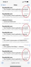
I've done 4 custom unlocks today. Three of them less than 2 miles from the end of the runways at KDEN. The longest one took 6 minutes. DJI is on top of things when it comes to custom unlocks these days.DJIunlocks.jpg
 
I'm glad to hear you had good luck with the unlock. Last year I had an extended project and got authorization from Drone Zone for several days. However, DJI took 4 tries to get it right. Initially, the 500 meter exception I got from FAA was limited to 123 feet. I finally got the right distance fixed with one drone, but the other, in spite of 4 communications with DJI flysafe one drone never did get past the 123 foot limitation in spite of promises and guarantees that it would and had been fixed.
 
In controlled airspace where the facility grid states an altitude limit of zero, what has been your experience when requesting manual authorization?

Around Boston as a Part-107 pilot, a LAANC response that denies authorization is typically unclear the reason for denying it. Once upon a time, I did receive a response that suggested the requested altitude was too high and I should aim lower. (I thought that was mostly absurd because the nearby buildings were taller than my requested altitude.) But that's probably the only time I was given a specific reason; since then I just assume the mostly likely reason is altitude.

For a commercial real estate job, the building is 40ft high; my request with ceiling of 100ft was rejected. Seeking to re-submit with a ceiling of 75ft, the Aloft app doesn't have an option between 50ft and 100ft. And 50 is not adequate.

This morning, I submitted another request at 75ft. But the Aloft app does not support that; I can specify 50 or 100, but not 75. To do this, I considered using B4UFly but I expect that to be exactly the same as the Aloft app. I began a request via DroneZone, but that clearly told me to use LAANC instead. So, although Airmap ceased functioning last year, I reinstalled that and it appeared to submit my request successfully.

In addition to the 75ft bit, there possibly might be another reason to use Airmap. When submitting LAANC request via the AirMap app, there's a text box where I can give a bit a brief statement about the flight safety, but the Aloft app does not have that. I have no idea if the FAA sees that or cares about it. (Some may complain about Airmap political wranglings, but achieving authorization is vastly more important.)

What I need is submit a request like this: The property height is X feet tall (or nearby trees are X feet tall) and I am requesting altitude X+50.
They aren’t going to give you a x+50 authorization, it’s going to be a fixed AGL height. 100ft seems pretty reasonable unless you are tight at the end of a runway. Are you willing to tell the specifics of where this is and maybe we can give you better advice?

I’ve personally had better experience with manual authorizations through LAANC rather than drone zone but I’ve heard the opposite from others. With the drone zone your request goes to an FAA agent in DC and then they make the request to ATC on your behalf. The benefit of that is you the FAA agent might reach out to you if your request seems unlikely to be approved and they’ll give you a chance to amend it. The downside is there’s another layer that it has to go through and can take several days for the FAA agent to submit your request where as with LAANC to goes straight to the airport.

On Drone Zone there is a pop up that says the airport is LAANC enabled and to use LAANC which makes it seem like it won’t let you proceed with the Drone Zone request but you can dismiss that message and proceed with the Drone Zone authorization request.
 
  • Like
Reactions: Vic Moss
I have a wedding in June, but the location is in a Class E surface zone (barely...sigh). LAANC will not approve so I put in a DroneZone request for 75'. I've been to the location and while there is some air traffic it never goes over the location (the closest I saw in the several hours I was there was maybe 1/2 mile away. I don't plan on getting much higher than tree tops (75' at most) so I hope they approve it.
 
I've had pretty good luck with getting a 100' permission in a zero grid around KAUS. The DJI unlock was totally uneventful. This was via DroneZone
 
Last edited:
After authorization denied at altitude=100ft. I resubmitted altitude=75 and that was authorized. But this did require Airmap because Aloft doesn't support any choices between 50 - 100 ft.

And based upon recommendation from Vic and Vindibona1, I used DroneZone to apply for an airspace waiver up to 120ft. This was authorized with modification; the FAA reduced it to 100ft.

Applying for 100 ft with Aloft LAANC, there's no way to add details. Applying via DroneZone, there is allowance for details (where I mentioned that buildings in the area range from 30 to 80 ft tall.)

I also mentioned that I would request a radius of 1000ft, but the online form offers choices of 1/10NM and 1/4NM. The FAA caught that entirely and authorized 0.2 NM (not selectable from the drop-down choices).
 
Lycus Tech Mavic Air 3 Case

DJI Drone Deals

New Threads

Forum statistics

Threads
130,592
Messages
1,554,154
Members
159,593
Latest member
mini2+