Dale, I put this together for a Facebook inquiry. Try it out if your interested.
Here’s my condensed workflow.
- Find a black and white clip art image that you like and take a screenshot of it and crop it close. Save to photos. START WITH SOMETHING SIMPLE!
- Use this online app to convert the the photo to an SVG file.
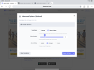
PNG to SVG - FreeConvert.com. Use the settings in the photo attached.
View attachment 182093
- Go to https://www.litchiutilities.com/ and convert the generated file from an SVG file to a Litchi Waypoint Mission. To make it a bit easier use gps coordinates from where you plan to fly the mission.
- Import the generated file into Litchi Mission Hub and see if that’s what you want. You can move it around and resize it but don’t use the rotate feature at this point.
- Save it as a Litchi Mission and name it but end the name with “Flat” as to not mix up the files. Then export as a CSV file.
- Run the file through the “Remove Close Waypoints “ utility on the Litchi Mission Utilitiessite and save it.
- Run that file through the “Litchi Mission Rotator” utility.
- Import that file back into the Mission Hub. At this point you can move it around and rotate it so it faces the camera location you’ve chosen. Save the mission.
A couple of notes at this point:
All the utilities on this site
https://www.litchiutilities.com/ were designed by Wes Barris and without his knowledge and great effort it would not be possible to accomplish this. Please acknowledge him and his website.
Each utility at
https://www.litchiutilities.com/ has an extensive explanation of how it works and options you can choose. READ THEM CAREFULLY!
All my missions are between 200 & 250 meters from the take off location and the minimum distance above ground level is 15 meters. This is relative to the launch location.
For my setup the light on the drone faces backwards so the drone always faces away from the camera unless I want it to turn away so as not to leave light trails between segments.
At the first and last waypoints I set the mission to pause for 10 seconds to give me time to open and close the shutter at the appropriate times.
- At this point the mission can be run using Litchi or Litchi Pilot depending on your drone. If you are using the Mini 4 Pro, the Air 3 series or the Mavic 3 series you will have to convert the file to a DJI Waypoint Mission using the utility on Litchi Mission Utilities. Then import it to your controller (DJI RC 1 or 2, DJI RC Pro or phone)
Final Notes.
Be careful and make sure you are comfortable with every step in the process. You are responsible for your drone and where it flies.
I recommend starting with a very basic image and setting it up to fly over an open field to make sure that it runs smoothly.
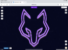
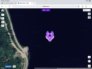
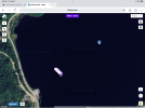
These are a couple of screenshots of what the missions look like in Litchi Mission Hub.
View attachment 182095
View attachment 182096
View attachment 182094
Please keep in mind these missions are risky and you’re doing them at your own risk. It took me a while to get it right with lots of trial and error.


