DJI Mavic, Air and Mini Drones
Friendly, Helpful & Knowledgeable Community
Join Us Now

Lineal Litchi Plan (lots of curves and elevation changes

BigAl07

Administrator
Staff Member
Premium Pilot
Joined
Jun 1, 2017
Messages
6,822
Reactions
15,361
Age
53
Location
Western NC, USA
I've been hired to document a small residential road inside a subdivision for ongoing projects. We need to create the Base Line status of the road so any future damage will be well documented. The problems are:

Narrow Road
Need full width of road and 6' more in the frame and no more (high detail)
Road is curvy
Lots of elevation changes (up and down)
A Few trees come into play with a couple limbs handing out over the road

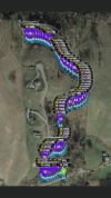
I finally decided to use Litchi to do this and below is a picture of the flight planning (86 different waypoints)
IMG_4795.PNG
 
  • Like
Reactions: MavicAir2Marc
Looks good! Good luck!
 
  • Like
Reactions: BigAl07
Be careful of going low over depressions, watercourses in case the road construction involves culverts or bridges which may impact future flights.
 
I've been hired to document a small residential road inside a subdivision for ongoing projects. We need to create the Base Line status of the road so any future damage will be well documented. The problems are:

Narrow Road
Need full width of road and 6' more in the frame and no more (high detail)
Road is curvy
Lots of elevation changes (up and down)
A Few trees come into play with a couple limbs handing out over the road

I finally decided to use Litchi to do this and below is a picture of the flight planning (86 different waypoints)
View attachment 131670
I use Dronelink to survey irrigation channels and they twist and turn just like your narrow road. Often in each 20 min flight there can be 80+ waypoints and it works fine. I use Agisoft Metashape to convert the 1000+ images into an ortho-photo-mosaic then process this with a satellite application from the European Space Agency. Works perfectly.
Neville
Queensland
Australia ...went to uni in Greensboro NC in 2014 as an exchange student.
 
Don't make this any harder to do than it has to be. I was doing about the same thing, I mounted my drone to the top of my truck and drove it through. Works great!
That doesn't give the level of coverage the HOA needs. They have already attempted a vehicle mounted camera on a pole and it wasn't feasible. Trees, Powerlines etc pose a very real problem.
 
Why did you choose this method instead of just doing a dronedeploy or other mapping software and get a high res ortho map?

The client refused a High Res map. Their needs are for a video from a very specific height. I chose this method because it's the only way I can create the product the client asked for. Appreciate the advice :)
 
Lycus Tech Mavic Air 3 Case

DJI Drone Deals

New Threads

Forum statistics

Threads
130,599
Messages
1,554,240
Members
159,603
Latest member
refrigasketscanada