DJI Mavic, Air and Mini Drones
Friendly, Helpful & Knowledgeable Community
Join Us Now

Litchi or Flight Plan with the Mini 2?

graywoulf

Active Member
Joined
Apr 29, 2022
Messages
32
Reactions
33
Age
68
Location
Wilkes County, North Carolina
Just a premature question as my Mini 2 has not arrived yet. I bought Litchi quite a while back but never used it with my Spark. I was just installing the DJI Fly app on my iPad Mini 4 and I noticed the Flight Plan app for DJI Drones so I am wondering if the latter is any better or easier to use than Litchi.

I feel like I could use one of these with more confidence with the Mini 2 whenever I get around to flying it. I will be moving some time later this month to a different city and would like to scope out the new neighborhood when I get a chance.

Thanks in advance for any input and suggestions.
 
I use Litchi, and it seems great except the jerky yaw in newer drones (including mini 2). But that's a limitation in DJI SDK, it will happen in any app, it is because DJI removed Waypoints from the firmware and now app devs like Litchi's developers need to simulate the behavior, and it's not great...
I made a request about it on DJI Forum, but DJI will not listen: DJI - PLEASE Add REAL WAYPOINTS to Air 2/2S & Mavic 3
Actually, it is a bug in the gimbal control during Virtual Stick operations. A smart engineer reverse-engineered the relevant part of the SDK, and was able to fix the problem by accessing the SDK in an unsupported way, putting the gimbal in the right mode.

IOW, this can be fixed without having uploaded waypoints. DJI just won't do it for some reason.

If I were Litchi et. al., I'd be mad as hell, screaming bloody murder. A huge part of their market is being lost because of this.
 
I wasn't very familiar with Flight Plan until you brought it up here. So I looked it up and now can speak to your question.

Without a doubt, unless you're doing "mapping" I would strongly suggest Litchi as the choice. It has been around for awhile and has SO many features for a $25 app. Litchi, for the most part, can do most of what Go4 of the DJI Fly app can do and is a reasonable substitute if you like it. Yeah, Litchi more expensive than Flight Plan, but worth every penny. I'm going to skip over the obvious features such as creating a waypoint mission on your phone or tablet.

1) Litchi allows you to plan and virtually fly automated missions planned out on your computer for the comfort of your computer chair. It gives you the opportunity to see what you're programmed, fly it on the computer and tweak it before you actually go out to fly. Their "mission hub" where you program your mission also has thousands of missions you can look at and use or modify for your own- from all over the world. That should blow your mind in and of itself. Of course you can program waypoints on site on your tablet or phone, but the computer mission programming is something else. [see bottom photos]

2) FPV capability with inexpensive VR goggles! You can fly FPV and be immersed in flight with a $20 pair of VR goggles. While you legally need to have another person to be a visual observer when you do this, it is a real kick. For me flying VR through and around stuff is a totally different experience than watching my phone or tablet.

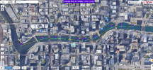
Below is a screen shot of a planned mission that I have not yet flown. Below (or beside) that on is a screen shot of my computer illustrating part of what I'm seeing "in virtual flight". All other features aside, I think this illustrates one of the great Litchi features.

Now, if you like this and you have a good handle on programming, another program to look at is Drone Link. It has the pre-programming features of Litchi, but doing so is far more technical, but can be tweaked to a finer degree relative to where the camera is pointed as well as stopping and stopping filming. I've got it, but it's been over my head. Just thought I'd throw that other option out there. I'm not familiar with DroneLink's other features. I'm not sure if it supports the Mini 2 yet.

That's all I got for now. Good luck.

1651432555060.png

1651432810900.png
 
@vindibona1, After I made this post I did some research on Flight Plan and saw the basics of it which as you say, if I am into mapping, which I am not then it is not going to work for me at all.

Once I get familiar with the Mini 2 and after I move, I will try Litchi out with the Mini 2. Thanks for all of your information and input on the two apps. I also fly FPV with my mostly home built quadcopters and yes, it is a lot of fun. I do have a pair of the $20 VR goggles so I will look into flying the Mini 2 via FPV in the future. Thanks for the info on that. 👍
 
I wasn't very familiar with Flight Plan until you brought it up here. So I looked it up and now can speak to your question.

Without a doubt, unless you're doing "mapping" I would strongly suggest Litchi as the choice. It has been around for awhile and has SO many features for a $25 app. Litchi, for the most part, can do most of what Go4 of the DJI Fly app can do and is a reasonable substitute if you like it. Yeah, Litchi more expensive than Flight Plan, but worth every penny. I'm going to skip over the obvious features such as creating a waypoint mission on your phone or tablet.

1) Litchi allows you to plan and virtually fly automated missions planned out on your computer for the comfort of your computer chair. It gives you the opportunity to see what you're programmed, fly it on the computer and tweak it before you actually go out to fly. Their "mission hub" where you program your mission also has thousands of missions you can look at and use or modify for your own- from all over the world. That should blow your mind in and of itself. Of course you can program waypoints on site on your tablet or phone, but the computer mission programming is something else. [see bottom photos]

2) FPV capability with inexpensive VR goggles! You can fly FPV and be immersed in flight with a $20 pair of VR goggles. While you legally need to have another person to be a visual observer when you do this, it is a real kick. For me flying VR through and around stuff is a totally different experience than watching my phone or tablet.

Below is a screen shot of a planned mission that I have not yet flown. Below (or beside) that on is a screen shot of my computer illustrating part of what I'm seeing "in virtual flight". All other features aside, I think this illustrates one of the great Litchi features.

Now, if you like this and you have a good handle on programming, another program to look at is Drone Link. It has the pre-programming features of Litchi, but doing so is far more technical, but can be tweaked to a finer degree relative to where the camera is pointed as well as stopping and stopping filming. I've got it, but it's been over my head. Just thought I'd throw that other option out there. I'm not familiar with DroneLink's other features. I'm not sure if it supports the Mini 2 yet.

That's all I got for now. Good luck.

View attachment 147591

View attachment 147592
But, here's the hangup. And I've used Litchi since 2017 or so with my Phantom 4 Pro+. With Litchi and the Air 2S, and a waypoint flight, once the drone loses connection with the controller, it will Return To Home as it flies by Virtual Mission. So right now, it's pretty pointless to plan out a long mission
 
But, here's the hangup. And I've used Litchi since 2017 or so with my Phantom 4 Pro+. With Litchi and the Air 2S, and a waypoint flight, once the drone loses connection with the controller, it will Return To Home as it flies by Virtual Mission. So right now, it's pretty pointless to plan out a long mission
Then I guess the solution is to be diligent not to over-extend the mission to the point where the RC loses contact. If you're having issues with that the solution seems to be programming it in smaller sections. If it's that long of a mission, how do you keep it in VLOS?
 
  • Like
Reactions: graywoulf
Then I guess the solution is to be diligent not to over-extend the mission to the point where the RC loses contact. If you're having issues with that the solution seems to be programming it in smaller sections. If it's that long of a mission, how do you keep it in VLOS?
If you keep it in VLOS, there's no sense in planning any mission. Here's a mission I did using my Phantom 4 Pro+ several years ago. The flight took the drone behind the mountain and I lost signal/video for a couple of minutes. All autonomously, and mostly out of VLOS
 
I look at it as a way to pre plan a movie. Programming all the moves and course ahead of time in hopes of getting some smoother shots along the way. I have no intentions of doing any long range missions using Litchi.

As someone once told me a while back, "I don't fly any farther than I am willing to walk to retrieve a crashed aircraft". 😊
You might like to download Virtual Litchi Mission. It works with Mission Hub. Preplan the flight however long you want, and you can export it to Google Earth, than you can fly the mission seeing kinda what you'd see in actual flight
 
You might like to download Virtual Litchi Mission. It works with Mission Hub. Preplan the flight however long you want, and you can export it to Google Earth, than you can fly the mission seeing kinda what you'd see in actual flight
Thanks for reminding me of that feature. I had tried it once with a Spark mission and it was very interesting to see how the mission was going to look like in advance. I will definitely be giving that a shot. 👍
 
If you keep it in VLOS, there's no sense in planning any mission. Here's a mission I did using my Phantom 4 Pro+ several years ago. The flight took the drone behind the mountain and I lost signal/video for a couple of minutes. All autonomously, and mostly out of VLOS
While watching the video, I was trying to figure out when the loss of signal occurred. Was it right at the end of the video when the erratic movements occurred? Did your P4P+ go into an auto return to home at that point?
 
IMHO Litchi is the best tool for drones since the lithium battery. I have used it multiple times and really love the Litchi Virtual Mission feature available to use in Google Earth Pro. I use it to adjust camera angles, camera motion between waypoints (M2, MPro and I 2, x4s). It creates smoother transitions than your thumb ever will.
The mission is loaded into the aircraft, so momentary loss of signal will not cause your mission to fail. However, if you have no connection at the moment you need to abort the mission, that is a problem.
 
Lycus Tech Mavic Air 3 Case

DJI Drone Deals

New Threads

Forum statistics

Threads
131,084
Messages
1,559,668
Members
160,067
Latest member
rlafica