

Does anyone know the reason(s) why an MA2 would suddenly disconnect from the controller? I’ve flown this drone for over a year and a half and it has been almost trouble free. I live in the Rocky Mountains, and all my 46 flights have taken off between 8,500 and 10,300 feet. I’ve flown in snow (with a wet suit) and cold, down to 15F, no problems. On this flight takeoff was normal from 10,110 feet. No unusual terrain, no buildings of any kind. Surface temperature reading was 34F on a bright and sunny afternoon. Landscape was covered in 2-3 feet of snow. It did not quite reach its prescribed altitude of 279 feet before I got the message it had disconnected. I’ve lost contact with it briefly before, but never before received a message that it has “disconnected.” After about 15 minutes, thinking maybe it had landed, I attempted to takeoff, and received confirmation it was now doing so. I pressed the RTH button, got the usual verbal confirmation. Video was now working. Then I got a rather garbled message that this was not a suitable place to land, but nothing happened when I tried to increase altitude. Video showed its descent into some tree branches and then an obvious crash. I tried to activate Find My Drone and got a message I needed wireless connectivity. Went home briefly and connected. The system indicated the drone was located about 200 feet away from the takeoff pad, which seemed odd. I had a spotter with me and we searched thoroughly. The information on the log differed. It indicated the drone traveled 2,368 feet on the first flight at 282 ft, but only 137 feet on the second flight at 88 feet altitude. If as I suspect it traveled down the mountain, 88 feet altitude would have put it into the treetops pretty quickly as it started up. RTH altitude was set at 390 feet. I use an iPad 5 connected with an Anker cable. Firmware for controller updated the night before this flight. I wonder why all of a sudden the drone disconnected. I still qualify for FlyAway assistance. Any ideas will be much appreciated.

You are using an out of date browser. It may not display this or other websites correctly.
You should upgrade or use an alternative browser.
You should upgrade or use an alternative browser.
Loss of Connection, Why ?
- Thread starter oshamtn
- Start date
bravezoo63
Well-Known Member
Does anyone know the reason(s) why an MA2 would suddenly disconnect from the controller? I’ve flown this drone for over a year and a half and it has been almost trouble free. I live in the Rocky Mountains, and all my 46 flights have taken off between 8,500 and 10,300 feet. I’ve flown in snow (with a wet suit) and cold, down to 15F, no problems. On this flight takeoff was normal from 10,110 feet. No unusual terrain, no buildings of any kind. Surface temperature reading was 34F on a bright and sunny afternoon. Landscape was covered in 2-3 feet of snow. It did not quite reach its prescribed altitude of 279 feet before I got the message it had disconnected. I’ve lost contact with it briefly before, but never before received a message that it has “disconnected.” After about 15 minutes, thinking maybe it had landed, I attempted to takeoff, and received confirmation it was now doing so. I pressed the RTH button, got the usual verbal confirmation. Video was now working. Then I got a rather garbled message that this was not a suitable place to land, but nothing happened when I tried to increase altitude. Video showed its descent into some tree branches and then an obvious crash. I tried to activate Find My Drone and got a message I needed wireless connectivity. Went home briefly and connected. The system indicated the drone was located about 200 feet away from the takeoff pad, which seemed odd. I had a spotter with me and we searched thoroughly. The information on the log differed. It indicated the drone traveled 2,368 feet on the first flight at 282 ft, but only 137 feet on the second flight at 88 feet altitude. If as I suspect it traveled down the mountain, 88 feet altitude would have put it into the treetops pretty quickly as it started up. RTH altitude was set at 390 feet. I use an iPad 5 connected with an Anker cable. Firmware for controller updated the night before this flight. I wonder why all of a sudden the drone disconnected. I still qualify for FlyAway assistance. Any ideas will be much appreciated.
bravezoo63
Well-Known Member
So sorry for your loss. I also had an uncharacteristic loss of signal between controller and my MA2 yesterday. The drone initiated it's normal failsafe RTH while I was rebooting the controller. The MA2 reconnected when the controller came back on and I terminated RTH. Several subsequent flights have been fine. Like you, I had just updated to firmware to the most recent version. I don't know if that was a factor, but will be extra cautious for a while.
Can you upload the flying log to be analyzed?
 mavicpilots.com
Mavic Flight Log Retrieval and Analysis Guide
With the introduction of the Mavic Mini there has been a noticeable uptick in the number of posts requesting help with lost or crashed aircraft. While there is plenty of help and advice available on this forum, and detailed guidance and options on several other websites, I thought that perhaps a...
mavicpilots.com
I also had an issue with my MA2 on a recent flight after the recent upgrade. I was descending from filming an open building lot when the screen froze. I was at 350ft and it was about 10deg with a 15mph wind. All of the other controls worked so I was able to land. Once back in the car and warmed up, I shut down the app and restarted the Tripltek 8 Pro. I opened up the app and everything was working again. This was my second flight using the Tripltek so I’m not sure if it was the tablet, the app or the weather. I’ll fly again today and see if it happens again.
Does anyone know the reason(s) why an MA2 would suddenly disconnect from the controller? I’ve flown this drone for over a year and a half and it has been almost trouble free. I live in the Rocky Mountains, and all my 46 flights have taken off between 8,500 and 10,300 feet. I’ve flown in snow (with a wet suit) and cold, down to 15F, no problems. On this flight takeoff was normal from 10,110 feet. No unusual terrain, no buildings of any kind. Surface temperature reading was 34F on a bright and sunny afternoon. Landscape was covered in 2-3 feet of snow. It did not quite reach its prescribed altitude of 279 feet before I got the message it had disconnected. I’ve lost contact with it briefly before, but never before received a message that it has “disconnected.” After about 15 minutes, thinking maybe it had landed, I attempted to takeoff, and received confirmation it was now doing so. I pressed the RTH button, got the usual verbal confirmation. Video was now working. Then I got a rather garbled message that this was not a suitable place to land, but nothing happened when I tried to increase altitude. Video showed its descent into some tree branches and then an obvious crash. I tried to activate Find My Drone and got a message I needed wireless connectivity. Went home briefly and connected. The system indicated the drone was located about 200 feet away from the takeoff pad, which seemed odd. I had a spotter with me and we searched thoroughly. The information on the log differed. It indicated the drone traveled 2,368 feet on the first flight at 282 ft, but only 137 feet on the second flight at 88 feet altitude. If as I suspect it traveled down the mountain, 88 feet altitude would have put it into the treetops pretty quickly as it started up. RTH altitude was set at 390 feet. I use an iPad 5 connected with an Anker cable. Firmware for controller updated the night before this flight. I wonder why all of a sudden the drone disconnected. I still qualify for FlyAway assistance. Any ideas will be much appreciated.
Attachments

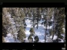
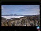
Thanks. I downloaded the flt log files and converted both (attached), using the phantomhelp.com tools I accessed from this site. As I compared them to the Flight Data Center stats on the DJI Fly app (in Profile), I realized there is a conflict in the order of what I saw and heard and what the Flight Data Center reported. It shows the long flight second and the short flight first. The log notes early on the drone was ascending to return home. It actually landed and then took off, as I mentioned in yesterday's post, but wasn't in the air long before it tried to land and crashed. At the time it was unresponsive to commands from the controller. It also indicates and altitude of over 900 feet. I set the maximum at 390, but I suppose this could be accurate in that it flew downslope for 2,368 feet (according to the Flight Data Center), or 1072.7 feet (according to the flight log). These altitude reports are common in the mountains. If you fly upslope on a mountain that is 1,000 feet above you, you will quick run into it if you set the altitude below 394 feet. And you will have the opposite problem when flying downslope. Another observation: I got a notice that the gimbal had issues rotating. I figured this might be because when the drone lost connectivity it eventually landed. The only places it could have landed other than my landing pad, were in the snow. I figured that was consistent with the gimbal having issues turning as the snow was deep. After the second takeoff, that message did not reoccur. Photos show the camera, at least, was not compromised. Several reports from data and observation don't jibe. Here is another variable: On Feb 4 I was on another mountain, also flying over deep snow. That flight had no difficulties, but when I returned from that hike, I noticed the drone was on and very hot to the touch. No question I turned it and the controller off before packing it up in the DJI case, as I use a checklist and have followed it since the beginning flights with this drone. But it had the wetsuit on with the power button insert. I have inadvertently turned the drone on in the past with this insert while putting the wetsuit on. The insert fits tightly into the hole above the power button, and must be pushed down to seat. If you push it down in increments, you are apt to turn the drone on, which I learned early on with this wetsuit. Since then I've been careful not to push it down too far, even at the risk of losing it on a flight, or elsewhere, but it stays put very well. Lesson learned: If you are hiking in rough terrain and carrying the DJI drone bag on your back (I had it in a backpack), you may well jostled it around to the point that it turns the drone on. So, remove the wetsuit's power button insert and put it elsewhere. In this case, after this incident, I thought the system was OK. The battery charged up as usual and the drone responded to commands normally on the ground. Note: In addition to the data files which I uploaded above, are one of the photos preserved in the Flight Data Center, as well as the Flight Data Center flight descriptions. One of the photos is below. Thanks for any insight you have. The URLs for the converted data files, if this saves you time, are
Attachments


Other than trees being very good at isolating radio signals. If the drone was line of sight when it disconnected that first time - at 109' out from where you launched - seems there was a fault in the controller or drone. Especially since there was no warnings in the log for weak signals. Cold might be the issue, the MA2 is rated to -10c, or 14f. Somewhere read it was 10f up there?
The second leg, it appears the drone flew normally - as if it launched from where it had disconnected in the first flight - flew out a thousand feet and returned. Then it landed at the takeoff point, but probably found a bush or tree and got hung up. Hence all the motor errors and weird 50mph wind speeds reported.
Did you locate the drone? It should be about 300 feet up from where you were standing. Maybe in a tree.
Last edited:
Other than trees being very good at isolating radio signals. If the drone was line of sight when it disconnected that first time - at 109' out from where you launched - seems there was a fault in the controller or drone. Especially since there was no warnings in the log for weak signals. Cold might be the issue, the MA2 is rated to -10c, or 14f. Somewhere read it was 10f up there?
The second leg, it appears the drone flew normally - as if it launched from where it had disconnected in the first flight - flew out a thousand feet and returned. Then it landed at the takeoff point, but probably found a bush or tree and got hung up. Hence all the motor errors and weird 50mph wind speeds reported.
Did you locate the drone? It should be about 300 feet up from where you were standing. Maybe in a tree.
View attachment 144774
Thanks. It's a bit confusing at this point. We searched for several days based on the location shown -- on the ground (in the snow) and in the trees. We couldn't find it. An earlier post by zeusfl indicated the wind was 50 mph+ for almost five minutes of flight at altitude, which would have been too much for the drone. Except if I reading the table he sent correctly, the wind was blowing from the SE. That would have blown the drone back to the landing spot. Surface winds were blowing from the WSW that day, 15 mph, but as a storm system had blown through the day before, I couldn't say which direction the winds were blowing at 300 feet. FYI, the takeoff location was in the open area on the map under the printed name of the location, Palo Flechado. In the trees is where is supposedly landed the first time and crashed the second time. I wish I could be sure the controller is sound, as a replacement drone is on the way. Any ideas on how to verify this?
T
Thanks for posting the wind speeds. Yes, 50 mph would have been too much. Am I right in reading the wind direction on this chart at SE? If so, that would have been blowing the drone back toward the original takeoff spot, which was in the open area on the map a bit under the name Palo Flechado. Not in the trees. The drone's compass was calibrated and Home set at the original takeoff site. I got no message that the home location was re-set. I've got a replacement drone coming under the FlyAway provision of Refresh-Plus, so at this point I'm hoping the controller is OK. Not sure how to verify that.
Those wind speeds are not real. They are an artifact of the drone thinking it was flying, but not. It was on the ground, and stuck. The drone did a full RTH and Autoland. But never made it to the ground enough to turn off the motors. Somewhere in the landing it encountered an obstacle, and a motor stopped turning (branch the most likely reason, deep snow the next most likely). But the other motors were free to spin and my guess the drone thought it was still airborne and trying to stabilize. I haven't done a deep dive into the log, but the general altitudes, location data and messages are pretty clear what happened. The "interpretation" is about what happened during landing.Thanks for posting the wind speeds. Yes, 50 mph would have been too much. Am I right in reading the wind direction on this chart at SE? If so, that would have been blowing the drone back toward the original takeoff spot, which was in the open area on the map a bit under the name Palo Flechado. Not in the trees. The drone's compass was calibrated and Home set at the original takeoff site. I got no message that the home location was re-set. I've got a replacement drone coming under the FlyAway provision of Refresh-Plus, so at this point I'm hoping the controller is OK. Not sure how to verify that.
Look at the point 5m 32.4s in the Log Viewer, that was where the drone touched something at 3.3 feet and the motor became stuck, then it fell, landing at about -8 feet. Negative numbers are relative - the important part is the difference between 3.3 and -7.9, or about an 11 foot fall.
| 5m 32.4s | P-GPS | 12satellites | 3.3ft | N/A | 8.7mph | 13.4ft | 73% | 11.436V | 3.80V | 3.82V | 3.82V | 0.022V | Motor unable to rotate. Check for objects blocking motor |
Then, a few seconds later the camera becomes obscured and the drone stops moving...
| 5m 35s | P-GPS | 12satellites | 0.3ft | N/A | 1.3mph | 12.5ft | 73% | 11.598V | 3.88V | 3.87V | 3.85V | 0.038V | Vision sensor(s) blocked. Fly with caution. |
| 5m 36.7s | P-GPS | 13satellites | 0.7ft | N/A | 0mph | 13.7ft | 73% | 11.609V | 3.89V | 3.87V | 3.85V | 0.039V |
A bit more from the log: at 2m 58s the drone entered RTH when it was 1048 feet away. Probably from your controller command.
| 2m 58s | Gentle GPS | 16satellites | 119.8ft | N/A | 12.7mph | 1,048.4ft | 84% | 11.636V | 3.92V | 3.88V | 3.84V | 0.085V | |
| 3m 0s | Gentle GPS | 16satellites | 120.1ft | N/A | 1.1mph | 1,063.7ft | 84% | 11.636V | 3.92V | 3.87V | 3.84V | 0.082V | |
| 3m 1s | Go Home | 16satellites | 119.8ft | N/A | 0.7mph | 1,064.8ft | 84% | 11.745V | 3.96V | 3.91V | 3.88V | 0.078V | |
| 3m 5s | Go Home | 16satellites | 119.4ft | N/A | 0.7mph | 1,071.5ft | 84% | 11.689V | 3.94V | 3.89V | 3.86V | 0.083V | Auto returning to home. |
Then at 4m 8s it transitioned to auto-land at the Home point, ~1.5ft, part of the RTH protocol.
| 4m 7.7s | Go Home | 17satellites | 280.5ft | N/A | 0.7mph | 1.5ft | 79% | 11.716V | 3.93V | 3.91V | 3.88V | 0.051V | |
| 4m 8.1s | Go Home | 16satellites | 280.5ft | N/A | 0.7mph | 1.0ft | 78% | 11.749V | 3.94V | 3.92V | 3.89V | 0.048V | |
| 4m 8.9s | Auto Landing | 16satellites | 280.5ft | N/A | 0.7mph | 0.3ft | 78% | 11.722V | 3.94V | 3.91V | 3.88V | 0.055V | |
| 4m 9.3s | Auto Landing | 16satellites | 280.5ft | N/A | 0.2mph | 0.4ft | 78% | 11.722V | 3.94V | 3.91V | 3.88V | 0.055V |
Last edited:
Similar threads
- Replies
- 9
- Views
- 604
- Replies
- 5
- Views
- 779
- Replies
- 28
- Views
- 4K
- Replies
- 3
- Views
- 566


DJI Drone Deals
New Threads
-

-
DJI Mini 5 Pro: Which Color Profile Should You Actually Use?
- Started by trisen1981
- Replies: 0
-

-

-

Forum statistics
