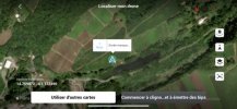
The TXT log is corrupt or this flight was made with the latest version of the DJI FLY app & the encryption have been changed again ... & not even Airdata.com can decrypt it now ...
The DAT log don't give enough to predict anything beside giving a couple speculative alternatives for the cause.
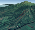
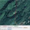
The flight was made here within the red square ... it was performed mostly downhill, that's why the negative height figures.
The indicated wind speeds during the flight from the DAT gives this according to the green graph & the outgoing flight was down wind. No info about the RTH height ... but as the HP was uphill a failsafe RTH would likely have sent up the AC very high above ground beneath.
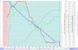
In the end of the flight it seems that the connection is lost as nothing is recorded ... all data flatlines between 677sec as shown below...

And here the chart from the above point ... every data point flatlines.
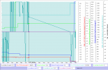
The log recording resumes then again at 742sec & the AC have moved a considerable distance.
And the chart values from that point ...
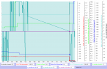
So nothing is recorded during 65sec ... enough for triggering a failsafe action but nothing is shown in the log, instead the AC is only further away, approx 20m lower & is maneuvered as nothing have happened during the recording pause.
Either this only was a disconnect to the mobile device, & the RC kept working (but strange to continue to fly in that distance without a working live stream?) or the failsafe was set to hover & the AC was blown further down wind ... or the HP was wrongly recorded for some reason?
But anyhow ... when the recording is resumed the AC is steered further away by means of a positive aileron input (right stick to the right) as nothing strange is going on ... then the log ends with the AC midair.
So this possibly could have been a blow away down wind when the RC lost connection, a AC malfunction ... or something entirely different ... unfortunately to little data to look at.
The last coordinates recorded was:
Lat: 14.76
Lon: -61.1774


