DJI Mavic, Air and Mini Drones
Friendly, Helpful & Knowledgeable Community
Join Us Now

lost in carolina

no not me not from jersey these are down south robeson county nc poke all the fun you want can take you or any body wants to see or disprove to launch sight were you will see for self the numbers my question is why here ? the numbers we are seeing nightly its crazy and im sure its being squashed or you would have long ago heard about it im just trying to share what i see keep an open mind look at what im posting im a simple man with a cheap cellphone trying to understand whats happening here will try to
To view this content we will need your consent to set third party cookies.
For more detailed information, see our cookies page.
post a link to a vid made last night stars dont travel under the clouds go look for self
That's a very nice time lapse video.

Those white pinpoints look like stars, moving east to west in the sky as the Earth rotates, with clouds obscuring them at times. An app like Sky Map will create a real time star chart you can compare them to.

 
That's a very nice time lapse video.

Those white pinpoints look like stars, moving east to west in the sky as the Earth rotates, with clouds obscuring them at times. An app like Sky Map will create a real time star chart you can compare them to.

i agree but the ones clearly flying under cloud cover then illuminated by early sunlight theres no question i see passenger airline traffic all the time im surronded by airports what im seeing flys under them i dnt even see the c 130 cargo or fighter jet traffic none since these things showed someone knows you cant have pilots out putting around without being informed to keep eye out or avoid certain areas im sure
 
i agree but the ones clearly flying under cloud cover then illuminated by early sunlight theres no question
Where in the video? At around 0:45 as the sky begins to get lighter, I see stars following the same path and speed as the others earlier in the night.
i see passenger airline traffic all the time im surronded by airports what im seeing flys under them i dnt even see the c 130 cargo or fighter jet traffic none since these things showed someone knows you cant have pilots out putting around without being informed to keep eye out or avoid certain areas im sure
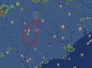
Have you used something like FlightAware on the web to look at air traffic? Here's what's showing as of about 1915 this evening in southeastern North Carolina. The red is a very roughly the Robeson County area.

Screenshot 2025-07-21 181441.jpg
 

DJI Drone Deals

New Threads

Forum statistics

Threads
137,808
Messages
1,631,075
Members
166,322
Latest member
Trini
Want to Remove this Ad? Simply login or create a free account