DJI Mavic, Air and Mini Drones
Friendly, Helpful & Knowledgeable Community
Join Us Now

Lost the drone again. Find 23 and win $20

scott492010

Well-Known Member
Joined
Oct 11, 2022
Messages
169
Reactions
263
Age
48
Location
Ohio, USA
Site
www.youtube.com
I was flying my drone at a altitude of approx. 200ft half way between the front porch and the road. It was a test flight. I do not remember which direction but i began to move forward and instantly lost connection between the drone and the controller. I looked up and there was nothing above. I found the battery of the drone on the yellow line in the road perfectly in front of the porch. My theory is that upon which time i began to move forward somehow the battery was ejected. This leads me to believe that i was moving towards the bean field on the other side of the road. This is 20 minutes of my three hour search of which i found nothing.

This was the first flight since the last crash which was almost identical in circumstance. The drone was hovering facing the west at approx. 250ft. The drone was found approx. 25 feet to the south and the battery was found approx. 25 feet to the north.

For an idea of what the drone looks like check out this video:
To view this content we will need your consent to set third party cookies.
For more detailed information, see our cookies page.


To view this content we will need your consent to set third party cookies.
For more detailed information, see our cookies page.

in short.... i have a ejector :)
 
  • Like
Reactions: rjwmorrell
That sucks. Sorry man, but there has to be some kind of moral of the story about rejecting that which helps us to soar....

Good luck! I bet with a log file there are people here that can narrow down the location and whether it landed on it's front or back. : )
 
Post the flight logs ?
the question here then is....how did the battery end up in the middle of the road directly in front of the house? I am guessing it was the slight breeze ..... if that is the case the drone must be around that telephone pole.... what i find interesting is the home point should of been either inside the front door or on the porch. at no point did i physically have the drone near where it says the home point was/is.


Here is the sharing link:


Last edited:
I would look north and east of where you found the battery.
Assuming it was a battery loss it would take around 4 seconds to fall from 207ft. Airdata thinks the wind was approximately 13ft/s blowing to the NNE.
Why isn't the road covered by google street view ?
How long after the crash did you find the battery ?
Was it swollen ?
Did any vehicles pass between the time of the crash and finding the battery?
This was not the renewed battery, correct ?
If so how old is this battery ?
north east of where i found the battery would be that telephone pole with the long uncut grass around it. also there is a junction box of some kind at the base of that telephone pole. I will check the area again during daylight.

I am not sure about google street view.

i found the battery within a minute of loss of connection between controller and air 2s.

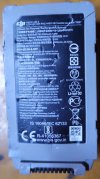
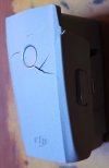
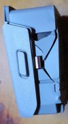
yes the battery is swollen. I could of swore this battery was NOT swollen when i put it in the drone. I remember specifically testing it by laying it on the counter and seeing if it wobbled.

No vehicles passed between the time of the crash and finding the battery.

It is not the renewed battery.

I had previously put stickers on my batteries which dated and or numbered them. This battery somehow does not have a sticker. I am unsure but i believe this battery to be one i bought last year brand new.

I cannot remember how to identify batteries or even how to tell how many times they have been charged.

20240624_051305.jpg

20240624_051315.jpg

20240624_051325.jpg
 
Airdata thinks the battery has been charged 20 time. Look at the above airdata, click on "power" then "battery info".

You should check that page via your own Airdata account, it might show you the battery's data of manufacture.

That page, in this thread, does NOT show me that information but when I upload the txt to my own Airdata account it shows me the date of manufacture to be 2021-01-31.
However the Phantomhelp CSV shows the charge count to be 62, column title = BATTERY.timesCharged, column DM. I am inclined to believe the PH CSV.

The renewed battery CSV does not show a charge count in the PH CSV, ditto the battery of your disconnection and crash flight. My Airdata account sees the date of manufacture for the renewed battery to be 2020-11-17. My Airdata account sees the date of manufacture for the discon & crash battery to be 2021-03-15.

I think Airdata derives the charge count from the number of times your Airdata account has seen a significant increase in charge level for a given battery in the uploaded flight using logs.
My Airdata account shows the charge count to be 1 for all your batteries.

I find that a bit pleasing, from my own logs for my drones I recollect that things like the 'charge count' remain stored even when logs are deleted, I was sort of concerned that I would see the charge counts that you might see but it looks as if the data is kept personalised. :)
 
Last edited:
what i find interesting is the home point should of been either inside the front door or on the porch. at no point did i physically have the drone near where it says the home point was/is.
Are you saying that the actual takeoff/home point was on the east side of the house, while the flight plot shows it on the south side?
 
Last edited:
  • Like
Reactions: Yorkshire_Pud
Are you saying that the actual takeoff/home point was on the other side of the house, the side with the gravel driveway?
oops missed that, the GPS was poor at the start of the flight but only for 1.3 seconds.
I reollect one of my logs gave a ridiculous start location with poor GPS and I don't mean (0,0).
It might be useful if Scott marked the launch point on a screen capture and added what he thinks was the flight track.
Something doesn't add up.

If the flight ended at the location shown on the track and the speed was less than 1 mph with light wind, it seems unlikely that the battery would have landed on the paved road.
 
  • Like
Reactions: scott492010
Are you saying that the actual takeoff/home point was on the east side of the house, while the flight plot shows it on the south side?
the actual take of point was the front porch. i took off from the porch with five satellites and no gps. hovered half way between road and porch until homepoint was made with 13 satellites. yet this is not what is represented by the logs.
 
the actual take of point was the front porch. i took off from the porch with five satellites and no gps. hovered half way between road and porch until homepoint was made with 13 satellites. yet this is not what is represented by the logs.
Your description and the logs differ on all those points. The log dates the flight as Jun 22nd, 2024 08:38PM. Does that agree with the flight you're describing?
 
I finally found my drone that ejected the battery and fell from approx. 200ft only to be lost for three days and surviving a rain storm the first night alone.

View PhantomHelp flight log:

View Airdata UAV flight log:


To view this content we will need your consent to set third party cookies.
For more detailed information, see our cookies page.
 
I am pleased you found the drone but I would suggest that you get a landing mat and stop landing the drone on the naked lawn. You have a PM.
 
I'm curious, how close was Yorkshire_Pud with his estimate at where to look?
Assuming the video and log are for the same flight the log shows a hover starting at 1044sec, 17:24, the coordinates at that hover were 40.6016376, -84.24526544.
The cordinates of the end point of the crash log are 40.60137704, -84.2454693.
If those are correct, the OP has, I think, yet to confirm this, the distance is around 113.5ft, 34.5m, which is slightly more than double the distance a 4 second fall in a 13ft/s wind would produce.
 
I'm curious, how close was Yorkshire_Pud with his estimate at where to look?
Personally i thought they were 100% accurate if you measure from where the battery was found. If you go by the coordinates you will get a headache and find yourself in the shower laying in the fetal with "the crying game" playing in the background....

To view this content we will need your consent to set third party cookies.
For more detailed information, see our cookies page.
 
Last edited:
Assuming the video and log are for the same flight the log shows a hover starting at 1044sec, 17:24, the coordinates at that hover were 40.6016376, -84.24526544.
The cordinates of the end point of the crash log are 40.60137704, -84.2454693.
If those are correct, the OP has, I think, yet to confirm this, the distance is around 113.5ft, 34.5m, which is slightly more than double the distance a 4 second fall in a 13ft/s wind would produce.
i do not believe these to be correct because i had attempted to move forward as the controller and drone disconnected.... i think it was moving forward which is why the battery was found in the middle of the road.
 
Lycus Tech Mavic Air 3 Case

DJI Drone Deals

New Threads

Forum statistics

Threads
133,798
Messages
1,587,612
Members
162,469
Latest member
BugHunter