@scott492010
in the video you seem to ask why I was asking you to supply what you think was the course flown by the drone ?
My answer,
from post #4
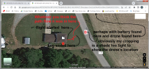
"what i find interesting is the home point should of been either inside the front door or on the porch. at no point did i physically have the drone near where it says the home point was/is."
in post #9 MS Coast asked you "
Are you saying that the actual takeoff/home point was on the east side of the house, while the flight plot shows it on the south side?"
You replied to MS Coast with "
the actual take of point was the front porch. i took off from the porch with five satellites and no gps. hovered half way between road and porch until homepoint was made with 13 satellites. yet this is not what is represented by the logs."
In post #20 you wrote "
i do not believe these to be correct because i had attempted to move forward as the controller and drone disconnected.... i think it was moving forward which is why the battery was found in the middle of the road".
I assume that the disbelief refers to the cordinates of the disconnection point and NOT the cordinates of point where the drone was found.
All of your responses, as quoted above, suggest to me that you do not think that the log portrays the course flown accurately.
To me it is therefore logical to ask you to draw what you think was the course that the drone flew.
Ignoring the start and finish point and thinking only about the path flown by the drone, i.e. the attached entitled "path flown".
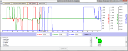
If you replay the phantomhelp replay at 1/4 speed and watch the path of the drone, the joystick position and the artificial horizon they correspond fairly well with one another until around 25 seconds.
Thereafter the horizontal movement has, I think, no corresponding elevator/aileron movement but this is mainly whilst you are commanding full climb.
I have sometimes noticed the same thing with a mini, i.e. in wind it can not hold position when it is being commanded to maximum climb rate and I therefore think that this forward movement was wind drift caused by the drone being unable to hoild position during the commanded climbs.
Therefore I think the flight path shown is reasonably accurate though it apparently has an offset.
As for what happened after the disconnection you are the only one who can say what stick commands were issued.
With regards to what I was asking for, rather than a near 11minute video the attachment "what I was hoping for" would have been more than adequate and probably have taken you far less time.