I shot a variety of country real-estate photos today and downloaded them all and am looking at the images in programs from Photoshop to Photo Mechanic. While I see a wealth of IPTC and raw data in the files, I don't see any way to determine what direction the Mavic was facing when the photo was taken. I could take notes on each image off the controller perhaps as I shot them but that is tedious. Surely there is a way to look at the file data, the same way you can see lat/long, GPS altitude, exposure, etc and see what magnetic heading the drone was pointing (not flying, but pointing) when the image was capture. Simply put, the orientation of the photo. Thanks for any help.
You are using an out of date browser. It may not display this or other websites correctly.
You should upgrade or use an alternative browser.
You should upgrade or use an alternative browser.
Magnetic direction of photos
- Thread starter zryall3
- Start date
That information (and lots more) is all in the metadata captured with each image.I shot a variety of country real-estate photos today and downloaded them all and am looking at the images in programs from Photoshop to Photo Mechanic. While I see a wealth of IPTC and raw data in the files, I don't see any way to determine what direction the Mavic was facing when the photo was taken. I could take notes on each image off the controller perhaps as I shot them but that is tedious. Surely there is a way to look at the file data, the same way you can see lat/long, GPS altitude, exposure, etc and see what magnetic heading the drone was pointing (not flying, but pointing) when the image was capture. Simply put, the orientation of the photo. Thanks for any help.
But basic metadata viewers like you've used only show part of the metadata.
Here's a small part of the XMP section of the metadata which gives the heading for the drone as well as where the gimbal was pointing. which will show lots more including this:

You need a viewer that will show the XMP section of the metadata.
Picture Information Extractor is a good free one.
LeeB
Well-Known Member
It appears the PIE is Windows only. Do you know of a good for Mac?That information (and lots more) is all in the metadata captured with each image.
But basic metadata viewers like you've used only show part of the metadata.
Here's a small part of the XMP section of the metadata which gives the heading for the drone as well as where the gimbal was pointing. which will show lots more including this:

You need a viewer that will show the XMP section of the metadata.
Picture Information Extractor is a good free one.
Sorry .. I'm not a Mac person.It appears the PIE is Windows only. Do you know of a good for Mac?
There must be some metadata viewers that display the XMP data.
Google might be a good place to start.
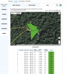
AirData shows the gimbal heading data but I can't say I would vouch for the accuracy of the data points. To see the info in Airdata go to My Logs and then click on the flight time/date. On the left of the map click on Media and then click on Map at the top of the map display. It will show the map with the drone position and a triangle depicting where the gimbal was pointed:

If you click on the green shaded Photo button you get the following:

All well and fine but in the case of this specific map I know exactly where I had the drone pointed and what I was shooting and 18º is flat out wrong since I was pointed at roughly 180º instead. Sadly all of the info on the images in Airdata is based on the flight time and not real world clock info so if you take a lot of images connecting a given log entry to an image you have downloaded is not a straightforward task. AirData does not show thumbnails for the entries shown in the table so you are left to make your own calculations as to when you started the flight (which it does show) and then what the actual time was to match up the timestamps in your images.
I thought I was getting useful data prior to this particular flight but once I lined up the images and actual maps I found that the gimbal heading data was pretty much worthless. I did use a text editor to confirm the XML data and AirData is correctly showing what was recorded by the drone. I have read similar discrepancies about the log data for GPS altitude info so this isn't a complete shocker.

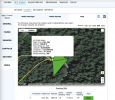
If you click on the green shaded Photo button you get the following:

All well and fine but in the case of this specific map I know exactly where I had the drone pointed and what I was shooting and 18º is flat out wrong since I was pointed at roughly 180º instead. Sadly all of the info on the images in Airdata is based on the flight time and not real world clock info so if you take a lot of images connecting a given log entry to an image you have downloaded is not a straightforward task. AirData does not show thumbnails for the entries shown in the table so you are left to make your own calculations as to when you started the flight (which it does show) and then what the actual time was to match up the timestamps in your images.
I thought I was getting useful data prior to this particular flight but once I lined up the images and actual maps I found that the gimbal heading data was pretty much worthless. I did use a text editor to confirm the XML data and AirData is correctly showing what was recorded by the drone. I have read similar discrepancies about the log data for GPS altitude info so this isn't a complete shocker.
I am always able to get metadata from Photoshop in combination with RAW (Bridge).That information (and lots more) is all in the metadata captured with each image.
But basic metadata viewers like you've used only show part of the metadata.
Here's a small part of the XMP section of the metadata which gives the heading for the drone as well as where the gimbal was pointing. which will show lots more including this:

You need a viewer that will show the XMP section of the metadata.
Picture Information Extractor is a good free one.
When I go to Flight Data Center in the Go Fly app under Profile, I can watch my flights on the map and the orientation on the drone. North is up on the maps. Would that info be good enough to orient your view in your photos? I guess having that heading in the metadata would be easier LOL.I shot a variety of country real-estate photos today and downloaded them all and am looking at the images in programs from Photoshop to Photo Mechanic. While I see a wealth of IPTC and raw data in the files, I don't see any way to determine what direction the Mavic was facing when the photo was taken. I could take notes on each image off the controller perhaps as I shot them but that is tedious. Surely there is a way to look at the file data, the same way you can see lat/long, GPS altitude, exposure, etc and see what magnetic heading the drone was pointing (not flying, but pointing) when the image was capture. Simply put, the orientation of the photo. Thanks for any help.
You can get metadata, but you only get to see a small part of the metadata.I am always able to get metadata from Photoshop in combination with RAW (Bridge).
You need a more comprehensive metadata viewer to see the XMP data, which is what the OP was asking about.
This is all the metadata that Photoshop gives for one of my drone images:

But this is what PIE shows for the same image:

Wow! That is amazing! But actually I usually only need what Photoshop offers such as date, time, exposure settingsYou can get metadata, but you only get to see a small part of the metadata.
You need a more comprehensive metadata viewer to see the XMP data, which is what the OP was asking about.
This is all the metadata that Photoshop gives for one of my drone images:

But this is what PIE shows for the same image:

Dale
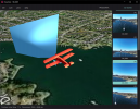
Your assumption is that the metadata is correct to begin with. In the case I cited above the metadata was simply wrong to begin with. That was a big disappointment for me.we show where the drone and gimbal was pointing to. Even though PanoVolo is primarily a panorama stitcher, it will show metadata for any drone photo
Hi Alan, the gimbal orientation is wrong in your case. I have seen it too. Drone reports gimbal yaw that is simply physically impossible (the gimbal cannot yaw that match). We use drone yaw (ignoring gimbal yaw angle) and tested on many images and it appears to be correct (it accurately matches the scene within the frame). Hope this helps. No idea why DJI writes these spurious gimbal yaw angles into metadata.
DJI calls it GPS altitude, but it doesn't come from GPS at all.I have read similar discrepancies about the log data for GPS altitude info so this isn't a complete shocker.
It comes from a faulty algorithm applied to barometric data, but not allowing for normal variation of air pressure.
This can give some obviously wrong information like this:

But it's not a case of the drone wrongly recording, it's the formula used for the calculation being wrong.
BOREAS
Member
I use Exif Tool Reader, free on the App Store. The magnetic heading the camera in deg is towards the end of the long list of data providedIt appears the PIE is Windows only. Do you know of a good for Mac?
Similar threads
- Replies
- 4
- Views
- 742
- Replies
- 3
- Views
- 783
- Replies
- 36
- Views
- 5K
DJI Drone Deals
New Threads
-
-
-
-
Mini 3 Late Autumn over Ontario Woodland
- Started by Robert Prior
- Replies: 1
-


