DJI Mavic, Air and Mini Drones
Friendly, Helpful & Knowledgeable Community
Join Us Now

Maps not showing properly!

Rogerc

Well-Known Member
Joined
Jun 24, 2019
Messages
81
Reactions
57
Location
Gilroy, California
I am coming from a Mavic 2 Pro to a Mavic 3 Classic and very confused by the maps I am seeing on my DJI RC controller.

I am not seeing the maps clearly until I put my finger on the screen and them the maps displays in full color and display like they do on my M2P. The maps on my M3C are just not showing properly.

What am I doing wrong?

Do I have to download maps and how do I do this?
Not sure what exactly you mean by not showing properly but on my RC Pro the satelite maps are blurry and pretty much unusable. Very low resolution is perhaps the word to describe how they look. Even on the standard view maps I can not zoom in to see a small area where I want to fly and create waypoint mission. It is shame that the maps are so bad because the new waypoints feature is amazing.
 
  • Like
Reactions: LoudThunder
I am coming from a Mavic 2 Pro to a Mavic 3 Classic and very confused by the maps I am seeing on my DJI RC controller.

I am not seeing the maps clearly until I put my finger on the screen and them the maps displays in full color and display like they do on my M2P. The maps on my M3C are just not showing properly.

What am I doing wrong?

Do I have to download maps and how do I do this?
Your maps are displaying "as designed" by DJI's stupid implementation of their new 1000m altitude limit. They have added a new obstructing gray altitude layer of 500m in a radius of 50km around every airport in the U.S.! The only way to see "through" it is to continuously touch the screen, or turn off all Altitude Layers on the map!

So, turn off the Altitude Layer, which will also hide all the real altitude restrictions along the flight line extensions of all nearby airports! Dumb!

The only place on the map you won't see the obstructing gray 500m layer is where you can fly to 1000m, which is only way out in the boonies, away from all civilization, but you still are not legally allowed to fly higher than 400' AGL! So, it is only useful for mountain climbing, at least 50km away from the nearest airport! So, for this rarely needed capability, we now can't see our maps anywhere else, unless we turn off the Altitude Layer!

Really dumb, DJI!
 
I am coming from a Mavic 2 Pro to a Mavic 3 Classic and very confused by the maps I am seeing on my DJI RC controller.

I am not seeing the maps clearly until I put my finger on the screen and them the maps displays in full color and display like they do on my M2P. The maps on my M3C are just not showing properly.

What am I doing wrong?

Do I have to download maps and how do I do this?
To turn off the altitude zone click on the maps and 6 boxes will appear click on the first one and then select altitude zone and your problem will be resolved.
 
  • Like
Reactions: LoudThunder
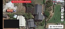
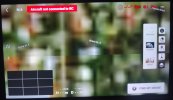
The issue is with the map provider that DJI is using on the RC.
Mine is fine when I use my N1 remote with my Android phone but unusable when I use the RC.
Fix it DJI...
Fly on Android phone.jpg
Fly on DJI RC.jpg
 
Last edited:
  • Wow
Reactions: LoudThunder
Take your point, yes it is the satellite view, but the real issue is the difference the clarity, after all in my case they are both Android operating systems...
 
  • Like
Reactions: LoudThunder
Lycus Tech Mavic Air 3 Case

DJI Drone Deals

New Threads

Forum statistics

Threads
130,995
Messages
1,558,715
Members
159,983
Latest member
Glenn-S