DJI Mavic, Air and Mini Drones
Friendly, Helpful & Knowledgeable Community
Join Us Now

Mavic 3 Gone Mad!

silent_hawk

New Member
Joined
Dec 22, 2023
Messages
3
Reactions
0
Age
34
Location
East Coast
1 min into my first flight, my Mavic 3 started doing it's own thing. Made a beeline towards a building then changed directions and crashed into the ground at high speed. I wasn't touching any of the sticks/controls - was just holding the RC.

I've attached a CSV here. This is my first drone and first flight. Would appreciate help interpreting what happened so that it doesn't happen again. Thank you.
 

Attachments

before taking off give your drone enough time to set its home position. Look at the number of satellites on your controller screen. It should be at least 10.
And always wait for the message "home point updated".
 
before taking off give your drone enough time to set its home position. Look at the number of satellites on your controller screen. It should be at least 10.
And always wait for the message "home point updated".
It's not the number of satellites that's significant. It's the color of the satellite icon. If the icon is not white, the position hasn't been adequately established. I've seen the satellite count as high as 20 with the icon still yellow/orange.
 
  • Like
Reactions: mobilehomer
1 min into my first flight, my Mavic 3 started doing it's own thing. Made a beeline towards a building then changed directions and crashed into the ground at high speed. I wasn't touching any of the sticks/controls - was just holding the RC.

I've attached a CSV here. This is my first drone and first flight. Would appreciate help interpreting what happened so that it doesn't happen again. Thank you.
You were flying in Class B airspace. It's not related to your crash, but LAANC approval was required.

One of the forum members who are well versed in understanding flight logs will probably speak up, but I suspect that your drone's compass was biased by ferrous metal or a magnetic field. Did you verify that the compass direction shown on the screen was accurate before takeoff?

Screenshot 2023-12-22 113845.jpg
 
  • Like
Reactions: redserv
At first look, Not sufficient satellites + looks like was a dark environment so the vision sensors will not work on those conditions. Not having sufficient satellites, the drone will be flying in ATTI mode.
 
...Would appreciate help interpreting what happened so that it doesn't happen again. Thank you.
I'm not sure I saw that. But it's possible that I missed it. You think it was headed "home"? In future, I should set the home point at the start of every flight?
Sorry for your loss, but I'm afraid that you should have had some kind of incident sooner or later anyway, your comments really indicate that you don't know the very basics around drone flying & you unfortunately started to seek info first after a incident.

This time it wasn't a classic newbie error though, you barely missed out on those about recorded HP & enough locked satellites... instead it was another famous pilot error that actually happens even more experienced flyers that haven't bother with "How can DJI drones fly so stabile & hold position even though the drone is affected by heavy winds".

If we start from the beginning of the flight...

It's apparent that you didn't knew the importance of a HP & a proper sat.lock... you took off without any of them. What saved you from consequences from that was that you stayed just about 10ft above the launch spot & didn't fly out until about 92-95sec into the flight, this was where the GPS quality was good enough to have a HP recorded... so a lack of GPS support, HP or VPS sensors not functioning hadn't anything to do with your incident.

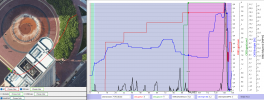
In below chart with the synced 2D sat pic. with the flight path & drone icon with indicated yaw direction... I've placed the chart marker at 94,8sec, it's then the HP is recorded, & the drone icon show that it's still above the launch spot (And even though it looks like the flight was above the high building, it was conducted behind it much lower...)

All goes then without drama... until 123sec. There you have ascended up to 19ft & the drone started to be affected by winds & needed to counteract in order to hold position. It's here the drone quickly gain speed & starts to fly away uncontrollably... reaching a heading speed of 34,3mph.

(Click on the chart to make it larger, the legend under the chart explain the graphs & shows values from where the chart marker is placed)
1703271457617.png

All that happens from 123sec into the flight indicate that your drone had a "Yaw error"... simply said, your drone didn't know in which direction it was pointing, this caused the flight controller to counter the affecting wind with the wrong motors. The cause to this error was that you powered the drone on in magnetic interference.

Investigating the velocity deviation between the GPS & the IMU should normally show values very near to 0mph... If there is deviations it indicates usually either a IMU failure or a yaw error...

This is how it looks when the incident starts...

The Green graph shows that the deviation in an easterly direction reaching as much as 13,4mph
The red graph shows that the deviation in an northerly direction reaching as much as 11mph

So this was very likely a plain yaw error incident... which is totally pilot related not knowing how to make sure all is good before take off.

If you want to learn how to avoid this & learn why this error happens, read this post -->My bad or not ?

1703272782384.png
 
Last edited:
@silent_hawk Is the map plot 'up the left' ?
I ask because the map shows the drone flying over a 25 storey building yet the miximum height is 22.3ft.
If the map IS up the left where were you flying?
 
@silent_hawk Is the map plot 'up the left' ?
I ask because the map shows the drone flying over a 25 storey building yet the miximum height is 22.3ft.
If the map IS up the left where were you flying?
"Up the left" must be one of those expressions from the east side of the pond. A cross-Atlantic equivalent to "gone south?"

It could be that the flight originated on the roof of that building. The altitude and flight path would make sense. [EDIT: Not so. See post #13.]
 
Last edited:
  • Like
Reactions: Yorkshire_Pud
@silent_hawk Is the map plot 'up the left' ?
I ask because the map shows the drone flying over a 25 storey building yet the miximum height is 22.3ft.
If the map IS up the left where were you flying?
...It could be that the flight originated on the roof of that building. The altitude and flight path would make sense.
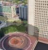
No... the 2D sat pic from CsvView give the wrong impression, the flight path is there allowed to be visible through the building, it looks like this in the 3D version in GE (made a small comment about this in post #10).

1703281443936.png
 
  • Like
Reactions: Yorkshire_Pud
No... the 2D sat pic from CsvView give the wrong impression, the flight path is there allowed to be visible through the building, it looks like this in the 3D version in GE (made a small comment about this in post #10).
Yes, of course. I made the silly mistake of looking at the flight path and rooftop as if the view angle was 90 degrees to the surface. Thank you.
 
No... the 2D sat pic from CsvView give the wrong impression, the flight path is there allowed to be visible through the building, it looks like this in the 3D version in GE (made a small comment about this in post #10).

View attachment 171265
looks like a very close call with the water though the drone may be dead anyway.
 
Can't imagine you're allowed to fly recreationally between high-rise buildings in what appears like an urban center like that.
 
  • Sad
Reactions: TonyPHX
ATTI mode mentioned earlier, if you're not sure what that is or haven't flown in Atti mode I would MOST certainly research it. It's basically flying the drone without it breaking, meaning if you send it one direction the only way to counter that direction is to move the stick in the opposite direction. No breaking when you release the sticks. Super easy to lose control and have no idea why you've lost control.

The first time I went up without satellites and my M3 went to Atti mode I literally had no idea what the hell was going on. Luckily I was way out in the desert and no structures around. After about 90 seconds, I was able to determine what the heck was happening and able to counter its movements and finally land. In an urban environment I would have crashed it into something...no doubt.
 

DJI Drone Deals

New Threads

Members online

Forum statistics

Threads
134,577
Messages
1,596,445
Members
163,078
Latest member
dewitt00
Want to Remove this Ad? Simply login or create a free account