DJI Mavic, Air and Mini Drones
Friendly, Helpful & Knowledgeable Community
Join Us Now

Mavic 3 signal loss

pat6

Member
Joined
Aug 9, 2024
Messages
12
Reactions
10
Age
29
Location
slovakia
Hello, I recently bought an M3 drone and managed to lose it... I made several mistakes, but now it doesn't matter. According to the flight log, the drone is located in a wooded area that is difficult to access. According to you, it will be where he had an "automatic landing" or continued somewhere else. The landing site is quite steep, didn't the drone move to a lower place? Apparently I should be looking for it in the treetops.

flight log

Please be patient, I'm using a translator.
I will be grateful for answers.
 
Last edited:
  • Like
Reactions: RodPad
Hello, I recently bought an M3 drone and managed to lose it... I made several mistakes, but now it doesn't matter. According to the flight log, the drone is located in a wooded area that is difficult to access. According to you, it will be where he had an "automatic landing" or continued somewhere else. The landing site is quite steep, didn't the drone move to a lower place? Apparently I should look for it in the treetops.

Greetings from Birmingham Alabama USA, welcome to the forum! We look forward to hearing from you!

Sorry for your loss, but I'm sure there are members that can help you.
 
If my information is correct the drone lost signal for the last time at approximately 981ft AGL, 2,360ft above take off.
It would have taken some time to descend from that height and the battery charge level was ticking down at roughly 18 seconds per percent.
I do not know the automated descent rate for the Mavic 3 but I suspect that there is a reasonable chance that the drone will have entered low battery RTH before it reached tree top level, that is if low battery RTH was not disabled by what ever you did to allow the drone to reach the heights it did.
Since the drone was well above the recorded RTH height, 377ft, the drone, if it did indeed RTH, would have RTHed at whatever height it was at when the RTH kicked in.
The ridge between the drone and home is approximately 1480ft above the take off point leaving approx 878ft of descent before the ridge became a problem for any RTH.

Do you have a log where the drone did an automated descent from a reasonable height so that we can work out the descent rate?
 
  • Like
Reactions: RodPad
The speed of descent during landing was 5.9 m/s. That's what dji rc shows.

And I don't have that record, I probably never used automatic descent or RTH.

I think he got over the trees within a minute, he was about 300m above them. So if he descended 5.9 m/s. The question is what did he do next? The battery still has more than 30% left. If I'm counting correctly... Do you think he just landed on the trees? where does the last record show? Or he was descending in the opposite direction above the trees, since the ridge was obstructing him in the right direction.

probably my "Reflections" will be mistranslated... :D
IMG_3099.jpg
 
  • Like
Reactions: RodPad
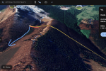
Which of these options do you think is the most likely?

Yellow is a straight line to HP.
Or he got stuck at the end of the red.
Or he tried to get off at RTH after the yellow light.
Or he just landed.
Screenshot 2024-08-09 at 17.03.18.png
If anyone has a similar experience, let me know... I must have lost it, but hope...
 
  • Like
Reactions: RodPad
So there was probably 47 - 48 seconds to tree top level. At disconnection the battery was 3 seconds into 39% so at a guess around 36% if it had descended into the trees.

I think everything will come down to whether or not it started a low battery RTH before it reached tree top level and I don't know enough to say if that happened.
At 4720ft from home I think it might, you used 32% of the battery to get out there but that was quite slow, about half RTH speed, so it would have been close to a Low battery RTH whatever happened.
LB RTH will be trying to get the drone home with more than 10% of the battery left.
But I could well be wrong about the RTH starting before tree top level.

You need @slup @BudWalker @msinger @sar104 @Meta4 for the likes of that.

Whatever happened I would start a search at the disconnection point and work your way towards the homepoint from there and check the trees as well as the ground.
 
  • Like
Reactions: RodPad
I should also say that, it is possible that the drone would have stopped its descent if/when it got down to near tree top level, because it considered the landing site unsuitable.
If it got that low and rejected the landing site it would have hovered until the LB RTH kicked in.

I am puzzled.
Why did you have the falisafe action set to "Land" for this flight ?
Why didn't you make the drone climb after the first signal warning and disconnectiion ?
 
  • Like
Reactions: RodPad
If he waited above the trees and then went LB RTH, which direction would he take when the ridge gets in his way?

I set the failsave incorrectly... and I didn't go up because I thought it would automatically return after losing the signal... just mistakes. (expensive mistakes)
 
Last edited:
  • Like
Reactions: RodPad
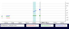
Looks to me like the M3 had started to land at the very end of the recorded log file. The flightAction had changed to Landing (RC Auto), vertical descent rate = 5.9 m/sec and horizontal speed was 0.0 m/sec.
1723223229616.png
The coordinates at the very end were latitude = 49.2239369828717 , longitude =19.1273314699906
 
  • Like
Reactions: RodPad
If he waited above the trees and then went LB RTH, which direction would he take when the ridge gets in his way?
I think there are two options, brake or bypass, I don't know where to look in the log for that setting even if it is recorded.
However I do see that some of the flight was flown in "P-GPS (Brake)" mode, see the column "OSD.flycState", but I do not know if that actually indicates that the OA option is set to brake.
I do not have a relevant drone with which to experiment.

Ahhh looking through the mavic 3 logs that I have saved, I have found some with the flight mode "P-GPS (Bypass)" and others with the flight mode P-GPS (Bypass). So it may be that your drone was set to brake, which would suggest that would stop and hover until critical battery forced it down in a controlled descent
I set the failsave incorrectly... and I didn't go down because I thought it would automatically return after losing the signal... just mistakes. (expensive mistakes)
Ah, mistakes happen :-(.
 
  • Love
Reactions: RodPad
Looks to me like the M3 had started to land at the very end of the recorded log file. The flightAction had changed to Landing (RC Auto), vertical descent rate = 5.9 m/sec and horizontal speed was 0.0 m/sec.

The coordinates at the very end were latitude = 49.2239369828717 , longitude =19.1273314699906
BudWalker, can you work out whether or not it would have started a Low Battery RTH before it descended to tree level ?
 
  • Like
Reactions: RodPad
BudWalker, can you work out whether or not it would have started a Low Battery RTH before it descended to tree level ?
Can't add much beyond what you guys have already observed.
 
  • Like
Reactions: RodPad and pat6
So I went there to look and I didn't see the drone. So I can say with certainty that it is not at the location of the last coordinates, neither on the ground nor in the trees.


Thank you all for trying to help and address this issue. If anyone thinks of anything else, feel free to write, I also quite enjoy the issue, flight records, etc...
 
Last edited:
  • Like
Reactions: RodPad
I went there to look and I didn't see the drone. So I can say with certainty that it is not at the location of the last coordinates, neither on the ground nor in the trees.

The elevation between the takeoff point and last recorded location are quite different:

1723301278569.png


Your flight log shows the drone was at an altitude of 1,363 feet at the last recorded location. Taking that elevation difference into consideration, it was probably only about 996 feet above the ground. And it might have been even closer to the landing location depending on how tall the trees were in that area.

Your flight log also shows the wind was pretty calm (5-8 MPH). So, the drone shouldn't have had any trouble staying close to that last recorded location as it was descending toward the ground.

GPS coordinates are not 100% accurate. I'd recommend you go to that last recorded point and look outward in about a 20 foot circle around that point. It's probably there somewhere -- maybe tough to see if it's stuck high up in a tree.

Did you happen to take a photo of that location? Just curious to see what it might have looked like since there are no images of that area available in Google maps, etc.
 
  • Like
Reactions: RodPad
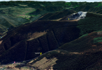
Well, when I was there, I climbed the tree about 4m from the coordinates. And I didn't even see him on the nearest trees. The trees are 20-30m high there.

The red dot is the GPS location and I climbed the tree marked with the blue arrow. Pretty scary...

IMG_3105.jpg
 
Last edited:
Lycus Tech Mavic Air 3 Case

DJI Drone Deals

New Threads

Members online

Forum statistics

Threads
133,130
Messages
1,580,407
Members
161,780
Latest member
GeoffreyBH