


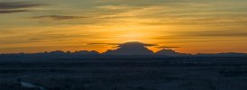
I went out for a day of shooting, leaving my home in North Pole Alaska to head south. I left around 8 am in pitch black and the first sunrise shots began an hour later around 9AM. The sun came up somewhere in "the flats" around 10:30 AM but in the mountains the sunrise depends on what's between you and the sun. I traveled for 200mi south past Nenana Alaska and Denali Nat'l Park taking pictures and video with my Mavic 3. I brought my Mini 3 Pro and Avata but never used them. I was travelling down the Parks hwy. I forget what number that Hwy is. We have, I think, 5 highways and sometimes you'll see comments about Hwy 1 or 3 and then you know it's somebody from Outside because most Alaskans I know have NO idea what the number is for the hwy they are on. But I digress. I headed south and got some shots of a beautiful sunrise (to be posted soon but there are several of them to work up) and video shorts of the steaming Nenana River. I shoot 5 shots AEB as a matter of course. I wonder what % of folks do that. Pretty high I'd guess. I forgot to mention. It was -32F or something close - at least at one point. I think it was more like -20 to 25 most of the day. I grabbed a shot of the temp shown in my car mirror. That will tell the truth. I had a fun day of shooting. Driving south past Denali Nat'l Park I took video and stills of interesting images (some to be posted soon) but was really struck by this panorama. It is comprised of 40 images, 8 AEB shots of 5 varying exposures (wish I could control the exp...) with the tele lens on my Mavic 3. I finished the day and turned around 20min or so into Broad Pass south of Cantwell. Upon the return, about 5miles south of Nenana (where the hills begin and cell phone service is lost) I glimpsed in my mirror a great sunset and pulled over immediately. There was just enough shoulder for my car but not much more than just enough, but traffic was very light. I'd guess that in the 200mi trip south I encountered 20 cars? Maybe not quite that many. Hardly anyone out. Not even too many truckers. So I see a great sunset in my rear view mirror and stop and throw up the drone. I had been using my 12.9" iPad but sunsets travel fast so I connected my iPhone to my controller (faster than the iPad setup I use) and tossed the Mavic 3 up. DJI has no auto panorama function when using the tele lens so I shot 5 images moving my camera view from right to left, then pointed it down and shot from left to right. I use the DJI tic tac toe overlay to overlap a 1/3 of the image for each subsequent shot and it's easy to be quite accurate using that overlay. More on that momentarily. Each 5 shot AEB is processed through Aurora HDR which I use as a plugin for Lightroom. It also is a stand alone program. So that's some of the tech stuff. As for the image...how about those the lenticulars!? I mean...it's a nice image regardless but those lenticular clouds! You can see how blown out they are by how elongated the clouds are by the high wind. It was blowing 20+mph much of the day but it varied greatly with high winds in some places ( A LOT of notices on my drone screen; things like "High Wind Warning. You'll never make it back, sucker". I think that's what was often on the screen ") . Winds aloft was pretty high, so we got these fabulous lenticular clouds (somebody correct me if I'm wrong there) over Denali and the adjacent mountain..which is named...?? We still have blue in the sky too! And look at the blocky texture to the horizon, particularly on the right third of the horizon. That's not a lens failing or anything. It's atmospheric distortion and it's really exciting to see. It doesn't last long and I was quite nervous to get the Mavic 3 up quickly when I saw how far the sunset had gone. I didn't even have time to berate myself for not keeping an eye out. As to the composition of the photo, I don't normally put a subject in the middle of a frame, nor allow the horizon to be on or even near the center of the frame but I like this as it is. This image is the totality of the 40 images and I don't want to crop anything out. Since anyone reading this far is a geek, I'm going to include a shot of the preview screen before cropping the panorama and exporting it. It is a Lightroom screen grab. n the second shot below you can see the white edges where I did not hold the camera perfectly steady horizontally as I panned to manually shoot the pano but for me that wasn't too bad. You can see that not much was lost which happens if you don't move the camera laterally with precision when panning for the pano. Panning for the pano. Hah . Back to the discussion of the image, it's tempting to crop half of the dark bottom out and honestly I think compositionally (if that's a word) it makes sense. I think there is too much dark below the horizon and the image would be stronger if I cut some off the bottom but I'm leaving it all in. What do you think? About any of this ? I like sunsets and clouds..and Denali...and blues and golds and atmospheric cool stuff...so I'm biased LOL.
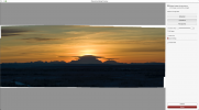
. Winds aloft was pretty high, so we got these fabulous lenticular clouds (somebody correct me if I'm wrong there) over Denali and the adjacent mountain..which is named...?? We still have blue in the sky too! And look at the blocky texture to the horizon, particularly on the right third of the horizon. That's not a lens failing or anything. It's atmospheric distortion and it's really exciting to see. It doesn't last long and I was quite nervous to get the Mavic 3 up quickly when I saw how far the sunset had gone. I didn't even have time to berate myself for not keeping an eye out. As to the composition of the photo, I don't normally put a subject in the middle of a frame, nor allow the horizon to be on or even near the center of the frame but I like this as it is. This image is the totality of the 40 images and I don't want to crop anything out. Since anyone reading this far is a geek, I'm going to include a shot of the preview screen before cropping the panorama and exporting it. It is a Lightroom screen grab. n the second shot below you can see the white edges where I did not hold the camera perfectly steady horizontally as I panned to manually shoot the pano but for me that wasn't too bad. You can see that not much was lost which happens if you don't move the camera laterally with precision when panning for the pano. Panning for the pano. Hah . Back to the discussion of the image, it's tempting to crop half of the dark bottom out and honestly I think compositionally (if that's a word) it makes sense. I think there is too much dark below the horizon and the image would be stronger if I cut some off the bottom but I'm leaving it all in. What do you think? About any of this ? I like sunsets and clouds..and Denali...and blues and golds and atmospheric cool stuff...so I'm biased LOL.
. Winds aloft was pretty high, so we got these fabulous lenticular clouds (somebody correct me if I'm wrong there) over Denali and the adjacent mountain..which is named...?? We still have blue in the sky too! And look at the blocky texture to the horizon, particularly on the right third of the horizon. That's not a lens failing or anything. It's atmospheric distortion and it's really exciting to see. It doesn't last long and I was quite nervous to get the Mavic 3 up quickly when I saw how far the sunset had gone. I didn't even have time to berate myself for not keeping an eye out. As to the composition of the photo, I don't normally put a subject in the middle of a frame, nor allow the horizon to be on or even near the center of the frame but I like this as it is. This image is the totality of the 40 images and I don't want to crop anything out. Since anyone reading this far is a geek, I'm going to include a shot of the preview screen before cropping the panorama and exporting it. It is a Lightroom screen grab. n the second shot below you can see the white edges where I did not hold the camera perfectly steady horizontally as I panned to manually shoot the pano but for me that wasn't too bad. You can see that not much was lost which happens if you don't move the camera laterally with precision when panning for the pano. Panning for the pano. Hah . Back to the discussion of the image, it's tempting to crop half of the dark bottom out and honestly I think compositionally (if that's a word) it makes sense. I think there is too much dark below the horizon and the image would be stronger if I cut some off the bottom but I'm leaving it all in. What do you think? About any of this ? I like sunsets and clouds..and Denali...and blues and golds and atmospheric cool stuff...so I'm biased LOL.Attachments
Last edited:


