DJI Mavic, Air and Mini Drones
Friendly, Helpful & Knowledgeable Community
Join Us Now

Mavic Air never returned

How silly of me to forget this fact. The drone MP2 does obviously know the wind speed at all times since on windy days it warns me with "High Wind Warning". At least on my smart controller. Whether that calculation comes from the smart controller or the drone brain I do not know. As I recall, that warning is accompanied with a 'limit flight time" or some such message, I don't claim to be an expert on this so I am trying to think logically that if the drone smart controller reads battery voltage which measures remaining flight time based on numerous parameters such as batt drain rate, distance from home and the fact that an RTH message and auto RTH accompanied with the "high wind alert" that there must be some kind of calculation which considers wind as one of it's parameters for calculation of RTH. The drone is constantly doing the math for position doing a time and distance calculation for successful return to home. Or maybe the "high wind alert" is just a measure of tilt of the drone? If so there goes my logic. Feel free to correct my logic please. BTW, has the drone owner of this thread topic had any success in finding her lost drone? Hope so. When in doubt, bail out! Perhaps a parachute which deploys in the event of total battery drain resulting in loss of control that deploys to save your drone would be a potential upgrade just like some small airplanes have? :)
 
Or maybe the "high wind alert" is just a measure of tilt of the drone?
That's about all it is.
If the software calculates a wind speed of>7 metres/sec (15.5 mph, from a combination of the drone's speed, tilt and roll data, you get that warning.
Perhaps a parachute which deploys in the event of total battery drain resulting in loss of control that deploys to save your drone would be a potential upgrade just like some small airplanes have? :)
The drone won't keep flying until the battery runs out.
On the battery reaching Critical Low Voltage, the drone enters autolanding to prevent a fall-from-the-sky incident.
That has a similar effect to a parachute, without the cost or weight penalty.
 
Are you assuming that people always make straight line flights out and back?
How would you calculate for winds that are at an angle to the flight path?
Here's a flight I did last week that involved significant winds.
i-NbfpLn2-L.jpg

How simple would it be to program the drone to keep track of the wind data for a flight like this and calculate how the return would be affected by wind?
It's a lot easier for it to calculate RTH battery requirements based on distance (and probably a small safety factor) and leave the flyer to do the extra calculating for anything more than a simple still air flight.


If you are saying that you've observed the indicated height on screen drift over the time of a flight, that's common and normal with a barometric sensor used to measure height.
GPS is not used to establish altitude, and hovering won't make any difference.
Thank you. Nice stiletto pattern btw. Looks like the boot of Italy. So if I hovered the drone instead of flying it around for the same amount of time that I could observe the drone altitude indication going up and down in hover? Interesting but I'm not going to do that just to find out. If I move my smart controller up/down in elevation by driving around in hilly terrain while flying the drone will that cause the drone altitude indication to change if the drone is hovering? I assume not but I'm also not going to try that either for now. I'll report back if I do with results.
 
That's about all it is.
If the software calculates a wind speed of>7 metres/sec (15.5 mph, from a combination of the drone's speed, tilt and roll data, you get that warning.

The drone won't keep flying until the battery runs out.
On the battery reaching Critical Low Voltage, the drone enters autolanding to prevent a fall-from-the-sky incident.
That has a similar effect to a parachute, without the cost or weight penalty.
Oh, I thought you could override the auto land? Thanks.
 
So if I hovered the drone instead of flying it around for the same amount of time that I could observe the drone altitude indication going up and down in hover? Interesting but I'm not going to do that just to find out.
Just look at some of your flight records from past flights.
It's not unusual for the height at the end of the flight to be +/-10 ft or more even though you land at the same point as the launch.
If I move my smart controller up/down in elevation by driving around in hilly terrain while flying the drone will that cause the drone altitude indication to change if the drone is hovering?
The height you see on the screen is the height of the drone relative to where it was launched.
What you do with the controller during flight won't have any effect on it.
 
... The drone MP2 does obviously know the wind speed at all times since on windy days it warns me with "High Wind Warning".
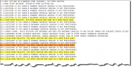
Dug down a bit in one of my own Mavic Air 1 DAT logs to see what I could find regarding wind warning triggers & what happens around the time for those warnings.

The Mavic Air 1 have a different way of handling the relationship between tilt angel, flight mode & ground speed ... even though it's in ordinary P-mode which have a specified max tilt angle of 25 degrees & a max ground speed of 8m/s ... the flight controller will utilize tilt angels from the Sport mode automatically (Sport will go to max 35 degrees) in order to maintain those 8m/s. Some of the newer models also do this but not all.

During this flight I got 5 wind warnings in total ... all of them is color marked here in the TXT log message stream.

(Click on all pics & charts below to make them larger)
1646491726605.png
I looked closer into the DAT log for the one marked in orange coming at 321,1sec into the flight ... there I was flying with a total head wind with only max elevator in P-mode.

My guess is that the wind warning is calculated out from the crafts tilt angel, the achieved ground speed & on top of this some kind of timing or delay.

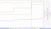
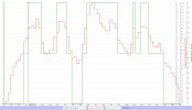
In the DAT log we have wind velocity values (red graph) but also a data signal about a velocity level (green graph). Every time a wind warning gets issued on the app screen this velocity level goes to value 2.

Have in the chart below lined up the chart marker at approx 329sec when the velocity level goes to 2 ... in the TXT logs message stream the wind warning is said to come at 321sec (orange marked occasion above). In that moment the used tilt angle (blue graph) have started to enter Sport mode territory ... meaning exceeding the P-mode's 25 degrees, this to be able to maintain those for P-mode max 8m/s ground speed (purple graph).

1646491810524.png

Can add that the wind calculations from Airdata.com are in the same ballpark as those in the DAT log ... here below what Airdata says about wind velocity around the moment of the orange marked wind warning ( compare with the red graph above).

1646493821067.png

And here the whole flight with all the five velocity level 2 values (green graph) which rather well correspond in time to when wind warnings gets issued in the app according to the TXT log message stream above ... chart marker at 100sec when the green velocity lever goes to 2 for the first time ... and in the TXT log message stream the first wind warning comes in at 99,1sec.

The fact that the timing between the TXT & DAT log doesn't line up exactly aren't anything odd ... the time axis usually differ some between those log types.

1646492884196.png
 
Last edited:

DJI Drone Deals

New Threads

Forum statistics

Threads
134,575
Messages
1,596,437
Members
163,076
Latest member
thelelans
Want to Remove this Ad? Simply login or create a free account