You have to make sure that the wifi in the RC is connected to a hotspot (your phone?). To get to that page, with your drone & RC powered on and connected, swipe down twice from the very top of the screen:

This will bring up the "Control Panel" screen:

Click on the Wifi button. That will bring up this screen:

Scroll down to "Add network".

And add your phone's Hotspot network name (SSID) & password.

Once that is done, your RC will have access to the street maps.
If you have the compass up on the lower-left of your screen:

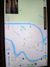
You need to change this to the map display. Do this by tapping the little circle in the lower-right corner of that compass box. That will switch to the map display:

Tap the little map screen to make it full-screen, then zoom in by using two fingers and spread your fingers apart while touching the screen. Repeat until you get the desired zoom level:

The RC will cache the maps in that general area. Once they are there, they will be resident and you won't need to do this again for that area. When you go to take off, the RC will turn off the wifi connection so it doesn't interfere with the control of the aircraft. If you need to login to wifi again, you will need to land, and start at #1 again.