DJI Mavic, Air and Mini Drones
Friendly, Helpful & Knowledgeable Community
Join Us Now

Mavic Mini Blown away

My estimation is as follows. Autolanding should have started when the battery level hit 5% ...
Just a smaller correction here ... the low battery autoland threshold is height dependent & can be read off from the log by the signal SMART_BATTERY:landbattery. In the end of the log when the Mini was at 86,2m above HP that level was 8%, the only thing that could have changed that to 5% (which is the lowest for the Mini) is if it started to suffer from a uncommanded descent & ended up at a lower height.

1604418062609.png
 
Hey!

Let me start off by saying it was a bonehead move for me to be flying today because of heavy wind gusts and also taking off on a less than 100% battery.

When I took off, it wasn't long before the Mavic Mini started drifting away from the home point. I tried to fly it back to no avail, it kept on drifting.

I guess overall what i really want to know is where it ended up. The last reading had it at about 200+ feet. I'm not sure if it started landing at that point or continued to drift away.

I have uploaded the .TXT file is there anything else you would need to help track where the drone may have ended up or what went wrong? First time with this issue. Thanks


I took a fine tip permanent marker and wrote my phone number on the bottom of my drone. One never knows.
 
  • Like
Reactions: BJMSG06 and Capt KO
Although it was in Sport Mode, his Mini was only pitching forward 10° most of the time when it should have been pitching 20°-30°, so it couldn't achieve proper Sport Mode speed and deal with the wind.
Thanks for the pitch information. I will definitely consider that non the future. As I said I trying to import on my interpretations of logs and the feed back is very helpful.
 
Just a smaller correction here ... the low battery autoland threshold is height dependent & can be read off from the log by the signal SMART_BATTERY:landbattery. In the end of the log when the Mini was at 86,2m above HP that level was 8%, the only thing that could have changed that to 5% (which is the lowest for the Mini) is if it started to suffer from a uncommanded descent & ended up at a lower height.

View attachment 116461
Thanks for robust graph. What software are you using? Do you know if there is an online or Mac version.
 
  • Like
Reactions: JohnLietzke
I'm using the PC version of CsvView made by the forum member Budwalker ... download it here (you have a MAC version also) --> CsvView Downloads
Then I recommend reading through this threads first post compiled by forum member sar104 --> Mavic Flight Log Retrieval and Analysis Guide
Thank you. I am already using it and DatCon. The Mavic Air 2 and Mini data from the aircraft is still encrypted and no key has been made available yet. I just need to get better at scaling and setting up the data visualizations. Again, thank you for the information.
 
JohnLietzke, for what it is worth if you open the item named "empty" in the 'menus' on the front page of csvview you can put together your own set of graphs.
 
Hey!

Let me start off by saying it was a bonehead move for me to be flying today because of heavy wind gusts and also taking off on a less than 100% battery.

When I took off, it wasn't long before the Mavic Mini started drifting away from the home point. I tried to fly it back to no avail, it kept on drifting.

I guess overall what i really want to know is where it ended up. The last reading had it at about 200+ feet. I'm not sure if it started landing at that point or continued to drift away.

I have uploaded the .TXT file is there anything else you would need to help track where the drone may have ended up or what went wrong? First time with this issue. Thanks
 
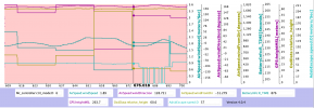
With a drift speed in the end of the log of approx 2-4m/s the search area will be fairly long stretched. When the log ends you still had 11% battery left until low battery autoland which interpolated gives approx 120sec of further drift at present height. We also need to count in the big ground level difference comparing to HP, starting just where the first calculated low battery autoland distance is. At HP the ASL is 69m but further away in the drift direction it is ASL15. This means that the height above ground differs from 86m to 140m ... which of course regulate how long the Mini can drift during the landing. The drift direction was fairly constant during the earlier flight ... came to a conclusion that a difference in tilt direction of 5 degrees can be enough ... that gives the 2 different drift direction. In this we also have another unknown parameter ... how behaved the wind closer to ground, but further away above the lowland ... did the wind follow the ground or became the ground downhill in lee.

And as pointed out in earlier posts, the Mini couldn't maintain a pitch according to spec ... this could have developed to a uncommanded descent much earlier ...

The closest touch down distance is somewhat the same as @boblui calculated ... but due to the big ground level difference it could have continued to drift. Have marked all 4 corner with their GPS positions ... but as you see, the area is rather long and full of taller objects. If you're going to carry out a search I would start from the closest side. But it will be like finding a needle in the haystack unfortunately.

View attachment 116451

In this pic the difference in ground height is visible ...

View attachment 116460
Hey!

Let me start off by saying it was a bonehead move for me to be flying today because of heavy wind gusts and also taking off on a less than 100% battery.

When I took off, it wasn't long before the Mavic Mini started drifting away from the home point. I tried to fly it back to no avail, it kept on drifting.

I guess overall what i really want to know is where it ended up. The last reading had it at about 200+ feet. I'm not sure if it started landing at that point or continued to drift away.

I have uploaded the .TXT file is there anything else you would need to help track where the drone may have ended up or what went wrong? First time with this issue. Thanks
I have a label on mine with “Reward if found” and my Phone Number just in case this happens! Does not guarantee it’s return but it’s worth a shot!
 
  • Like
Reactions: BJMSG06 and Capt KO
Agree with others that marking your drone with Ph# (+ regs # if available) is the best chance of recovery, when lost. Wind is your enemy and increases with height, set RTH as low as possible for the terrain. The new mini firmware is a lifesaver. Safer and more enjoyable flight.
Good luck.
 
  • Like
Reactions: BJMSG06
There were two fatal problems that caused the loss of your Mini.
1. You showed no awareness of the wind issue or how to deal with it.
2. Your Mini was still running very old firmware Version 1.0.244 which was flaky.
Early on many Minis were lost because their Minis would not maintain proper pitch angle to fly at full speed.
Version 1.0.5 fixed this.

For most of your flight, your Mini's pitch angle was around -10° even in Sport Mode and the speed was not proper Sport Mode speed.
For only a couple of short periods during the flight the pitch angle was what it should be and the Mini made headway against the wind.
There's a good example at 4:54, but it only lasted 6 seconds.

At the end of the flight the battery was being burnt at approx 1% each 12 seconds.
On losing signal, it will have gone back to 300 ft and attempted to RTH.
It will have been blown backwards at approximately 5 mph for another 2.5 minutes before descending due to critically low battery.

It's not possible to give a precise location for where it came down but a rough estimate puts it 100-1700 ft further downwind.
Very strange, the latest logs show that my mavic mini also has a FW version 1.0.244! I've never downgraded to a lower version.
 

Attachments

  • DJIFlightRecord_2020-09-10_[15-03-42].txt
    1.5 MB · Views: 6
  • DJIFlightRecord_2020-10-19_[16-20-59].txt
    541 KB · Views: 2
Have you ever updated the firmware?
Yes, when i bought the mini, FW was 1.0.4, so i updated it to 1.0.5.
From the DJIFlightRecord_2020-09-10, CSView shows it correctly (1.0.5)...

DJIFlightRecord_2020-10-19 ---> 1.0.244. Meanwhile, DJI Fly App shows FW 1.0.5.

I'm a bit confused
 
Thank you all for your comprehensive help!

Using the @slup map I did a walk through today checking out all terrain that was visible and that i had access too. It is truly finding a needle in a haystack, it can be anywhere. I originally checked the yard right below the last recorded location was and i thought that was a needle in a haystack so searching half a neighborhood is out of the question haha. I’ll give it about 2 more searches, i plan to check the forest area tomorrow.

I can get over the loss of the drone but it would be cool to have the SD card back. For some reason the recording of last flight was not saved in the DJI fly app album. Any other way to access that?

I know now to never trust those high winds. Also, i think it’s a great idea to write a contact number/offer a reward if found on drone just in case.
 
  • Like
Reactions: Capt KO
Lycus Tech Mavic Air 3 Case

DJI Drone Deals

New Threads

Forum statistics

Threads
131,057
Messages
1,559,372
Members
160,037
Latest member
WonkyBroxy