

3 years ago, I tried flying the MV but was stopped by the Navaho tribal police and told that ALL of MV is a "NO DRONE ZONE'. Can you tell me where you launched from? I'm leaving tomorrow to go there.

You are using an out of date browser. It may not display this or other websites correctly.
You should upgrade or use an alternative browser.
You should upgrade or use an alternative browser.
2 Pro Monument Valley
- Thread starter MPone
- Start date

CalOldBlue
Well-Known Member
WHAT! THIS WAS A TOTALLY ILLEGAL FLIGHT OVER SOVEREIGN NATIVE AMERICAN TERRITORY! Unless he had a paid commercial permit from the Navajo Nation, you should not ever ever ever condone this sort of behavior! Tell me I'm wrong.View attachment 137019So it looks like the park services are in Arizona, and the valley is showing to be at the border. It is academic anyway. What counts is where you shot it from , and the flights were gorgeous. I definitely think you would have to fly stealth there. Don't ask permission. It is all Native land.
The music is Born2Beats.Very Beautiful. Is that Carlos N. playing flute? Godspeed, Droniac
1/60sec, F4, ND8, DLog-M, Davinci Resolve 17 editing software.Great video..what camera settings did you use?
As far as I know, yes. I used the B4UFLY app to check before flight. This area is near to Mexican hat and not inside the MV park. Just beside US163.Is it legal to fly here?
Thanks for watching and compliments.I live 75 miles from Monument Valley and have been there often, but have never felt free to fly my drone there. I have many still camera photos of the area including the rare times when it is covered with snow.
Your use of Native American flute music is a very nice addition to a gorgeous video.
Video was filmed in Utah near to Mexican Hat.Beautiful video, and a great soundtrack - suits it perfectly.
In regards to where Monument valley is, it straddles the border of Utah and Arizona but the majority of the locations in this video are in Utah. The opening shot of that large formation with two smaller ones off to the left - the large one is Brigham's Tomb and the smaller is Stagecoach. The drone is (approximately) 3.4 miles north of the Utah Arizona border and he is shooting looking due south.
View attachment 137017View attachment 137018
View attachment 137020
Good for you. Always live life to the max.You may be old but so am I and you are never too old to travel unless you have a disability that prevents travel. At age 83 I just completed a 3 week African Safari to Tanzania and Kenya. The safari vehicle's entry was a 4 foot off the ground step. I am planning future travel as long as my state of health permits.
Always a pleasure to share beautiful sites.Awesome, thanks for sharing!
I droned near Mexican Hat by US163 roadside. You probably droned inside the park where I’m sure it’s prohibited. Use the B4UFLY app to check for restrictions. It will tell you good for flight or not.3 years ago, I tried flying the MV but was stopped by the Navaho tribal police and told that ALL of MV is a "NO DRONE ZONE'. Can you tell me where you launched from? I'm leaving tomorrow to go there.
CalOldBlue
Well-Known Member
Anything on US163 south of the San Juan River is on Navajo Territory, where drone use is prohibited.As far as I know, yes. I used the B4UFLY app to check before flight. This area is near to Mexican hat and not inside the MV park. Just beside US163.
B4UFLY does not cover local regulations: state, county, city, park district, or Native American Territory. You must do your own research.
If you launched and landed from a federal highway (or the easement on either side) you are probably technically legal, but it remains a disrespectful act and you may get hassled by a local cop.
Good for you Dale, my son-in law says he is sending me to space when I turn 80. I said wait until i'm 91 to beat William Shatner's record, but that's 20 years from now. You could do it in 8. Of course by then someone 100 years old will probably be there. Might just as well go at 80 when the price drops.You may be old but so am I and you are never too old to travel unless you have a disability that prevents travel. At age 83 I just completed a 3 week African Safari to Tanzania and Kenya. The safari vehicle's entry was a 4 foot off the ground step. I am planning future travel as long as my state of health permits.
We’ll it’s too bad if the B4UFLY app is not comprehensive enough. And if droning act is disrespectful then the Navajo nation should also ban all tourists trodding in the reservation also.Anything on US163 south of the San Juan River is on Navajo Territory, where drone use is prohibited.
B4UFLY does not cover local regulations: state, county, city, park district, or Native American Territory. You must do your own research.
If you launched and landed from a federal highway (or the easement on either side) you are probably technically legal, but it remains a disrespectful act and you may get hassled by a local cop.
Dozza88
Well-Known Member
Bryan L
Well-Known Member
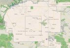
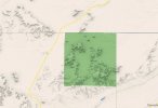
I like going to the source. Map 1 shows most of the Navajo Reservation. Map 2 drills in closer to the area in question. The darker green square is the Tribal Park encompassing Monument Valley. So the flight did not take place "in" Monument Valley.
It did however, take place on Tribal Lands. So I'm sure the pilot complied with the Navajo Nation Government Unmanned Aerial Vehicles Policy dated Dec. 19, 2018,, Paragraph 4.4 which states "All drone or other UAV flights -- except those performed or conducted by the Navajo Nation's Division of Public Safety ("DPS") and other first-responders to emergencies, incidents, or recognized exigencies -- shall require a flight plan approved by the NDOT pursuant to a NDOT Drone Flight Plan Approval Form having been properly submitted to the NDOT. " There's more, like the requirement that all UAV pilots must be accompanies by an "authorized and appropriately-trained visual observer...' and so on.
All this is available at https://navajodot.org/drone which is where you can find the appropriate regulations and get the permit application.
So was the pilot legal? So far as I've been able to determine, if he was parked on the side of the road which has easement, then "yes". Leave that easement (on say, a side road?) and it is an unqualified "NO". I was disturbed by his flippant dismissal of what the Navajo might consider 'disrespectful' (and 'disrespectful' is probably a correct description from my brief research). So much for the feelings of others, eh? Gotta tell 'ya Mpone, that comes across as a "I do what I want and if you don't like it, tough!" attitude. Just sayin'. A large part of the job description of the Navajo Nation Police is watching out for outsiders looting archeological and sacred sites. They're tired of it and I don't blame them.
I find it interesting that B4UFLY ignores Tribal Lands, but CalOldBlue summed up the purpose of B4UFLY quite nicely. I do know that I never take a single source answer if I'm flying in a new area. A little extra research rarely costs anything.
But I did love the colors and light. It's a beautiful place.
Attachments
CalOldBlue
Well-Known Member
We’ll it’s too bad if the B4UFLY app is not comprehensive enough. And if droning act is disrespectful then the Navajo nation should also ban all tourists trodding in the reservation also.
State and Local Drone Rules
B4UFLY shows airspace rules provided by FAA data sources. B4UFLY does not include all local rules which may affect your planned operation – including your ability to land and take off your aircraft from certain areas.While the FAA is the sole regulator of the National Airspace System and governs aircraft operations once airborne, entities such as cities, states, parks, and private landowners may regulate your ability to land and take off your aircraft from certain locations. Please make yourself aware of any local rules prior to your planned operation.
Read our recent blog to learn more about drone operations in state parks.

So if a local park district chooses to ban drones, they also must, by your logic, ban 'tourists trodding' inside the park too? wow
Thanks for all the information. Based on your facts, I'm glad my drone flight is within legal limits. I launched on the roadside of US163.I like going to the source. Map 1 shows most of the Navajo Reservation. Map 2 drills in closer to the area in question. The darker green square is the Tribal Park encompassing Monument Valley. So the flight did not take place "in" Monument Valley.
It did however, take place on Tribal Lands. So I'm sure the pilot complied with the Navajo Nation Government Unmanned Aerial Vehicles Policy dated Dec. 19, 2018,, Paragraph 4.4 which states "All drone or other UAV flights -- except those performed or conducted by the Navajo Nation's Division of Public Safety ("DPS") and other first-responders to emergencies, incidents, or recognized exigencies -- shall require a flight plan approved by the NDOT pursuant to a NDOT Drone Flight Plan Approval Form having been properly submitted to the NDOT. " There's more, like the requirement that all UAV pilots must be accompanies by an "authorized and appropriately-trained visual observer...' and so on.
All this is available at https://navajodot.org/drone which is where you can find the appropriate regulations and get the permit application.
So was the pilot legal? So far as I've been able to determine, if he was parked on the side of the road which has easement, then "yes". Leave that easement (on say, a side road?) and it is an unqualified "NO". I was disturbed by his flippant dismissal of what the Navajo might consider 'disrespectful' (and 'disrespectful' is probably a correct description from my brief research). So much for the feelings of others, eh? Gotta tell 'ya Mpone, that comes across as a "I do what I want and if you don't like it, tough!" attitude. Just sayin'. A large part of the job description of the Navajo Nation Police is watching out for outsiders looting archeological and sacred sites. They're tired of it and I don't blame them.
I find it interesting that B4UFLY ignores Tribal Lands, but CalOldBlue summed up the purpose of B4UFLY quite nicely. I do know that I never take a single source answer if I'm flying in a new area. A little extra research rarely costs anything.
But I did love the colors and light. It's a beautiful place.
Similar threads
- Replies
- 6
- Views
- 443
- Replies
- 5
- Views
- 658
- Replies
- 19
- Views
- 905
- Replies
- 5
- Views
- 1K
- Replies
- 4
- Views
- 1K


DJI Drone Deals
New Threads
-

-

-

-
-
Lost drone: possible crash due to lost signal?
- Started by fharrihill
- Replies: 6
Members online
Total: 4,876 (members: 13, guests: 4,863)
Forum statistics
