DJI Mavic, Air and Mini Drones
Friendly, Helpful & Knowledgeable Community
Join Us Now

Need clarification for flying

MrCalvano

Member
Joined
Feb 23, 2021
Messages
11
Reactions
21
Age
63
Location
Canada
Please see attached image From the NAV drone app. Can anyone tell me. Do I still need permission to fly?
 

Attachments

  • 4A07070B-2653-4C3D-9088-149677057050.png
    4A07070B-2653-4C3D-9088-149677057050.png
    473.8 KB · Views: 125
  • Like
Reactions: Rowder
Mr Calvano

I am not familiar with NAV app, but in Aloft and other apps, a Warning is informing you there is a restricted area nearby and don't accidentally fly into it.

You didn't have any replies, so I thought I'd jump in... I'm sure others on here more familiar with NAV app will point you in the right direction.

Be well, and Fly Safely.

Joe
Thank you.
The NAV drone. Says. …”do not operate a drone in a manner that will interfere “. So I’ll take it as flying responsibly.
 
  • Like
Reactions: Desert Sands
Please see attached image From the NAV drone app. Can anyone tell me. Do I still need permission to fly?

Keep in mind that those apphttps://skyvector.com/s are just interpreting the federal regulations regarding airspace. The PIC is still responsible, no matter what the app says.

Here's a clipping from a sectional chart for the area. It looks like you're in a cluster of seaplane bases and close to the Muskoka airport, what would be a Class E airport in the U.S. I'm not at all familiar with Canada's regs, so I won't venture an opinion on whether you can legally fly at the blue dot you plotted. But maybe this will help you sort it out.

This clipping came from a great sectional chart service online at SkyVector: Flight Planning / Aeronautical Charts. It's primarily for the U.S. but covers parts of southern Canada, too.

port.carling.sectional.jpg
 
@MrCalvano welcome to drone flight in Canada, you can fly in the yellow but this site gives a bit more information :

Nav Canada drone map

The relevant text is :

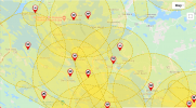
Areas filled with yellow require additional caution due to other air traffic.

Clicking on a yellow circle gives you more detail
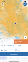
Basics:

Aerodrome. Drone operations are permitted within the 3 nautical mile zone indicated by the yellow filled circle. Caution is advised, however, due to potential seaplane traffic. Operations when other aircraft are present are strongly discouraged.

Details:

901.47(1) of the Canadian Aviation Regulations states:

"No pilot shall operate a remotely piloted aircraft at or near an aerodrome that is listed in the Canada Flight Supplement or the Water Aerodrome Supplement in a manner that could interfere with an aircraft operating in the established traffic pattern."

The yellow shape on the map shows the most likely areas where aircraft traffic patterns may occur around this aerodrome. Operating in this area is permitted, but not recommended. Drone pilots operating in these areas need to exercise additional caution and vigilance in watching for aircraft traffic.

If you chose to fly in this area and see other aircraft operating it is recommended to land, stop flying, and reassess the situation. If you notice regular aircraft activities here it is recommended to contact the aerodrome operator to better understand the local traffic patterns and to coordinate your operations.


Your problem is they may only be occasionally use floatplane docks or they be very active. The only way to know is to observe air traffic. And even then if it is like BC they can literally come out of nowhere over the trees heading for the lake.
 
Keep in mind that those apphttps://skyvector.com/s are just interpreting the federal regulations regarding airspace. The PIC is still responsible, no matter what the app says.

Here's a clipping from a sectional chart for the area. It looks like you're in a cluster of seaplane bases and close to the Muskoka airport, what would be a Class E airport in the U.S. I'm not at all familiar with Canada's regs, so I won't venture an opinion on whether you can legally fly at the blue dot you plotted. But maybe this will help you sort it out.

This clipping came from a great sectional chart service online at SkyVector: Flight Planning / Aeronautical Charts. It's primarily for the U.S. but covers parts of southern Canada, too.

View attachment 133180
Thank you
 
Please see attached image From the NAV drone app. Can anyone tell me. Do I still need permission to fly?
Best to look at an FAA section map of that area if you want to see what is in that area. There are many no fly zones so learning the FAA rules is important. If it is near an airport for instance you will need to unlock your drone for that specific radius around it. DJI has an unlocking website with instructions. If you study for the FAA part 107 license you will learn a lot about reading FAA charts. Even if you don't take the final test it's worth learning the material
 
@LA 2020 rules are very strange up here in Canada, and where @MrCalvano is in Ontario there seem to to be a ton of float plane docks. It is no uncommon, and rarely a hard no fly but rather they expect common sense. The recommend not flying, but it really depends on the air traffic.

National and Provincial parks on the the other hand are no fly but not marked, we need to actually know that.
 
According to the Airmap app, there are 8 advisories; 3 seaplane bases and 5 airports covering the area in question. In the lower 48, I would go to LAANC and request a variance to fly. I don't know the process in the Great White North. BTW: Is the Dudley as in Dudley Dooright?
 

Attachments

  • PortCarling-Dudley.jpg
    PortCarling-Dudley.jpg
    109.3 KB · Views: 2
Please see attached image From the NAV drone app. Can anyone tell me. Do I still need permission to fly?
That area is a complete mess. It's as if there is an aerodrome every 200m. I suspect it's all the seaplanes that service the resorts and the wealthy.

I checked my DJI app and Transport Canada's interactive map and they say, "Aerodrome: Drone operations are permitted within the 3 nautical mile zone indicated by the yellow filled circle. Caution is advised, however, due to potential seaplane traffic. Operations when other aircraft are present are strongly discouraged." I posted the TC map for you, centered on Port Carling.

So, it seems you are allowed but I'd (a) be aware, (b) keep the aircraft low, (c) have my license handy if challenged, and (d) maybe turn on AirSense as a backup.
 

Attachments

  • Aerodrome - Port Carling.png
    Aerodrome - Port Carling.png
    417.4 KB · Views: 1
Just check the NOTAMs. I fly all the time up North and each lake is considered an Aerodrome.
 
Lycus Tech Mavic Air 3 Case

DJI Drone Deals

New Threads

Forum statistics

Threads
131,141
Messages
1,560,305
Members
160,110
Latest member
BluMav