DJI Mavic, Air and Mini Drones
Friendly, Helpful & Knowledgeable Community
Join Us Now

Need help calculating last GPS Mavic Mini

MP010

Active Member
Joined
Jul 27, 2021
Messages
33
Reactions
8
Age
31
Location
rotterdam
Hi,

I bought a drone from the money (inheritance) of my grandmother to record memories. However I am very sad ? now because I lost my drone in a potato field (see pics) because it blew away and the RTH did not work (my own faul) Also the last GPS is from 50meter above the ground so therefore I want to calculate where my drone landed. I am not into maths at all so perhaps some bright person can help me with the analysis. The flight logs are attached. If I know the GPS coordinates of where the drone landed I am still able to find my drone. Because now I already searched for a week and could not find it. Soo frustrating because I know the range isnt that big. It must be possible to find it there…

can somebody analyse my flight logs and calculate where it landed? You would help me tremendously!!!

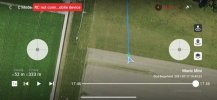
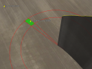
just to give a impression of this place ⬇️☺️
58BB441B-8283-4ED0-9E19-4B6DE264040E.jpg

A4275983-2976-40EA-ADF1-5D3EC9A58518.jpeg
 

Attachments

  • DJIFlightRecord_2021-07-17_[19-49-23].txt
    2.5 MB · Views: 8
Yep ... your drone blew away. The major mistake you did was to have the RTH height set very, very high. That meant that your Mini tried to reach over 500ft when the low battery RTH kicked in. You stopped the ascent by applying negative throttle & lowered the height down to a tad over 300ft but there you let your Mini continue to blow away instead of continue to descend further into lower wind speeds.

When you lost connection & the log ends the Mini is up on 313ft & blowing away with a speed of approx 1,65m/s. The charge level is 12% & the auto land percentage is 8%. Your Mini is consuming approx 1% per 10sec.

All in all the Mini didn't blow so far from where the log ends roughly 90-120m further down wind.

The direction it blow varies a bit & so will the wind speed on the way down ...

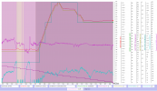
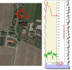
Here the relevant data to make the calculation from the log ...

(Click on the chart to make it larger)
1627428144700.png

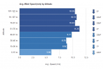
The wind speeds on different altitudes to estimate when on the way down the Mini stop to blow away, seems to be below 50m height ...

1627428210062.png

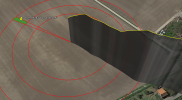
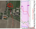
All this gives a approx search area ... 27m long & 10m wide (green colored in the picture below). The GPS position is in the middle of the square ... even though the search area is relative small it will be hard to find a small Mini out in that potato field.

1627428404373.png
 
Yep ... your drone blew away. The major mistake you did was to have the RTH height set very, very high. That meant that your Mini tried to reach over 500ft when the low battery RTH kicked in. You stopped the ascent by applying negative throttle & lowered the height down to a tad over 300ft but there you let your Mini continue to blow away instead of continue to descend further into lower wind speeds.

When you lost connection & the log ends the Mini is up on 313ft & blowing away with a speed of approx 1,65m/s. The charge level is 12% & the auto land percentage is 8%. Your Mini is consuming approx 1% per 10sec.

All in all the Mini didn't blow so far from where the log ends roughly 90-120m further down wind.

The direction it blow varies a bit & so will the wind speed on the way down ...

Here the relevant data to make the calculation from the log ...

(Click on the chart to make it larger)
View attachment 132444

The wind speeds on different altitudes to estimate when on the way down the Mini stop to blow away, seems to be below 50m height ...

View attachment 132445

All this gives a approx search area ... 27m long & 10m wide (green colored in the picture below). The GPS position is in the middle of the square ... even though the search area is relative small it will be hard to find a small Mini out in that potato field.

View attachment 132446
 
Wow! I am very thankful that you took the effort to make this analysis for me. I really appreciate this??

I go to bed now and the first thing I do when I wake up is looking for the drone in that green area you drafted.

I’ll let you know if I find it. Thanks!
 
Well, that's a great analysis and estimated spot to go and search, grab some friends / family to help you, and good luck to you in finding it safely and undamaged.

Try a slow line search where you are all almost shoulder to shoulder, have some sticks to lift potato leaves as you walk slowly through the area.

Report back here as it would be good for people doing the analysis to know if successful or not.
 
Wow! I am very thankful that you took the effort to make this analysis for me. I really appreciate this??

I go to bed now and the first thing I do when I wake up is looking for the drone in that green area you drafted.

I’ll let you know if I find it. Thanks!
@MP010

Due to some unknown error in the tool I used to calculate a probable search area where your Mini could have landed the GPS position was wrong ...

Your Mini had actually already gone into low battery landing before the log ends due to that you lose the connection. Have re-calculated the position based on a horizontal drift speed between 1,7-2,2m/s & a descent speed of 1,9m/s. Being 52m above ground it would have taken 27sec to reach ground ... drifting with the speeds noted above. This meant that your Mini continued between 46-59,5m further down wind. The direction is a estimation out from the earlier drift path.

The difference in drift speed & direction forms a rectangular area 13m long & 8m wide orientated nearly exactly in a north/south direction. The center GPS position is in the picture below.

1627474349842.png


@BudWalker ... something goes wrong when opening a Phantomhelp .csv in CsvView. For this case .txt CsvView misses just over 60 sec from the data that actually are in the log. The full log is drawn out if using a .csv from Airdata.

Test out the attached .txt in post #1 & see if you can recreate the problem ...

This is a PhantomHelp .csv shown in CsvView ...

1627478222195.png

And here the Airdata .csv ...

1627478271621.png
 
Last edited:
@MP010

Due to some unknown error in the tool I used to calculate a probable search area where your Mini could have landed the GPS position was wrong ...

Your Mini had actually already gone into low battery landing before the log ends due to that you lose the connection. Have re-calculated the position based on a horizontal drift speed between 1,7-2,2m/s & a descent speed of 1,9m/s. Being 52m above ground it would have taken 27sec to reach ground ... drifting with the speeds noted above. This meant that your Mini continued between 46-59,5m further down wind. The direction is a estimation out from the earlier drift path.

The difference in drift speed & direction forms a rectangular area 13m long & 8m wide orientated nearly exactly in a north/south direction. The center GPS position is in the picture below.

View attachment 132488


@BudWalker ... something goes wrong when opening a Phantomhelp .csv in CsvView. For this case .txt CsvView misses just over 60 sec from the data that actually are in the log. The full log is drawn out if using a .csv from Airdata.

Test out the attached .txt in post #1 & see if you can recreate the problem ...

This is a PhantomHelp .csv shown in CsvView ...

View attachment 132494

And here the Airdata .csv ...

View attachment 132495
I know what the problem but not exactly how it should be fixed. The online PhantomHelp converter produces a .csv where some of columns treat values >= 1000.0 differently. I don't know about the offline Flight Reader - having a little trouble with it this morning.
@jclarkw
 
  • Like
Reactions: slup
@MP010

Due to some unknown error in the tool I used to calculate a probable search area where your Mini could have landed the GPS position was wrong ...

Your Mini had actually already gone into low battery landing before the log ends due to that you lose the connection. Have re-calculated the position based on a horizontal drift speed between 1,7-2,2m/s & a descent speed of 1,9m/s. Being 52m above ground it would have taken 27sec to reach ground ... drifting with the speeds noted above. This meant that your Mini continued between 46-59,5m further down wind. The direction is a estimation out from the earlier drift path.

The difference in drift speed & direction forms a rectangular area 13m long & 8m wide orientated nearly exactly in a north/south direction. The center GPS position is in the picture below.

View attachment 132488


@BudWalker ... something goes wrong when opening a Phantomhelp .csv in CsvView. For this case .txt CsvView misses just over 60 sec from the data that actually are in the log. The full log is drawn out if using a .csv from Airdata.

Test out the attached .txt in post #1 & see if you can recreate the problem ...

This is a PhantomHelp .csv shown in CsvView ...

View attachment 132494

And here the Airdata .csv ...

View attachment 132495
Oh thats why we couldnt find it haha! Well, that gives me new hope so I wilp search on the new location tommorow. I let you know!

I am looking with the dji mini 2 as well. The new drone helps me with the search as you can often see through the plants. The only problem is that I can not put your GPS coordinates in the DJ Fly app so I can manually fly towards it. Perhaps somebody nows a solution for this as well?

I’ll keep you posted!
 
Lycus Tech Mavic Air 3 Case

DJI Drone Deals

New Threads

Forum statistics

Threads
131,096
Messages
1,559,801
Members
160,079
Latest member
calezu