DJI Mavic, Air and Mini Drones
Friendly, Helpful & Knowledgeable Community
Join Us Now

NEED HELP WITH POI SETTINGS

000

Well-Known Member
Joined
Dec 28, 2020
Messages
67
Reactions
275
Location
botswana
Hello - I have been looking everywhere for an explanation about the settings for POI.
When you pick a POI , you can adjust its altitude but what does that actually mean?

If your flying around a POI and set the altitude of the POI, what does that altitude adjustment actually mean and do?

If your flying a path and just want to look at a POI and set the altitude of the POI, what does that actually mean and do?

If your flying over a POI and set the altitude of the POI, what does that actually mean and do?

Thanks for any help with my question.

Cheers ?
 
Setting the Alt just sets your Max height for the Flight and path of the POI once the POI triggers.

Phantomrain.org;
Gear to fly your Mavic in the Rain and Snow
 
  • Like
Reactions: 000
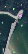
Hello @Phantomrain.org - thanks for that info but I dont think I explained my question right .... The image below shows waypoints (green) at 82ft - the POI (pink) has an altitude of 7ft --- im not understanding what the altitude of the POI in this image is representing. If I were to change that 7ft altitude to 150ft, what would happen ? Why is that POI setting 7ft ?

Screenshot 2021-02-16 at 03.07.04.png

Thanks for any help on this.
 
What app are you using for the Waypoints? With Litchi, the height of the POI will automatically control the gimbal pitch from this waypoint to the next to keep the selected POI in the center of the frame. The POI altitude will be taken into account to determine the gimbal pitch angle.
 
  • Like
Reactions: 000
What app are you using for the Waypoints? With Litchi, the height of the POI will automatically control the gimbal pitch from this waypoint to the next to keep the selected POI in the center of the frame. The POI altitude will be taken into account to determine the gimbal pitch angle.
Hello - Im not using an app yet. The pic is from an app called Maven. Im trying to learn about all of them to see if I really want to use one ... .. So what you have described the altitude you set for the POI is not "really" an altitude, it's "degrees of pitch ?" - On these apps, how do you determine the "altitude" of the POI if you are planning a mission before you fly or is that guess work and fine tune it as you go? -- If (like in the pic above) the POI "altitude" is 7 degrees, I take it that straight down on gimbal pitch is 0 degrees or 0 altitude ? ---- Thanks for your explanation ...
 
The PoI altitude is really the altitude of the Point of Interest, and not the description of an angle.

It is the point in 3D space defined by the two geographical co-ordinates (East-West, North-South), and the one height co-ordinate (Up-Down). The latter is the altitude setting.

In your example, if your PoI were a 70 meter tower, setting the PoI height at 7 meters would help your drone take a film of the queue of people getting into the tower. If you set the PoI height to 70 meters, you would be taking a film of the viewing platform at the top of the tower.

(You could achieve each of these options in a different way: by setting gimbal pitch. However, with PoIs you don't need to do that; the software does it for you.)
 
  • Like
Reactions: Rmcolon and 000
Pictures might help...

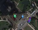
This is a mission with just two waypoints (purple markers) and two Points of Interest (Blue and Green markers):
Two Waypoint Mission.jpg
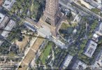
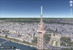
Waypoint 1 focuses on PoI 1; Waypoint 2 focuses on PoI 2.

The view at the beginning of the flight:
View from Waypoint 1.jpg

The view at the end of the flight:
View from Waypoint 2.jpg
The PoIs could have been on top of each other, as could the Waypoints.


[Two notes: (1) this flight would be thoroughly illegal, (2) Litchi and Google Earth are just great together with VLM!]
 
  • Like
Reactions: Rmcolon and 000
The PoI altitude is really the altitude of the Point of Interest, and not the description of an angle.
We recently had a similar discussion while out flying with fellow forum members: Even if the POI is a 10 meter tall statue, a 30-meter POI altitude setting would have the camera focused at an imaginary spot 20 meters above your POI. Depending on your drone altitude and distance from the POI, this 30 meter setting may not even capture the statue.

So with the Eiffel Tower being slightly over 320 meters, the two different POI altitudes have a camera pointed near the top and bottom of the tower (250m & 1m).
 
Last edited:
  • Like
Reactions: 000
@Facherty - @pelagic_one - Thank you both so much for your explanations - makes total sense to me now.
The POI altitude setting is as well determined on the altitude and distance as said by @pelagic_one that the drone is flying relative to the POI ?
So that means that my assumption of the image I posted is wrong -- The waypoint has to be 82 meters (246ft)
and the POI is 7 meters (21ft) - now looking at the image the POI is roughly a two story building.
Would my new assumption be close to being right?
 
The waypoint has to be 82 meters (246ft)
and the POI is 7 meters (21ft) - now looking at the image the POI is roughly a two story building.
Would my new assumption be close to being right?
Yes, assuming about 10ft per building floor, your 21ft POI altitude would have the camera pointed to about center-of-mass of a two-story building.
 
  • Like
Reactions: 000
Lycus Tech Mavic Air 3 Case

DJI Drone Deals

New Threads

Forum statistics

Threads
130,596
Messages
1,554,226
Members
159,602
Latest member
Tenakeetwo