

Kyle76
Well-Known Member
I may be wrong, but I don’t think there’s a hobbyist “version“ different from a pro version of Dronelink, it’s just how you pay and your honesty.

I was in touch with DJI on the subject of mapping apps. They told me that it is up to the mapping apps to create the links. I rhwn contacted DorneDeploy. They told me they are working on it. So, I guess the SDK has been released.You would need to be able to use one of the mapping apps like DroneDeploy to properly fly a grid and capture images at the right places with precise overlaps of 70% or more.
That's not possible with the Mavic Air 2 until DJI release the SDK for the drone to allow 3rd party developers to produce apps that work with the Air 2.
You don't want to hear it but for now, your only option would be to use a different drone.
Just a thought, have you had a look at Hivemapper. Might do the job for you. They offer free for recreation use and a couple of pricing options for commercial use. I have signed up for free use and have just done a flight over a constructed wetlands but haven't processed it yet.So I have the opportunity to earn some money with my MA2 if I can figure out how to fly, image, and create an orthomosaic. Since we can't fly the mission with 3rd party apps, what are my options (besides using a different drone, not an option)? Obviously I'm new to this, and I won't take the missions without a clear path forward to providing a professional result.
So I have the opportunity to earn some money with my MA2 if I can figure out how to fly, image, and create an orthomosaic. Since we can't fly the mission with 3rd party apps, what are my options (besides using a different drone, not an option)? Obviously I'm new to this, and I won't take the missions without a clear path forward to providing a professional result.
I just went to OpenDroneMap. All I see is a wide variety of applications with no clarification. Would like to give members here some clarification?I have been learning to use Open Drone Map. I have experimented with doing manual missions and the results are not good enough to sell as a service. The software, which I paid for the installer and recommend it, is great and will give the results you are looking for, but we will have to wait for some mission planning software for the MA2 before being able to do this with usable results. Here are some good comparisons of the different solutions available.
I went to your link. Here us what popped up. No explanation on what each provides. Can you help?ODM is amazing open source software for 3d models and orthomosaics. I have been using.g it for about 18 months now with my Mavic Pro. It can generate both orthomosaics and 3D Models, exportable to gis and cad platforms, and has a host of other features such as contouring, dem generation etc. It has comparable features to pix4d and agisoft, and best of all its free if you install it yourself, or alternatively if you want to you can at a minimal cost purchase the windows installer! All funds for for the windos installer go straight back into the software development.
All you need is an adequately resourced PC to be able to process the datasets you capture with your drone. I have been using drone deploy to capture the images with my Mavic Pro, but have just upgraded to an Air 2 so I'm currently waiting for Dronedeploy or another third party app to release to support grid mapping for the MA2.
I really recommend you check this out if you interested in creating orthomosaics or 3D models with your drone. There is also a very active community forum who are always ready to help if you ever have issues.
WebODM Drone Software - OpenDroneMap™
A free, user-friendly, extendable application and API for drone image processing. Create maps, point clouds, 3D models and DEMs from aerial images.www.opendronemap.org
Did you click on either of them?I went to your link. Here us what popped up. No explanation on what each provides. Can you help?
View attachment 112422
So I have the opportunity to earn some money with my MA2 if I can figure out how to fly, image, and create an orthomosaic. Since we can't fly the mission with 3rd party apps, what are my options (besides using a different drone, not an option)? Obviously I'm new to this, and I won't take the missions without a clear path forward to providing a professional result.
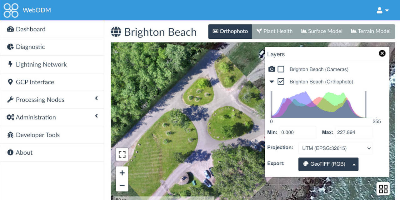
The webodm is the one you want to use. All the software libraries listed below those links are the different open source modules included in ODM. WebODM and ODM are referring to the user interface. The web one is a browser based UI and more then likely the one you want. The ODM is a command line based user interface. I bought the installer and it simplifies the install greatly. The cost also goes to developmentI went to your link. Here us what popped up. No explanation on what each provides. Can you help?
View attachment 112422
I tend NOT to click on links when I do not know where they will take me...and the result/s to be expected. Thnat is a waste of time when I have things to do in which I have a good idea what IO am doing.Did you click on either of them?
What you've done is easy and appropriate for your use but it's making a planar panorama and not an orthophoto.I’ve done a few orthos completely manually, using DJI Go, eyeballing the overlap and grid, then merging the photos with the free Microsoft Image Composite Editor
Although, if it’s a small area, a proper orthophoto is possible from manual flying, if you use something like ODM etc - I’ve done this myself.What you've done is easy and appropriate for your use but it's making a planar panorama and not an orthophoto.
If the OP was asked to professionally create an orthophoto, there's a lot more that goes into an orthophoto.
This explains what an orthophoto is.
An orthophoto is an aerial photograph that has been geometrically corrected or 'ortho-rectified' such that the scale of the photograph is uniform and utilised in the same manner as a map. An ortho-photograph can be used to measure true distances of features within the photograph. Planimetric corrections have been applied to remove lens distortions and optics, camera angle, and differences in elevation (topographic relief) through a process of measuring ground control points to 'tie' the photo to the ground, in a drawing-pin like manner. An orthophoto is an accurate representation of the Earth' s surface. Orthophotos have the benefits of high detail, timely coverage combined with the benefits of a map including uniform scale and true geometry.
So I have the opportunity to earn some money with my MA2 if I can figure out how to fly, image, and create an orthomosaic. Since we can't fly the mission with 3rd party apps, what are my options (besides using a different drone, not an option)? Obviously I'm new to this, and I won't take the missions without a clear path forward to providing a professional result.
I actually use Copterus app on apple with my MA2.So I have the opportunity to earn some money with my MA2 if I can figure out how to fly, image, and create an orthomosaic. Since we can't fly the mission with 3rd party apps, what are my options (besides using a different drone, not an option)? Obviously I'm new to this, and I won't take the missions without a clear path forward to providing a professional result.


We use essential cookies to make this site work, and optional cookies to enhance your experience.
