Yesterday I flew two
out of signal waypoint missions close to our airport. In the first one, I forgot to start recording. How stupid is that? Watching the video from the second one, the drone seemed to not fly the correct waypoint mission. Does anyone know how to get the map of a flight you have flown from the drone? Please let me know. One interesting thing I found out, is there's a small plane airport, right next to the international airport. And it's runway isn't in the red zone. So
you can fly right over the runway. I'll post a picture.
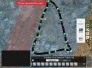
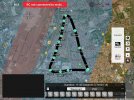
This is the mission I was flying yesterday. You can see by waypoint 6, the little airports runway.
It's not in the red zone.View attachment 159780
The DJI's Red Restricted Zone covers the runway of the Clark International Airport, a runway which it shares with a Philippine Air Force Base!
It is VERY important to realize and understand that DJI's GeoZones do not necessarily reflect what is legal or illegal. Those GeoZones of different colours are merely DJI's effort to prevent liability falling upon themselves. It is up to you, the pilot, to determine whether what you're doing is actually legal.
By self-authorizing your own flight within that Blue Authorization Zone, you are absolving DJI of any liability, as you will have acknowledged and accepted responsibility for your own actions when flying within that zone. You need to be logged in to your validated DJI account in order to complete that self-authorization. That means DJI knows who you are.
Very important! Just because DJI doesn't
prevent you from flying there doesn't mean it is
legal for you to do so. I strongly suspect that flying a drone this close to an active International airport, and even closer to the small Omni Aviation Airport, without authorization from whoever controls that airspace would be just as
illegal in the Philippines as it is everywhere else in the world.
Whether it's legal or not, it's definitely
not smart to be using a waypoint mission to send your drone anywhere beyond the range of your control signal. especially near those airports.
I've had 5 out of signal waypoint flights, so I'm gaining confidence.
You may be gaining confidence that the drone is flying its waypoint route as programmed, and gaining confidence that it will eventually return by itself. However, during the period that it is flying by itself
out of signal range, you have no idea what's happening to it and no possibility of taking corrective action if something goes wrong.
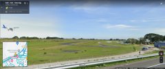
Here's an image from Google Streetview from the highway showing a Cessna on approach to the south end of the runway of the small
Omni Aviation Airport. That airport runs a busy flight school. Aircraft flying out of here are very likely doing right-hand circuit patterns, meaning they turn
away from the International Airport when doing circuits, towards the path of your drone's waypoint route.


