DJI Mavic, Air and Mini Drones
Friendly, Helpful & Knowledgeable Community
Join Us Now

Part 107: Max altitude is 0 AGL due to 1/2 mile from class D airport, can i fly below a 65ft obstruction 250ft to my south without a wavier?

Steve Wells

Active Member
Joined
Nov 26, 2021
Messages
33
Reactions
54
Age
61
Location
Sacramento
Hey guys.

I’d really like to fly in my back yard no higher than 20-30 feet for some vlog work for projects in my own back yard. I live about 1/2 mile from a class D civilian airport. I’m in a 0 MSL area. There is a tree I’ve estimated at 65 ft high about 250 ft closer to the airport than i am.

I do want to fly by the book. Looking at 107.51 it says i can fly +400 feet above any structure within a 400 ft. I recognize this is a bit of hand waiving, but why would it not be ok to say fly less than 50’ MSL since there already a “structure” (tree) 65ft tall within 250 ft of where i want to fly.

Is this legal? If not what are the challenges if i request a ongoing and perpetual part 107 waiver to allow me to fly no more than 50ft strictly above May property they would accept such a waiver?

I started writing the waiver request but then started questioning if it was necessary. Appreciate your comments here guys.


Operation Title: DroneZone submitted authorization to fly in a “zero” grid area from the UAS facility map grid ~1/2 SM west of XXXX Airport Class-D) supporting video/photography documentation and social media.

Responsible Party: Steven xxxx, Remote Pilot Cert xxxxx Issued 10 Dec 2021

Address on file: xxxx

Phone: xxxx

RPIC will also be the responsible party.

Operation Parameters:
  • Start/End date: Perpetual
  • Timeframe: any time.
  • Frequency: unrestricted number of flight operations.
  • Proposed location of flight
    • Xxxxx address
    • Long/Lat: -12x.xxxx, 3y.yyy
    • Airspace: KXXX Class D airspace, approx 2300 ft west of runway XX
    • Radius Over addressed private property only for which the PIC is the owner
  • Maximum Altitude: No higher than 60ft AGL
    • High requested supports CFR 107.43 and is lower than a obstruction (tree) 250ft to the south estimated at 68ft height which has already been factoring into KXXX maned flight operations.
Procedures not included includes preflight, B4UFLY, VLOS, RPIC monitoring airport ATIS preflight and tower during flight, no flights over other people, ADS-B monitored from Drone (mavic3)
 
Last edited:
  • Like
Reactions: LoudThunder
Hey guys.

I’d really like to fly in my back yard no higher than 20-30 feet for some vlog work for projects in my own back yard. I live about 1/2 mile from a class D airport. I’m in a 0 MSL area. There is a tree I’ve estimated at 65 ft high about 250 ft closer to the airport than i am.

I do want to fly by the book. Looking at 107.51 it says i can fly +400 feet above any structure within a 400 ft. I recognize this is a bit of hand waiving, but why would it not be ok to say fly less than 50’ MSL since there already a “structure” (tree) 65ft tall within 250 ft of where i want to fly.

Is this legal? If not what are the changes that if i request a ongoing and perpetual part 107 waiver to allow me to fly no more than 50ft strictly above May property they would accept such a waiver?

I started writing the waiver request but then started questioning if it was necessary. Appreciate your comments here guys.


Operation Title: DroneZone submitted authorization to fly in a “zero” grid area from the UAS facility map grid ~1/2 SM west of XXXX Airport Class-D) supporting video/photography documentation and social media.

Responsible Party: Steven xxxx, Remote Pilot Cert xxxxx Issued 10 Dec 2021

Address on file: xxxx

Phone: xxxx

RPIC will also be the responsible party.

Operation Parameters:
  • Start/End date: Perpetual
  • Timeframe: any time.
  • Frequency: unrestricted number of flight operations.
  • Proposed location of flight
    • Xxxxx address
    • Long/Lat: -12x.xxxx, 3y.yyy
    • Airspace: KXXX Class D airspace, approx 2300 ft west of runway XX
    • Radius Over addressed private property only for which the PIC is the owner
  • Maximum Altitude: No higher than 60ft AGL
    • High requested supports CFR 107.43 and is lower than a obstruction (tree) 250ft to the south estimated at 68ft height which has already been factoring into KXXX maned flight operations.
Procedures not included includes preflight, B4UFLY, VLOS, RPIC monitoring airport ATIS preflight and tower during flight, no flights over other people, ADS-B monitored from Drone (mavic3)
Civil airport or military? Is LAANC available?

I understand that you can request altitude variances though the Aloft app in areas served by LAANC. There's no automated, instant response; it's human reviewed. But it might be a simpler way to get approval.
 
  • Like
Reactions: LoudThunder
Hey guys.

I’d really like to fly in my back yard no higher than 20-30 feet for some vlog work for projects in my own back yard. I live about 1/2 mile from a class D airport. I’m in a 0 MSL area. There is a tree I’ve estimated at 65 ft high about 250 ft closer to the airport than i am.

I do want to fly by the book. Looking at 107.51 it says i can fly +400 feet above any structure within a 400 ft. I recognize this is a bit of hand waiving, but why would it not be ok to say fly less than 50’ MSL since there already a “structure” (tree) 65ft tall within 250 ft of where i want to fly.

Is this legal? If not what are the changes that if i request a ongoing and perpetual part 107 waiver to allow me to fly no more than 50ft strictly above May property they would accept such a waiver?

I started writing the waiver request but then started questioning if it was necessary. Appreciate your comments here guys.


Operation Title: DroneZone submitted authorization to fly in a “zero” grid area from the UAS facility map grid ~1/2 SM west of XXXX Airport Class-D) supporting video/photography documentation and social media.

Responsible Party: Steven xxxx, Remote Pilot Cert xxxxx Issued 10 Dec 2021

Address on file: xxxx

Phone: xxxx

RPIC will also be the responsible party.

Operation Parameters:
  • Start/End date: Perpetual
  • Timeframe: any time.
  • Frequency: unrestricted number of flight operations.
  • Proposed location of flight
    • Xxxxx address
    • Long/Lat: -12x.xxxx, 3y.yyy
    • Airspace: KXXX Class D airspace, approx 2300 ft west of runway XX
    • Radius Over addressed private property only for which the PIC is the owner
  • Maximum Altitude: No higher than 60ft AGL
    • High requested supports CFR 107.43 and is lower than a obstruction (tree) 250ft to the south estimated at 68ft height which has already been factoring into KXXX maned flight operations.
Procedures not included includes preflight, B4UFLY, VLOS, RPIC monitoring airport ATIS preflight and tower during flight, no flights over other people, ADS-B monitored from Drone (mavic3)
The 400 ft from a thing structure doesn’t apply in controlled airspace so you need an airspace authorization or waiver.

I would make sure the area you request is just right above your property. They are much more likely to approve over a small area and mention the tree. I didn’t realize there was even an option for a perpetual authorization. I thought 2 years was the max. It’s not a slam dunk for sure being so close but give it a try and adjust if they deny
 
Hey guys.

Looking at 107.51 it says i can fly +400 feet above any structure within a 400 ft. I recognize this is a bit of hand waiving, but why would it not be ok to say fly less than 50’ MSL since there already a “structure” (tree) 65ft tall within 250 ft of where i want to fly.

When you get LAANC authorization, you will be operating under:

§ 107.41 Operation in certain airspace.
No person may operate a small unmanned aircraft in Class B, Class C, or Class D airspace or within the lateral boundaries of the surface area of Class E airspace designated for an airport unless that person has prior authorization from Air Traffic Control (ATC).

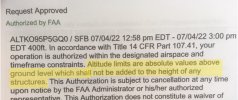
Here is a recent LAANC request I printed off - I've highlighted the relevant part where they specifically state that the height limits are absolute. 107.51 (height over structures) only applies if the entire flight can be conducted in uncontrolled airspace.

AirSpace.jpg
 
  • Like
Reactions: LoudThunder
Hey thanks everyone. Point taken that 107.51 is only for controlled airspace and since I’m in the 0MSL lateral boundaries of a class D airport 107.41 applies which means if i want a waiver i need to request ATC authorization. Automated authorization always fails, so i assume I’ll need to request an authorization through dronezone. @ Pilot did you get authorization through dronezone? How long did authorization take.

As a side comment I’m a little surprised i can’t even fly 5 ft in my living room technically. I guess dealing with the one-off authorizations is less work that refining 107.41 to allow me to fly no higher than an obstruction within the distance i can throw a rock.
 
  • Like
Reactions: LoudThunder
This is a bit of an aside, but the "flying 400ft above structures" is only for man-made structures, so trees don't count. Same with hills. It's strictly above the ground, so you can't fly 400 ft. above a mountain peak within a 400 ft. radius of the peak....just 400ft above the peak itself.
 
Hey thanks everyone. Point taken that 107.51 is only for controlled airspace and since I’m in the 0MSL lateral boundaries of a class D airport 107.41 applies which means if i want a waiver i need to request ATC authorization. Automated authorization always fails, so i assume I’ll need to request an authorization through dronezone. @ Pilot did you get authorization through dronezone? How long did authorization take.

As a side comment I’m a little surprised i can’t even fly 5 ft in my living room technically. I guess dealing with the one-off authorizations is less work that refining 107.41 to allow me to fly no higher than an obstruction within the distance i can throw a rock.
If you are making your LAANC request under as part 107 operations you can make your request through LAANC but it will be for one day at a time. If you want this as a recurring long term authorization, which makes sense in your case, Drone Zone is your better bet but it will take a bit longer. How long will depend solely on the FAA official at the airport in charge of these things. Sometimes few days, sometimes a few weeks. Sometimes they don’t respond at all…

Your living room isn’t part of the National airspace so technically FAA regulations don’t apply and you are free to fly as high and as often as you want there 😉
 
Last edited:
  • Like
Reactions: LoudThunder
@ Pilot did you get authorization through dronezone? How long did authorization take.

As a side comment I’m a little surprised i can’t even fly 5 ft in my living room technically. I guess dealing with the one-off authorizations is less work that refining 107.41 to allow me to fly no higher than an obstruction within the distance i can throw a rock.

If you're asking me, I get my authorizations through LAANC via the Aloft app. On that particular day, I was in a 400 foot grid of the Sandford Class C International Airport and the authorization was instant. I would note that it depends on where you are - inside the airspace, how big an area you want and for how long, but so far I have always gotten immediate clearance.

Inside your home is not the NAS, and FAA has no jurisdiction there but; the problem then becomes, the drone/DJI doesn't know you're inside.
 
  • Like
Reactions: LoudThunder
When you get LAANC authorization, you will be operating under:

§ 107.41 Operation in certain airspace.
No person may operate a small unmanned aircraft in Class B, Class C, or Class D airspace or within the lateral boundaries of the surface area of Class E airspace designated for an airport unless that person has prior authorization from Air Traffic Control (ATC).

Here is a recent LAANC request I printed off - I've highlighted the relevant part where they specifically state that the height limits are absolute. 107.51 (height over structures) only applies if the entire flight can be conducted in uncontrolled airspace.

View attachment 151173
Hummm....there are several Class E and do not understand the blanket statment...Studying for 107 from P.I....
Class E generally at 1,200 and not noted 14,500

E1 Class E1 at and above 14,500 ft MSL

E2 Class E2 designated as a surface area for an airport. This is the ONLY one required authorization.

E3 Class E3 designated as an extension for class C No approval needed.

E4 Class E4 designated as an extension to Class D or Class E. STARTS at 1,200 ft unless otherwise noted. No approval needed.... I fly at the local airport Class E where it starts at 700 feet.
 
  • Like
Reactions: LoudThunder
Hummm....there are several Class E and do not understand the blanket statment...Studying for 107 from P.I....
Class E generally at 1,200 and not noted 14,500

E1 Class E1 at and above 14,500 ft MSL

E2 Class E2 designated as a surface area for an airport. This is the ONLY one required authorization.

E3 Class E3 designated as an extension for class C No approval needed.

E4 Class E4 designated as an extension to Class D or Class E. STARTS at 1,200 ft unless otherwise noted. No approval needed.... I fly at the local airport Class E where it starts at 700 feet.
I’m not exactly sure what you mean because it does say “within the lateral boundaries of the surface area of Class E airspace designated for an airportwhich is the same thing that you just said.
 
If you are making your LAANC request under as part 107 operations you can make your request through LAANC but it will be for one day at a time. If you want this as a recurring long term authorization, which makes sense in your case, Drone Zone is your better bet but it will take a bit longer. How long will depend solely on the FAA official at the airport in charge of these things. Sometimes few days, sometimes a few weeks. Sometimes they don’t respond at all…

Your living room isn’t part of the National airspace so technically FAA regulations don’t apply and you are free to fly as high and as often as you want there 😉
Hi Brett,

I used to have a 2-year COA for my local Class D airspace. I am in a zero grid and got permission to go to 100 ft. But now the airport is covered by LAANC, AND they’ve changed the grid where I am to 200 ft. LAANC works great, but I’m still geofenced and need an OK from DJI to fly. (I have to be in a wifi environment to get that. I’m still a little unsure of the process of transferring the license to the aircraft. Actually, that part is easy - the part I don’t understand is getting it to my Smart Controller - an Android device - while I use my computer or iPhone to request it. But that’s another story.) Anyway, the extra requirement from DJI slows EVERYTHING down, and makes spur-of-the-moment flying nearly impossible. In the old days, my COA was the reason DJI gave me a similar 2-year window of permission. Recently I wrote to the FAA, but they said I had a DJI problem, not an FAA problem and there was nothing they could/would do to help. I don’t think you can use DroneZone to request long term authorization in a LAANC area. Am i wrong?
 
  • Wow
Reactions: LoudThunder
Hi Brett,

I used to have a 2-year COA for my local Class D airspace. I am in a zero grid and got permission to go to 100 ft. But now the airport is covered by LAANC, AND they’ve changed the grid where I am to 200 ft. LAANC works great, but I’m still geofenced and need an OK from DJI to fly. (I have to be in a wifi environment to get that. I’m still a little unsure of the process of transferring the license to the aircraft. Actually, that part is easy - the part I don’t understand is getting it to my Smart Controller - an Android device - while I use my computer or iPhone to request it. But that’s another story.) Anyway, the extra requirement from DJI slows EVERYTHING down, and makes spur-of-the-moment flying nearly impossible. In the old days, my COA was the reason DJI gave me a similar 2-year window of permission. Recently I wrote to the FAA, but they said I had a DJI problem, not an FAA problem and there was nothing they could/would do to help. I don’t think you can use DroneZone to request long term authorization in a LAANC area. Am i wrong?
I agree that you have a DJI problem not an FAA problem. You can try writing to DJI to see if they will give you a longer term unlock like before. Just tell them you are a part 107 pilot and you fly often in this area and would need a longer term unlock because the process to do it every time is burdensome
 
I’d really like to fly in my back yard no higher than 20-30 feet for some vlog work for projects in my own back yard. I live about 1/2 mile from a class D civilian airport. I’m in a 0 MSL area.

I’ll need to request an authorization through dronezone.
I can answer this as I have firsthand experience at this as I also live in the "Drone Taxi Zone" (Zero (0) Altitude Restriction) of an Air Force Base Class D Airspace.

As a Recreational Pilot under section 44804, I cannot fly in my yard. LAANC immediate denies me even an opportunity to submit a request. Since I and my drone are both registered on the FAADroneZone, I have applied for both an Authorization and a Waiver to fly within the confines of my property with a maximum altitude request of only 50-foot. My home is 36' high and the trees in my yard are over 120-feet tall and I explained all this in my application and it was denied on several occasions…

Also, I live on the most western edge of the zero altitude quadrant. The adjacent quadrant runs down my street and its max altitude is 400-feet. I can legally stand in my yard (remember zero altitude zone, but I can fly my drone down the street at 400', I just cannot land it in my driveway… Again, this was all explained in my application and it was denied.

The FAA will not approve flying a drone in any Zero Altitude Quadrant for any Recreational Pilots…

I have passed my Part 107 Exam and am awaiting the background check and the issuance of my license and then I will be flooding the FAADroneZone with waivers once I receive my license…
 
There was a collision at Somerville, TN Airport (KFYE) earlier this month between a Piper Cherokee 160 and a UAV. A student and instructor were doing pattern work in the Cherokee (which means that much of the time they were legally below 500 feet). The Cherokee had just returned to service after an engine overhaul in December. Spinner, prop, and cowl on the Cherokee were damaged, so the engine will have to be redone. No one was injured, but I think the UAV was destroyed.
 
  • Wow
Reactions: LoudThunder
There was a collision at Somerville, TN Airport (KFYE) earlier this month between a Piper Cherokee 160 and a UAV. A student and instructor were doing pattern work in the Cherokee (which means that much of the time they were legally below 500 feet). The Cherokee had just returned to service after an engine overhaul in December. Spinner, prop, and cowl on the Cherokee were damaged, so the engine will have to be redone. No one was injured, but I think the UAV was destroyed.

January 12, 2023, Damage is described as minor. Damage to the drone was likely severe.


IDENTIFICATION
Date:12-JAN-23
Time:16:30:00Z
Regis#:N5841W
Aircraft Make:PIPER
Aircraft Model:PA28
Event Type:INCIDENT
Highest Injury:NONE
Aircraft Missing:No
Damage:MINOR
LOCATION
City:SOMERVILLE
State:TENNESSEE
Country:UNITED STATES
DESCRIPTION
Description:AIRCRAFT POSSIBLY STRUCK A UAS DAMAGING PROPELLER AND COWLING, SOMERVILLE, TN.
INJURY DATA
Total Fatal:0
FatalSeriousMinorNoneUnknown
Flight Crew00010
Cabin Crew00000
Passenger00010
Ground00000
OTHER
Activity:PERSONAL
Flight Phase:MANEUVERING (MNV)
Operation:91
Aircraft Operator:
Flight Number:
FAA FSDO:MEMPHIS FSDO
Entry Date:17-JAN-23
Updated since entry:No
 
  • Wow
Reactions: LoudThunder
The Cherokee prop was damaged. That's a prop strike. Therefore the freshly overhauled engine is required to be disassembled to examine the crankshaft, accessory case gears, magneto gears, and impulse couplings. That is expensive enough (multiple thousands of dollars) for most aircraft owners to consider it as severe damage. Read the regulations covering prop strikes.

It's been a month or two since I've flown into KFYE, but there are so many nearby airports within 5 or 10 miles, it wouldn't have been a problem for the Cherokee to shift to another airstrip till the Drone was back on the ground.
 
Last edited:
  • Wow
Reactions: LoudThunder
The Cherokee prop was damaged. That's a prop strike. Therefore the freshly overhauled engine is required to be disassembled to examine the crankshaft, accessory case gears, magneto gears, and impulse couplings. That is expensive enough (multiple thousands of dollars) for most aircraft owners to consider it as severe damage. Read the regulations covering prop strikes.

It's been a month or two since I've flown into KFYE, but there are so many nearby airports within 5 or 10 miles, it wouldn't have been a problem for the Cherokee to shift to another airstrip till the Drone was back on the ground.
"Minor" is what the FAA said in the preliminary report, not my choice of words. It sounds somewhat worse than minor.

I'm curious about why the Cherokee should have moved to another airport for their touch and goes. Was the drone operation announced and was it something regular airport traffic should have accommodated?
 
MSCoast said "
"Minor" is what the FAA said in the preliminary report, not my choice of words. It sounds somewhat worse than minor".

I know it wasn't your words.

"I'm curious about why the Cherokee should have moved to another airport for their touch and goes."

For safety. Sloacum, Shaw Creek, Meerhoff, and 54M are all from 2 to 5 minutes away from KFYE, so are an easy diversion.

"Was the drone operation announced"

Dunno.

"and was it something regular airport traffic should have accommodated?"

Would have been safer to accommodate it. I would have. As an aside, I sometimes fly a CAR 4a aircraft into KFYE. No ADS-B, no radio, no transponder, so I can be hard to spot.
 
  • Wow
Reactions: LoudThunder
Hummm....there are several Class E and do not understand the blanket statment...Studying for 107 from P.I....
Class E generally at 1,200 and not noted 14,500

E1 Class E1 at and above 14,500 ft MSL

E2 Class E2 designated as a surface area for an airport. This is the ONLY one required authorization.

E3 Class E3 designated as an extension for class C No approval needed.

E4 Class E4 designated as an extension to Class D or Class E. STARTS at 1,200 ft unless otherwise noted. No approval needed.... I fly at the local airport Class E where it starts at 700 feet.
I don’t see a blanket statement about Class E surface only a direct quote of §107.41.

I attached a pdf file from a UAV symposium in 2019 since the link to it on the FAA.gov site returns a page not found error.

As covered in the pdf file from the symposium the UAS Facilities Map on the ArcGIS website will show which Class E airspace need LAANC/DroneZone approval, as well as how to determine that from VFR Sectional Charts.
 

Attachments

  • How_To_Understand_and_Operate_in_Class_E.pdf
    1.4 MB · Views: 2
  • Like
Reactions: LoudThunder
The Cherokee prop was damaged. That's a prop strike. Therefore the freshly overhauled engine is required to be disassembled to examine the crankshaft, accessory case gears, magneto gears, and impulse couplings. That is expensive enough (multiple thousands of dollars) for most aircraft owners to consider it as severe damage. Read the regulations covering prop strikes.

It's been a month or two since I've flown into KFYE, but there are so many nearby airports within 5 or 10 miles, it wouldn't have been a problem for the Cherokee to shift to another airstrip till the Drone was back on the ground.
When training for a pilot's license, they teach about the right of way and who has it and who has to yield it. I always asked my instructor if that meant that one pilot got to live and the other didn't in the event of an incident in the air. The point is obvious. So...are we sure that the Cherokee pilots(s) even knew that the drone was there?
 
  • Wow
Reactions: LoudThunder
Lycus Tech Mavic Air 3 Case

DJI Drone Deals

New Threads

Forum statistics

Threads
130,585
Messages
1,554,103
Members
159,586
Latest member
DoubleBarS