DJI Mavic, Air and Mini Drones
Friendly, Helpful & Knowledgeable Community
Join Us Now

Posting images with potential height violations

I was doing some research regarding flying on UCSF property, and they claim to be able to restrict flight well outside their property:

Proposed UAS/drone operations outside of the 1-mile radius are allowed – as directed by FAA governance -as long as the drone operator is cognizant and avoids helicopter flight.
Within the 1-mile radius UAS/drone operations must be under 156 feet mean sea level (MSL) in relation to topography (140 feet AGL at actual helideck height).
Operations/flights above 140 AGL at Helideck/156 MSL within the 1-mile radius is unacceptable due to the safety risks placed on helicopter flight.


They can restrict takeoff and landing on their property, but have no control of overflight. They are in Class G airspace.

U of M Ann Arbor has the same rules like they own the airspace. TFR’s do go into effect when Michigan Stadium is in use for games and other events. Mostly so the TV networks have exclusive video rights.
 
Last edited:
I don’t (definitively) know if you would get in trouble, but it’s a very nice photograph. To be safe, put it on your wall, not social media. Why take the chance for a bunch of people you really don’t know?
 
  • Like
Reactions: passedpawn
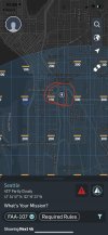
I think looking at the AirMap from @brett8883 it doesn’t look like restricted airspace. I think KittyHawk would provide more accurate information. Beautiful Picture!
 
UCSF is like many entities that try and control more than they're allowed. If I was local, I'd address this with them.

They have zero authority to control any airspace by those not associated with the university. They are allowed to have height restrictions and other restrictions attached to any permit they issue for drone use on their property.
 
  • Like
Reactions: Corsair415
I don't see any blatant violation. Doesn't even look like you, ummm your friend is above 400" agl. Nice shot.
 
I don't think so because it couldn't very well be proven that it was taken from a drone.

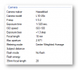
The camera info in the picture guarantees it was taken from an M2P. Though I wouldn't be too worried about the FAA chasing me down, it might be a good idea to scrub the EXIF data from a picture before you post it on the webz.

1605273848089.png
 
  • Like
Reactions: DoomMeister
There are no restrictions related to helipads.

yes and no? I live near Mayo Clinic in Phoenix. the airspace block surrounding them is explicitly 0ft clearance available. (They have a fairly active helipad.)

On the flip side it is also within the cotrolled airspace zone around SDL (scottsdale airport.) Wether not not Mayo would have any restriction, if not already conveniently located inside an airport zone, i don't know, but they most definitely have restrictions specific to that hospital helipad.
 
i'm a few GPS seconds away and bike past that spot weekly. The presumed launch site
is extemely popular and you see small gaggle of photographers there at dusk. I should
launch and take a pano from the location sometime. It's quite photogenic vantage spot
(snow capped mountains, city scape, Needle, pro sports stadiums, ribbon of interstate.....)

1605374335073.png
 
Can't help you with the laws, but that sure is a beautiful picture!

Yes, the ferry is a memory of nearly identical ones we had once between Jamestown, RI, and Newport, RI. Beautiful.
 
yes and no? I live near Mayo Clinic in Phoenix. the airspace block surrounding them is explicitly 0ft clearance available. (They have a fairly active helipad.)

On the flip side it is also within the cotrolled airspace zone around SDL (scottsdale airport.) Wether not not Mayo would have any restriction, if not already conveniently located inside an airport zone, i don't know, but they most definitely have restrictions specific to that hospital helipad.
Right you have a helipad inside of controlled airspace which is controlled by the tower at SDL. The helipad doesn’t have a control tower.
 
  • Like
Reactions: nhgill960
As far as I know airspace above property in most cases isn’t legal, but I’m extremely new to this hobby and don’t know if there’s an exception in this case due to it being a hospital helipad. I’m hoping that someone more knowledgeable would chime in.
Property owners do not own the airspace above their property. That's the domain of the FAA. Unless it's restricted airspace you are perfectly within your rights to fly over people's houses, yards, etc (but not people). Also, FAA rules state that you can fly no closer than 400ft horizontally to a building and no more than 400feet above. So the "400ft" ceiling actually goes up with the height of the structure you are flying over. So a 300foot tall building means you can fly 700ft or whatever the defined ceiling height for that airspace is...if it says 300ft then you can go 600, but if it's 250, then you are SOL as you can't even get to the top of the building. :). At least that's my understanding from all the info I've been studying for my part 107.
 
Seattle airspace is very complicated. Based on the photo here, it looks like the legal limit would have been 100 AGL.

It's hard to fly legally in Seattle, starting with the Seattle Municipal Code, which prohibits the launch of drones from all public property without a city film office permit. (Because, you know, why would you need to fly a drone except to film a movie or TV commercial?)

Also, the University of Washington prohibits drone launches from its property.

These rule are often ignored, of course.

Then there's the airspace itself. Outside the BFI, SEA and RNT airspaces, which are B and D and overlap, the biggest problem with flying in Seattle is all the floatplane and helicopter traffic. Every hospital has a pad. I-5 is a designated VFR helicopter route. It's a good idea to monitor 122.9 for civilian aircraft. But other aircraft, including AirLift Northwest medical choppers, are not checking in with multicom, and you need to literally keep an ear out for them.

As for the Class B/D space having irregular altitude limits, that likely has to do with hills and the sheer volume of traffic in and out of BFI, which is at sea level. There is a hill just east of BFI that's 350 MSL, which means a drone flying there at even 200 AGL could get uncomfortably close to pattern altitude for runway 14L/32R. The limit there is zero.
 
Property owners do not own the airspace above their property. That's the domain of the FAA. Unless it's restricted airspace you are perfectly within your rights to fly over people's houses, yards, etc (but not people). Also, FAA rules state that you can fly no closer than 400ft horizontally to a building and no more than 400feet above. So the "400ft" ceiling actually goes up with the height of the structure you are flying over. So a 300foot tall building means you can fly 700ft or whatever the defined ceiling height for that airspace is...if it says 300ft then you can go 600, but if it's 250, then you are SOL as you can't even get to the top of the building. :). At least that's my understanding from all the info I've been studying for my part 107.

This is a bit confusing.

There is no FAA rule that says you can fly no closer than 400' to a building. I'm not sure what you got that from.

As far as the 400' and above, that is only good for uncontrolled airspace. The maximum AGLs listed in a UASFM (gird map) is the highest you can go without authorization to go higher. Maybe that's what you meant, but it's a bit confusing how you wrote it.
 
  • Like
Reactions: brett8883
Lycus Tech Mavic Air 3 Case

DJI Drone Deals

New Threads

Members online

Forum statistics

Threads
130,978
Messages
1,558,524
Members
159,966
Latest member
rapidair