DJI Mavic, Air and Mini Drones
Friendly, Helpful & Knowledgeable Community
Join Us Now

Posting images with potential height violations

Not A Speck Of Cereal

Well-Known Member
Joined
Apr 26, 2019
Messages
1,434
Reactions
1,186
Hey there,

Please see the attached image below, taken by <ahem> a friend.

Only after the flight was over and the images were being reviewed was it clear that the Mavic was somewhat near the hospital with the heliport. See to the right of the freeway image lower-center, a flat area with 3 circles on it. There was NO other air traffic at the time, but still, it looks close.

The area was reported as "height restricted" in DJI Go 4 due to local air-space classifications and the aircraft stayed below that height, but it was thought that the restriction was for an airport (Boeing Field Int.) that was a few miles behind the image. And maybe it was.

My question is: could someone get in trouble posting this image to social media? Would some authority look at that and say "Okay, that's a baddie" and report the poster to the FAA or something?

Or is it simply a case of, if the operator is observing restrictions as reported by the controller app, they are okay?

Thanks for any input,
Chris
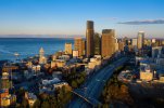
Jose Rizal_11-7-20_A07_DJI_0933 HELO.jpg
 
Last edited:
Hey there,

Please see the attached image below, taken by <ahem> a friend.

Only after the flight was over and the images were being reviewed was it clear that the Mavic was somewhat near the hospital with the heliport. See to the right of the freeway image lower-center, a flat area with 3 circles on it. There was NO other air traffic at the time, but still, it looks close.

The area was reported as "height restricted" in DJI Go 4 due to local air-space classifications and the aircraft stayed below that height, but it was thought that the restriction was for an airport (Boeing Field Int.) that was a few miles behind the image. And maybe it was.

My question is: could someone get in trouble posting this image to social media? What some authority look at that and say "Okay, that's a baddie" and report the poster to the FAA or something?

Or is it simply a case of, if the operator is observing restrictions as reported by the controller app, they are okay?

Thanks for any input,
Chris

View attachment 117032
I am not even clear that there is anything wrong with the flight in the first place. There are no restrictions related to helipads.

Depending on where this is it may be far enough away from the airport that it’s not in controlled airspace at all.

Even if it is in controlled airspace you can easily get authorization to fly there which I wouldn’t know if you got or not.

The FAA investigated when a complaint is made. They don’t go looking through the internet to find violations
Thanks Brett, that makes sense.

As for the FAA not looking for violators, I'm convinced that are plenty of citizen police that are happy to report. I mean, I would too for gross violations (like the idiot flying over a crowded July 4th celebration).

But I've been approached by people that want to inform me that I'm doin' wrong and when I tell them that I am observing the airspaces reported by the controller and my knowledge of local airspace, they continue to press on. At that point, I point out to them that their continued discussion with me is diverting my attention from flying, which is a hazard to my flight.

However, that's the kind of guy that might object to the above image being on social media.

Some cities, like Seattle, have a lot of air harbors. They cannot restrict all of the airspace they fly in., so I follow the "give way to manned aircraft" rule. And frankly, you just got'a keep your ears open in a place like this.

Chris
 
I am not even clear that there is anything wrong with the flight in the first place. There are no restrictions related to helipads.
I was doing some research regarding flying on UCSF property, and they claim to be able to restrict flight well outside their property:

Proposed UAS/drone operations outside of the 1-mile radius are allowed – as directed by FAA governance -as long as the drone operator is cognizant and avoids helicopter flight.
Within the 1-mile radius UAS/drone operations must be under 156 feet mean sea level (MSL) in relation to topography (140 feet AGL at actual helideck height).
Operations/flights above 140 AGL at Helideck/156 MSL within the 1-mile radius is unacceptable due to the safety risks placed on helicopter flight.


Depending on where this is it may be far enough away from the airport that it’s not in controlled airspace at all.

I forgot to mention: There was controlled airspace closer to the controller, because the operator was nearer to the BFI airport. But the height got lower as one gets closer to the airport (like an bowl). So flying back, one had to reduce altitude just to get back over home point (where the ceiling was much lower).

A person flying one of these M2P's cannot violate that airspace. It just stops at the boundary up in the sky, like it encountered a glass wall.

Chris
 
  • Like
Reactions: Romulus Archibald
I was doing some research regarding flying on UCSF property, and they claim to be able to restrict flight well outside their property:
Are they actually able to do that??? What, is it restricted because flying within their zone might cause cancer???? I do not know California law, but restricting flight that is not directly over their property seems like a stretch. Here in Illinois, launching and landing from certain properties can be restricted, but flying in the the airspace above cannot be restricted "just because".
 
  • Like
Reactions: darrellcowles1
Are they actually able to do that??? What, is it restricted because flying within their zone might cause cancer???? I do not know California law, but restricting flight that is not directly over their property seems like a stretch. Here in Illinois, launching and landing from certain properties can be restricted, but flying in the the airspace above cannot be restricted "just because".
As far as I know airspace above property in most cases isn’t legal, but I’m extremely new to this hobby and don’t know if there’s an exception in this case due to it being a hospital helipad. I’m hoping that someone more knowledgeable would chime in.
 
I forgot to mention: There was controlled airspace closer to the controller, because the operator was nearer to the BFI airport. But the height got lower as one gets closer to the airport (like an bowl). So flying back, one had to reduce altitude just to get back over home point (where the ceiling was much lower).

A person flying one of these M2P's cannot violate that airspace. It just stops at the boundary up in the sky, like it encountered a glass wall.

Chris
I think we need to have a discussion about DJI’s GeoZones.

The GeoZones in the DJI app do not follow actual controlled airspace ever. Using the DJI app to determine where controlled airspace starts and ends will result in failure 100% of the time. Sometimes the app is more strict then the actual airspace and sometimes it’s less strict but it is wrong 100% of the time.

Regardless if this flight was legal or not your friend should really use something like AirMap or KittyHawk before a flight to know for sure
I was doing some research regarding flying on UCSF property, and they claim to be able to restrict flight well outside their property:

Proposed UAS/drone operations outside of the 1-mile radius are allowed – as directed by FAA governance -as long as the drone operator is cognizant and avoids helicopter flight.
Within the 1-mile radius UAS/drone operations must be under 156 feet mean sea level (MSL) in relation to topography (140 feet AGL at actual helideck height).
Operations/flights above 140 AGL at Helideck/156 MSL within the 1-mile radius is unacceptable due to the safety risks placed on helicopter flight.


This is for flying a drone for “university business” under public flight rules. Law enforcement, universities, the government etc. don’t follow the same rules as the public.

They can tell you not to take off from their property but they can’t tell you not to fly over. Theres no special rules under part 107 or the exception for recreational use that mentions anything about helipads and no helipad has its own control tower.
 
Are they actually able to do that??? What, is it restricted because flying within their zone might cause cancer???? I do not know California law, but restricting flight that is not directly over their property seems like a stretch. Here in Illinois, launching and landing from certain properties can be restricted, but flying in the the airspace above cannot be restricted "just because".
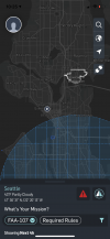
I assume your friend was flying somewhere in this area 7D8DC2A6-40A6-49CC-9829-5F762EB42A31.png
If he was in the blue area he should have gotten authorization which is really easy and automatic and then he wouldn’t have had to worry about anything. At any rate as long as he doesn’t tell anyone he didn’t have authorization there’s no reason for anyone to question if he did or not. I think posting the photo is fine.
 
As far as I know airspace above property in most cases isn’t legal, but I’m extremely new to this hobby and don’t know if there’s an exception in this case due to it being a hospital helipad. I’m hoping that someone more knowledgeable would chime in.
It’s the opposite. You don’t own the airspace above you so it’s legal to fly there as long as there aren’t restrictions put in by the FAA. It’s just like the airlines don’t have to call you ask your permission to fly over your property. Same concept applies.
 
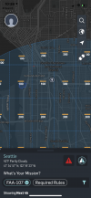
Oops I figured out where this was and it is in controlled airspace.

9E8A3BAD-0987-4D7F-9E7F-6437DA9FA5EF.png
It’s a curiously low ceiling for being that far from the airport. I don’t think I’ve ever seen that before.

FWIW now that I know where this is it would be very easy to prove that your friend was breaking the rules because there’s no legal way a recreational pilot could be that high in that area. If you are worried about it and it sounds like you are then maybe I wouldn’t post it.
 
You must have got the coords from the image, because that looks accurate. HP was I think in the 100 area, but I believe the photo was taken in the 200 area. Still, it was probably too high. Thanks for checking it.
 
This is for flying a drone for “university business” under public flight rules. Law enforcement, universities, the government etc. don’t follow the same rules as the public.

They can tell you not to take off from their property but they can’t tell you not to fly over. Theres no special rules under part 107 or the exception for recreational use that mentions anything about helipads and no helipad has its own control tower.
Thank you for the input.
It’s the opposite. You don’t own the airspace above you so it’s legal to fly there as long as there aren’t restrictions put in by the FAA. It’s just like the airlines don’t have to call you ask your permission to fly over your property. Same concept applies.
Sorry, I meant to write that it was legal to fly above others property. Don’t know what I was thinking with that wording.
 
  • Like
Reactions: brett8883
My question is: could someone get in trouble posting this image to social media? Would some authority look at that and say "Okay, that's a baddie" and report the poster to the FAA or something?
Here is the guidance from the FAA to their inspectors on the process of contact and education generally to be provided to individuals who are the subject of an inquiry relating to an unauthorized or unsafe operation of Unmanned Aircraft Systems (UAS) in the National Airspace System (NAS)


DJI Drone Deals

New Threads

Forum statistics

Threads
130,593
Messages
1,554,206
Members
159,598
Latest member
fast54