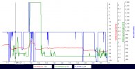
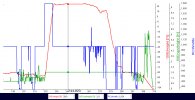
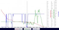
Where the Green VPS height line reappears at about 118secs, the drone is now low enough for the VPS sensor to detect stuff underneath it.
With no throttle input (Blue line level at mid-point), I'd expect the Red barometric altitude line to remain level, while the Green VPS height line fluctuates as the drone passes over varying terrain height, or as the waves roll past underneath. (We don't know if it's the water level of the wave top itself, or of the significant spray above the wave top.)
Does the Mavic2Pro have the same 0.5m (2ft) Landing Protection feature as my Mini? Note the very first couple of blips in the Green VPS height line between 118-121 secs. The VPS height fluctuates between 0.9ft, up to 2.6ft, down to 1.6ft, back up to 2.6ft, then down to only 0.6ft at the 121 sec mark shown. If my Mini detected a VPS height of less than 2ft, Landing Protection would automatically kick in to raise the drone up.
Note the Blue throttle line stays flat without moving during that period, but the red Barometric height goes up 4ft all by itself from -77.3ft at the start of the Green line up to -73.4ft after those first few squiggles. Then the Green VPS line goes suspiciously flat showing a constant 1.3ft height even thought the throttle is dipped down for a moment.
A couple more tiny squiggles in the green line, then it goes completely flat showing 0.9ft, even though the throttle (Blue line) is abruptly raised for a moment at 135sec. The Red barometric line shows a corresponding 20ft increase in height from -77ft up to -57ft. whereas the Green VPS line suddenly spikes straight up to a flat 9.5ft and sticks there. I suspect here the VPS infrared height sensor already either got splashed by a wave or at least thoroughly misted by the spray, prompted the sudden full up throttle input from the pilot.
Then there are a couple of full down throttle applications to lower the drone right back down 20ft to its previous -77ft nearer the water's surface, while the VPS height remains stuck showing 9.5ft until it suddenly starts working again at 147secs. But it's still not working correctly. The VPS height sensor then, except for a couple of brief moments, sticks at 0.9ft all the way across to the right until about 203secs, where it suddenly comes alive again.

More to follow...
With no throttle input (Blue line level at mid-point), I'd expect the Red barometric altitude line to remain level, while the Green VPS height line fluctuates as the drone passes over varying terrain height, or as the waves roll past underneath. (We don't know if it's the water level of the wave top itself, or of the significant spray above the wave top.)
Does the Mavic2Pro have the same 0.5m (2ft) Landing Protection feature as my Mini? Note the very first couple of blips in the Green VPS height line between 118-121 secs. The VPS height fluctuates between 0.9ft, up to 2.6ft, down to 1.6ft, back up to 2.6ft, then down to only 0.6ft at the 121 sec mark shown. If my Mini detected a VPS height of less than 2ft, Landing Protection would automatically kick in to raise the drone up.
Note the Blue throttle line stays flat without moving during that period, but the red Barometric height goes up 4ft all by itself from -77.3ft at the start of the Green line up to -73.4ft after those first few squiggles. Then the Green VPS line goes suspiciously flat showing a constant 1.3ft height even thought the throttle is dipped down for a moment.
A couple more tiny squiggles in the green line, then it goes completely flat showing 0.9ft, even though the throttle (Blue line) is abruptly raised for a moment at 135sec. The Red barometric line shows a corresponding 20ft increase in height from -77ft up to -57ft. whereas the Green VPS line suddenly spikes straight up to a flat 9.5ft and sticks there. I suspect here the VPS infrared height sensor already either got splashed by a wave or at least thoroughly misted by the spray, prompted the sudden full up throttle input from the pilot.
Then there are a couple of full down throttle applications to lower the drone right back down 20ft to its previous -77ft nearer the water's surface, while the VPS height remains stuck showing 9.5ft until it suddenly starts working again at 147secs. But it's still not working correctly. The VPS height sensor then, except for a couple of brief moments, sticks at 0.9ft all the way across to the right until about 203secs, where it suddenly comes alive again.

More to follow...


