DJI Mavic, Air and Mini Drones
Friendly, Helpful & Knowledgeable Community
Join Us Now

RTH - gps fault

dopey dingo

Member
Joined
Apr 5, 2021
Messages
13
Reactions
6
Age
23
Location
Australia
G'Day
I am still very much a newcomer to this drone experience but after a few months I have a few questions.
I regularly need to re calibrate the navigation on my Pro 2, I expects thats normal but often (not always) when using RTH the drone land up to 4M away from the take off point.
It wouldn't be a problem except often I fly in forests and only have a 3-4m opening in which to get above the trees. Fortunately I have set the rth height to 60m so it covers the tree tops before descending but if I am not watching and manually positioning it before it comes down there could be a disaster.
Do I need to set/reset the gps somehow?
The second question is; I hear all sorts of things about VLOS and people flying miles away but I struggle to see the drone more than 200-300 meters away, particularly if I look down at the controller and look back up it just disappears :)
Has anybody tried painting their drone with something like fluoro colours, maybe (hot pink) so it is more visible?
Thanks
DD
 
DD, what you describe there is so fraught with danger . . . well, you're obviously aware of that.
Sounds like you're in the tropics, and flying rainforest type terrain / canopy ?

The biggest issues.

Signal controller to drone will be easily compromised, meaning RTH has a lot more potential to kick in.
This is due to the canopy / foliage interference.
You can only avoid this by staying reasonably close, and as overhead as possible.

VLOS is a byproduct of the foliage issue, and also adds an element of danger not really being able to see it approaching / descending etc.
A strobe like an ARCII or ARCXL might help, the ARCXL in particular to aid recovery if it goes down (audible alarm).
A skin with underside bright orange might help too, even some suitable fluro orange type signwriting vinyl cut to suit.

If you are getting good GPS at launch (Home point recorded, and ensure precision landing is activated as per manual for the M2), then it should function RTH pretty well, and looking up you can see it and make some minor adjustments as needed.
If not getting good GPS lock at take off, this really makes it risky.

If flying below the canopy, I would have said have failsafe RTH set to hover, and move to the drone to re-establish signal.
Above the canopy, you could try the same thing, but obviously the terrain and vegetation might make that difficult, if not impossible.

I'm not sure there is a way to totally avoid the risks you are facing, apart from looking for the clearings at roadside to launch from, or if bushwalking, find the clear areas to get away and back safer.
 
Thank you so much for the reply and your thoughts.

DD, what you describe there is so fraught with danger . . . well, you're obviously aware of that.
Sounds like you're in the tropics, and flying rainforest type terrain / canopy ?
No, in WA but often need to launch from the bush to access rivers and dams where the bush grows to the waters edge
The biggest issues.

Signal controller to drone will be easily compromised, meaning RTH has a lot more potential to kick in.
This is due to the canopy / foliage interference.
You can only avoid this by staying reasonably close, and as overhead as possible.

VLOS is a byproduct of the foliage issue, and also adds an element of danger not really being able to see it approaching / descending etc.
A strobe like an ARCII or ARCXL might help, the ARCXL in particular to aid recovery if it goes down (audible alarm).
A skin with underside bright orange might help too, even some suitable fluro orange type signwriting vinyl cut to suit.
Some good ideas, thank you, I take it you're not a fan of Hot Pink
If you are getting good GPS at launch (Home point recorded, and ensure precision landing is activated as per manual for the M2), then it should function RTH pretty well, and looking up you can see it and make some minor adjustments as needed.
If not getting good GPS lock at take off, this really makes it risky.
I get excellent gps at take off but its the landing that I have problems with - maybe I will study the manual some more in case I am missing something
If flying below the canopy, I would have said have failsafe RTH set to hover, and move to the drone to re-establish signal.
Above the canopy, you could try the same thing, but obviously the terrain and vegetation might make that difficult, if not impossible.

I'm not sure there is a way to totally avoid the risks you are facing, apart from looking for the clearings at roadside to launch from, or if bushwalking, find the clear areas to get away and back safer.
Thanks again
 
I regularly need to re calibrate the navigation on my Pro 2, I expects thats normal but often (not always) when using RTH the drone land up to 4M away from the take off point.
What are you recalibrating?
There is nothing you can recalibrate that will make any difference to where your drone will autoland on RTH.
You don't mention which drone you have but many DJI models have two separate systems that can position the autoland after RTH.
One is GPS and consumer GPS is not pinpoint accurate as you might imagine.
It's normal for consumer GPS to have an error of +/- 2 metres or sometimes more.
You might be losing GPS and accuracy further when teh drone descends under tree cover.
If your drone has the Precision Landing feature, that can position the drone within a few inches, as long as certain conditions are met.

Perhaps you don't realise that there's no need to rely on autolanding and RTH to bring your drone back at all.
You can fly it back yourself and you can always cancel RTH or autolanding and resume control to land the drone wherever you choose, rather than depending on dumb technology.

It wouldn't be a problem except often I fly in forests and only have a 3-4m opening in which to get above the trees. Fortunately I have set the rth height to 60m so it covers the tree tops before descending but if I am not watching and manually positioning it before it comes down there could be a disaster.
If you choose to fly in that environment, you need to understand the risks and the limitations of the technology you are using.
With experience, it's possible to fly in that environment, but it has significant risks.

Finding a safer place for launching/landing would be a good way to reduce the risks.
Do I need to set/reset the gps somehow?
There is no way to do that and as explained above, it won't make any difference.
Has anybody tried painting their drone with something like fluoro colours, maybe (hot pink) so it is more visible?
A brightly coloured drone might be more visible when relatively close, but if the drone is far away,. it's just a dot and the colour makes no difference.
 
No, in WA but often need to launch from the bush to access rivers and dams where the bush grows to the waters edge

Some good ideas, thank you, I take it you're not a fan of Hot Pink

I get excellent gps at take off but its the landing that I have problems with - maybe I will study the manual some more in case I am missing something

Thanks again

Ah, maybe better to launch from back away from the treeline then, obviously it's less dense back aways ?

Colour doesn't bother me, have fluro pink safety tape on my gimbal clamp :)
Just thought fluro orange would stand out (ok, and not be so embarrassing if others are around :p )

Maybe precision landing isn't getting a chance to do its thing ?
Just had a search, with the M2, the manual page 19 . . .

https://dl.djicdn.com/downloads/Mavic_2/Mavic 2 Pro Zoom User Manual V1.6.pdf

Most important things . . .
Must rise vertically 7m on take off without horizontal movement, you should get a notification it's activated.
Have good light.
Good ground feature(s), a landing pad H is excellent.
A few other things mentioned on that page.
 
  • Like
Reactions: DoomMeister
It wouldn't be a problem except often I fly in forests and only have a 3-4m opening in which to get above the trees. Fortunately I have set the rth height to 60m so it covers the tree tops before descending but if I am not watching and manually positioning it before it comes down there could be a disaster.
Do I need to set/reset the gps somehow?
I can add one specific comment to some of the other good suggestions.
I always rise ~25 feet or so vertically to ensure good GPS reception (although you may need to go higher in your environment) before I move horizontally...and I typically get RTH landings within inches of the target.
Having said that, launching from a more GPS friendly location (beyond tree cover) may be advantageous if for no other reason than the interference you will experience between RC/AC from foliage.
 
  • Like
Reactions: umanbean
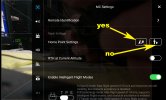
is your home point settings set to current position as the home point and not the controller as the rth point?
Everyone's homepoint is automatically set as the drone's startup location.
The settings you have pointed out are an option for resetting the homepoint during the flight.
 
correct. I was pointing out that it might have been changed for some reason, and the 4M error could easily be where he was standing with the controller.
 
correct. I was pointing out that it might have been changed for some reason, and the 4M error could easily be where he was standing with the controller.
Anyone that resets their homepoint during a flight (and almost no-one does) would be aware of that.

Four metres is within the accuracy of consumer GPS.
It's also quite likely that his drone is losing GPS when coming down under tree canopy.
It that case, the error could be even more.
 
I always give a 20 sec. hover over my launch pad to aid the precision landing, that plus the gps usually brings my m2pro back within inches. Not quite as accurate on my mini 2 but still not meters.
 
I think with my short time flying, strobes are better for visibility, and skins are just for looks. I have a bright orange skin, and can see the color for about 100 feet/30 meters there about, after that approximate distance you can't tell what color it is. The bright skin would aid in retrieval of your drone should it end up in the brush, but you will have to be near if you brush is like mine.
 
can see the color for about 100 feet/30 meters there about, after that approximate distance you can't tell what color it is.

Funny it's similar for strobes.
Beyond a certain point, you can't pick red / green on relative body sides, they appear as one once they 'merge' at distance, and they are far less visible than the white strobes.
If buying for VLOS use (to a reasonable distance), then white is the go to for that.

I use FHT Dual and ARCII strobes, getting from the US to here is pretty hard, had to get shipped to a niece in the US, then onforwarded.

DD, if you want something to try, and these are very good, easy to find a spot on your M2, I have some extras of these FHT 'Spark' strobes . . . the FHT website no longer has them, looks like they've moved on to the ARC5 etc.

This page shows it, also says it is now obsolete . . .


Here is one on my BILs Air . . .


The acrylic dome throws light out to perhaps 160 degrees clearly, mounting underneath is the best spot, especially for your flights.

Drop me a PM / Conversation if interested DD.
 
I always give a 20 sec. hover over my launch pad to aid the precision landing, that plus the gps usually brings my m2pro back within inches. Not quite as accurate on my mini 2 but still not meters.
Could the better accuracy without Precision Landing on the Mini 2 be down to the Mini 2 being compatible with the Galileo satellite navigation system? As I understand it, it’s more accurate than Glonass and GPS.
 
Could the better accuracy without Precision Landing on the Mini 2 be down to the Mini 2 being compatible with the Galileo satellite navigation system? As I understand it, it’s more accurate than Glonass and GPS.
He mentioned it being within inches, so that's optical technology of the Precision Landing feature.
GPS won't get that kind of repeatable accuracy, with or without Gallileo.
 
Lycus Tech Mavic Air 3 Case

DJI Drone Deals

New Threads

Members online

Forum statistics

Threads
131,232
Messages
1,561,069
Members
160,184
Latest member
peehead