DJI Mavic, Air and Mini Drones
Friendly, Helpful & Knowledgeable Community
Join Us Now

SAR Advice

ottodawg

Well-Known Member
Joined
Dec 28, 2018
Messages
95
Reactions
63
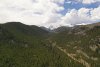
Barring a SAR course, are there any recommended methods for searching by air. Case, we live in the national forest and had some campers lose a dog after being hit by a car. Now I make no claims of being an expert in anything search or rescue wise, I decided to send the bird out over the area for a few hours to see if I could help them out.
My question, are there certain patterns/altitudes etc. that work better than others? I started lower, maybe 20' off the treetops in a sort of grid pattern, decided that wasn't great, so went to a higher altitude scan looking for movement. I guess the problem is more of looking for something that doesn't want to be seen and blending perfectly with the environment. After a few hours of flight, I pretty much got the "needle in a haystack" feeling.

Does anyone have any experience/advice with this? Yes, FLIR would be the obvious choice. :p
 
Check out DSAR and we do have training events.

I've got several Real-World Drone SAR (for people and for a few animals) under my belt and I can tell you it's a lot harder than it would seem. The more "natural" the color and the more skittish the animal the tougher the search is. It's even hard to find people who are lost and WANT to be found. So many variables (angle of viewing, thickness of the canopy, thickness of lower vegetation, time of day, height, viewing angle ....) and if you happen to blink at the wrong time you may miss a clue.

FLIR/Thermal is a great advance in searching but it's still not perfect and has a LOT of limitations.

Ask any questions you may have and we'll try to answer them.
 
  • Like
Reactions: Smalls
Check out DSAR and we do have training events.

I've got several Real-World Drone SAR (for people and for a few animals) under my belt and I can tell you it's a lot harder than it would seem. The more "natural" the color and the more skittish the animal the tougher the search is. It's even hard to find people who are lost and WANT to be found. So many variables (angle of viewing, thickness of the canopy, thickness of lower vegetation, time of day, height, viewing angle ....) and if you happen to blink at the wrong time you may miss a clue.

FLIR/Thermal is a great advance in searching but it's still not perfect and has a LOT of limitations.

Ask any questions you may have and we'll try to answer them.

Thanks BigAl07, yeah he's brindle (perfect camo) and injured and terrified I'm sure. Colorado forest isn't quite as dense as the east, but still fairly heavy. I tried early this morning but soon figured out the high sun angle wasn't helpful. I guess the midday overhead sun would be the best. We're getting into days now so I guess a dog could be a long way away. The owners did find some blood trail further up the mountain, so i concentrated up there.
 
  • Like
Reactions: Smalls and BigAl07
Where in Colorado are you?
 
  • Like
Reactions: BigAl07
This is the type of terrain we're talking about. He ran up to the right of the road.
 

Attachments

  • DJI_0126.JPG
    DJI_0126.JPG
    8.4 MB · Views: 36
Unfortunately in that type of terrain and with that lead time following the trail by ground and attempting to get the dog to respond to calls will be your best bet. Like Allen said in conditions like that it is hard to find a person from the air let alone a animal.
 
  • Like
Reactions: ottodawg
Unfortunately in that type of terrain and with that lead time following the trail by ground and attempting to get the dog to respond to calls will be your best bet. Like Allen said in conditions like that it is hard to find a person from the air let alone a animal.
Thanks and understand.
 
Check out DSAR and we do have training events.

I've got several Real-World Drone SAR (for people and for a few animals) under my belt and I can tell you it's a lot harder than it would seem. The more "natural" the color and the more skittish the animal the tougher the search is. It's even hard to find people who are lost and WANT to be found. So many variables (angle of viewing, thickness of the canopy, thickness of lower vegetation, time of day, height, viewing angle ....) and if you happen to blink at the wrong time you may miss a clue.

FLIR/Thermal is a great advance in searching but it's still not perfect and has a LOT of limitations.

Ask any questions you may have and we'll try to answer them.
Can you see if I was added to the registry? I sent the info a week or two ago and never heard a word. Thanks!
 
FYI. It is unlawfull to Launch, Land, or Operate from a National Park. So if you are doing so, and since you are trying to support a SAR function, you should check with the Park Superintendent prior to get approval.

Policy Memorandum 14-05, released by the National Park Service (NPS) director in June 2014, directed each superintendent to use the authority under 36 CFR 1.5 to prohibit the launching, landing, or operation of unmanned aircraft, subject to the certain conditions and exceptions set forth in the memo. This is still in force with very few exceptions.
 
Can you see if I was added to the registry? I sent the info a week or two ago and never heard a word. Thanks!

Greg - I went back through the contact info and didn't see you. I may have mistakenly deleted it as there was a lot of contact stuff to plow through and clean up. Please PM me your contact info and I'll ensure you're added. Sorry.

Name
Email
Phone
Location
 
FYI. It is unlawfull to Launch, Land, or Operate from a National Park. So if you are doing so, and since you are trying to support a SAR function, you should check with the Park Manager prior to get approval.

Policy Memorandum 14-05, released by the National Park Service (NPS) director in June 2014, directed each superintendent to use the authority under 36 CFR 1.5 to prohibit the launching, landing, or operation of unmanned aircraft, subject to the certain conditions and exceptions set forth in the memo. This is still in force with very few exceptions.


You are correct and in a live SAR Mission they not only give permission they actually assign a representative to our team but they will ONLY give permission when it's part of an "Official" (as in coordinated with Incident Command) search.
 
FYI. It is unlawfull to Launch, Land, or Operate from a National Park. So if you are doing so, and since you are trying to support a SAR function, you should check with the Park Superintendent prior to get approval.

Policy Memorandum 14-05, released by the National Park Service (NPS) director in June 2014, directed each superintendent to use the authority under 36 CFR 1.5 to prohibit the launching, landing, or operation of unmanned aircraft, subject to the certain conditions and exceptions set forth in the memo. This is still in force with very few exceptions.

Not applicable to the OP's operation in a National Forest which is pro drone.

 
Lycus Tech Mavic Air 3 Case

DJI Drone Deals

New Threads

Forum statistics

Threads
131,296
Messages
1,561,790
Members
160,242
Latest member
dominicus15