DJI Mavic, Air and Mini Drones
Friendly, Helpful & Knowledgeable Community
Join Us Now

Screen recording format / altitude readout

Hfcomms

Member
Joined
Feb 7, 2023
Messages
14
Reactions
45
Age
62
Location
Marquette, MI, USA
Hi;

Only have had the mini 3 pro and controller for a few days and have two questions that I can’t answer yet after searching.

1) I have apple products and like to record in .mov format. I put the drone camera into .mov and it records as it should. That doesn’t appear to affect the RC controller video format though as those videos are all recording in .mp4. Question, is there any way to enable screen recordings in .mp4 format?

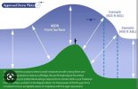
2) When homepoint is set and lets say you takeoff and ascend to the legal altitude of 400 AGL above your homepoint and you fly 2km away into ascending terrain. At the 2km point the elevation is 100ft greater than your homepoint. Assuming you don’t climb from the homepoint when you get 2km away is your altitude still going to be 400 ft or thru the satellites is your reading now going to be 300 ft accurately registering the drone’s elevation above ground at it’s destination?

Thanks for the input and still have much to learn here.
 
I can't answer the first one, but this graphic may shed some light on the 400 AGL rule.

Screenshot_20230215_113535_Chrome.jpg
 
  • Like
Reactions: Richard R
Thanks!

I was assuming that to stay within the regs that its 400 feet above terrain from the drone’s perspective where it is currently at. So if you fly into ascending terrain you can climb above your 400' homepoint but should descend on the way back.

I live in a rather unpopulated area so if I occasionally break the 400' rule it's not going to cause any angst but it was a bit fuzzy to me if the altitude readout on the controller reflected the altitude of the drone above the homepoint or the actual altitude of the drone regardless of the terrain its currently flying over.
 
if the altitude readout on the controller reflected the altitude of the drone above the homepoint or the actual altitude of the drone regardless of the terrain its currently flying over.
It shows the altitude above the take-off point, during the whole flight.
 
O.K.

That is a point that should probably be made clear in the manual unless I missed it. I was thinking that since the GPS receiver is in the drone and not the remote control that as the drone moves it would calculate the drone's current height above the ground which of course would fluctuate as the terrain level goes up or down versus the home point.

If you are flying at 400' above your home point and you know that where you are flying to is 100' above your homepoint then you could legally climb to 500' at your destination and still only be 400' above ground level and then as you fly back to the homepoint you would have to descend accordingly.

I just wanted to be clear in my own mind how the altitude readout was figured.

Thanks!!
 
I was thinking that since the GPS receiver is in the drone and not the remote control that as the drone moves it would calculate the drone's current height
The drone does not use GPS to determine height, it uses a barometer, just like all airplanes. Actually GPS and other navigational satellites are not very good at calculating height.

If you are flying at 400' above your home point and you know that where you are flying to is 100' above your homepoint then you could legally climb to 500' at your destination and still only be 400' above ground level and then as you fly back to the homepoint you would have to descend accordingly.
Yes, that is correct.
 
So if you fly into ascending terrain you can climb above your 400' homepoint but should descend on the way back.


Yes. That is correct.

While I was flying from a lake in the valley up over a hill to see the other side, I'd stay within 400 feet of the terrain while traversing up.

You might have to reset the altitude height in the app to a higher value to safely traverse the hill within 400 feet of the terrain, but you actually might be 1000 feet or more above the launch point.

As long as you are within 400 feet of the ground, you're good to go.

Don't launch straight up to a thousand feet and then go over the hill, follow the terrain.

.
 
it was a bit fuzzy to me if the altitude readout on the controller reflected the altitude of the drone above the homepoint


Launch from a hill and fly down in the valley as an experiment.

You might see negative numbers in the altitude since the drone is lower than the launch point.

VLOS is best when flying these rascals.

.
 

DJI Drone Deals

New Threads

Forum statistics

Threads
134,485
Messages
1,595,523
Members
163,013
Latest member
GLobus55
Want to Remove this Ad? Simply login or create a free account