Just mucking around down at a local shipwreck, the lighting was perfect just before sunset
 Sunset Pano by Ian Lucas, on Flickr
Sunset Pano by Ian Lucas, on Flickr Sunset Pano by Ian Lucas, on Flickr
How did they get that ship all the way in there?
I've always wondered the same thing.How did they get that ship all the way in there?
Thanks mate, it's a great little spot, especially at night for long exposures and light painting, although the mozzies are fierce!Towed it up the small inlet and abandoned.
It’s Excelsior, an old steamer, parked up in Mutton Cove sanctuary after it’s working life came to an end.
At one point after abandonment, it was used as a live seafood ‘tank’ by fishermen.
Nice video and photo Ian, flew that and the main ships graveyard at Garden Island Oct 2019, long overdue for another day trip down the port area.
although the mozzies are fierce!
That's interesting. I'd assume the power station just has high interference due to the power it's producing, however I'm not sure that has powered rig runs all that often, only in peak loading in summer.Oh yeah, I bet they are !!
End of that road In is a great place to film ships coming and going.
There is some sort of drone blocking tech in Pelican Point power station just downriver though, had to do a detour along the river back once as I couldn’t get it to move over the edge of the land area past the riverbank (for more drone safety).
Also has a suspicions work ute arrive as I filmed a ship steaming downriver, it just parked and watch me and the brother in law as we flew.
Left as we landed.
Some sort of detection gear I felt as it is probably regarded as vital infrastructure (never tried passing the riverbank).
I wondered that too when I first looked at the file, I think it's a couple of scab ducks.Is that a couple of dolphins around 1.0 min?
Those old ships are gone but not forgotten. You can generally find photos of them in their prime and other interesting information. The Excelsior was launched in the late 1800's for instance.It’s Excelsior, an old steamer, parked up in Mutton Cove sanctuary after it’s working life came to an end.
At one point after abandonment, it was used as a live seafood ‘tank’ by fishermen.
Those old ships are gone but not forgotten. You can generally find photos of them in their prime and other interesting information. The Excelsior was launched in the late 1800's for instance.
 for sure mate, a google of Adelaide ships graveyard, some great info (extensive ships history where known) and maps to be found.
I too have contemplated flying out to the Santiago, however it's quite a way out down the river.
I have kayaked the main river area numerous times, and that's given me a great inspiration to fly to them and film / photograph them as well.
One such flight I still want to do is to Santiago, which entails 1.2km one way.
Have a nice elevated launch spot that gives perfect LOS, will do that with strobes and hopefully not get too nervous.
The wooden skeleton of Dorothy H Stirling is along that route, and at low tide can be seen (walked on too) easily.
I too have contemplated flying out to the Santiago, however it's quite a way out down the river.
It would be closer to go up the electrical line causeway near the Garden Island boat ramp and you have a straight shot at it from there, last few times I've been down there the gate has been unlocked or open.
Only thing to be weary of is the power lines overhead, although they're big buggers, they made mine freak out when I got to close to the suckers down at Mutton Cove
Yep it's a tricky one. I haven't flown thst far yet either. You can still walk out to the first wreck from the road, there's just a fence you have to duck around at the top, used to climb out onto it to fish many years ago, that would mean your take off point is a little closer.I certainly looked at that Grippy, have gone across the causeway (carried kayaks) from north arm to the other side river channel one trip, when the tide was flowing down Angas channel with white cap rapids !!
The HT powerlines are something I just want to avoid, they could put out a heap of magnetic influence, and possibly cause issues, although it would only 400m or so each way.
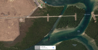
Have a look here . . .
Google maps
1.2km to Santiago, and almost directly via Dorothy H Stirling (low tide sat image), the DHT is a couple of hundred metres back on the opposite side of the river, big mangrove tree grows through it.
That take off spot (long time development) was accessible last time I was down there, hopefully still ok when I get back there.
It's elevated, so the flight could be kept quite low, signal should be no issue.
It'd be the furthest I would have flown, previously 1km very remote desert region.
If it goes down, then at least it'd be in the river and no harm done on the ground.
I've driven around looking for other access points, none.
..You can still walk out to the first wreck from the road, there's just a fence you have to duck around at the top,
Other option is if the racing club is open, just ask someone if you can park up and have a fly, I'm sure they wouldn't mind.
Yep, that's the little track, it used to be much clearer, then they stuck a fence there, can still get down there though, I did a few weeks back, but it was high tide, so no where clear to launch from. Interesting how they stick a fence there to keep a few people a week out, but they have no problem clearing and bulldozing half the rest of the island behind there for whatever reason...
This little track / old cleared access through the mangrove ?
A good spot and keeping reasonably high, I found signal is good for those old barge wrecks nearby.
Thought about speedboat club, would likely be 200m closer. and although good LOS / VLOS, it's right at river level, so not sure about VLOS for long, even with strobes.
The elevated point in map link (post 16) is probably around 80m - 90m higher ground.
Looking a the map again I wonder if that Club Road is accessible further, say down to HERE . . .
Down to ~ 700m flight distance each way from there.
Might be worth a call and see if permission could be gained (though I was thinking dawn or sunset flight).
Yep, that's the little track, it used to be much clearer, then they stuck a fence there, can still get down there though, I did a few weeks back, but it was high tide, so no where clear to launch from.
Other option is a kayak
I've been looking for an excuse to buy one for years.


We use essential cookies to make this site work, and optional cookies to enhance your experience.