DJI Mavic, Air and Mini Drones
Friendly, Helpful & Knowledgeable Community
Join Us Now

Should a Mavic 2 Be Off by 8 to 11 Feet for Waypoint Missions and Altitude?

jelarv

Well-Known Member
Joined
May 30, 2020
Messages
71
Reactions
16
Location
Kildeer, IL
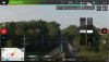
I've flow a waypoint mission about 5 times over the past week and tonight when I flew it, my M2 was about 8-10 feet too far to the left. The left photo below is what it looked like a few days ago when following the route and the right photo is what occurred twice this evening using the same waypoint mission. Between the attempts this evening I calibrated the compass and earlier today I calibrated the IMU. Is this the margin of error I need to accept with the M2 or is there something wrong (I've owned it for only about 6 weeks)?

Somewhat related, about 30 minutes earlier when I did a short flight and came back the altitude when landing was -11 feet even though it landed in the same place it took off. Any help you can provide is greatly appreciated because if there's going to be 8-11 feet margin of error on each mission, it's somewhat pointless.
Same Mission Two Routes.jpg
 

Attachments

  • 1593828606564.png
    1593828606564.png
    2.2 MB · Views: 22
Perfectly normal I would say. You are looking at consumer-grade GPS performance. The error is in meters.
Same for the altitude info. It's mainly provided by the baronmeter. If the atmospheric pressure has changed over time, the baronmeter will provide a wrong reading. In this flight my M2P showed an altitude of +3.1 meters when landing at the take off point :

 
Somewhat related, about 30 minutes earlier when I did a short flight and came back the altitude when landing was -11 feet even though it landed in the same place it took off.
Any help you can provide is greatly appreciated because if there's going to be 8-11 feet margin of error on each mission, it's somewhat pointless.
You're depending on consumer GPS and seem unaware of it's accuracy limitations.
If you assumed it was pinpoint accurate, you were incorrect.
Read here for details:
Flying waypoint missions with only a small margin for error is asking for trouble and you need to factor in a suitable safety margin.
Recalibrating the compass and IMU won't make any difference to GPS.
 
  • Wow
Reactions: jelarv
Perfectly normal I would say. You are looking at consumer-grade GPS performance. The error is in meters.
Same for the altitude info. It's mainly provided by the baronmeter. If the atmospheric pressure has changed over time, the baronmeter will provide a wrong reading. In this flight my M2P showed an altitude of +3.1 meters when landing at the take off point :

Thanks for your feedback. Do you know of a make and model of drone that would produce a more accurate result?
 
Thanks for your feedback. Do you know of a make and model of drone that would produce a more accurate result?
Nav GPS is around 3-5 metres horizontal. The only way to improve that is e.g. Phantom 4 RTK. That uses an associated dedicated base station or network GPS correction signal to derive accuracies on the drone at around 50mm, sometimes better. My colleagues use one in NZ, in our land surveying project work. Waypoint planning is in DJI; post processing imagery is in Pix4d. The hardware cost is serious: around $NZ12K. Processing is extra ...... ?????
 
Nav GPS is around 3-5 metres horizontal. The only way to improve that is e.g. Phantom 4 RTK. That uses an associated dedicated base station or network GPS correction signal to derive accuracies on the drone at around 50mm, sometimes better. My colleagues use one in NZ, in our land surveying project work. Waypoint planning is in DJI; post processing imagery is in Pix4d. The hardware cost is serious: around $NZ12K. Processing is extra ...... ?????
Thanks David! You and the other MP's have been very helpful. I did some research and it looks like the RTK isn't as reliable as PPK because RTK requires more connectivity. I can't find a DJI drone that has PPK. I stumbled across this accessory for the M2: For DJI Mavic 2 Pro
 
I believe it's the limitation of Satellite GPS signal. Years ago (when I got my first garmin) it was said that GPS would direct you to the parking lot. Eventually the US Govt relaxed the rules on GPS, and the new accuracy would "get you to your car". And for Hikers, mountaineers, etc. that's plenty good enough. Try using any garmin device & you'll get the same.

I think it's pretty darn spectacular that these devices are even this accurate for the price. If you need ultra precision flying, just learn to be a better pilot. It takes practice & skill, which I certainly haven't achieved yet. But it can be done. One test a friend told me about is to learn to sly a corkscrew pattern up & around a flagpole. Look on youtube and you'll see amazing precision flying. I too wish waypoints could be more accurate, but I'm impressed with what I have. The next step -for me at least- is to be a better pilot AND videographer. And where's the challenge if you just press a few buttons?
Thanks Citizen. I'm not trying "be a better pilot" because I'm too old to rely any longer on quick instant reflexes, which is why I was excited about creating waypoint missions where I could do all the work in advance. After spending about 2-3 hours creating one that went around every obstacle along about a 2 mile of railroad right-of-way, I've now discovered it's a complete waste of time because the drone could be 10 feet in a different direction/altitude which would put it into trees or power lines. It's my fault for not understanding the limitations of the drone before I purchased it. Given what I've learned I'm looking at getting a PPK drone which apparently had precision within a few centimeters.
 
I’m probably older than you but less fatalistic.

Technology + expectations = reality.

Beethoven composed while DEAF in his later years. Cowboy up & just figure it out! There’s always a way...
 
  • Like
Reactions: jelarv
Thanks Citizen. I'm not trying "be a better pilot" because I'm too old to rely any longer on quick instant reflexes, which is why I was excited about creating waypoint missions where I could do all the work in advance. After spending about 2-3 hours creating one that went around every obstacle along about a 2 mile of railroad right-of-way, I've now discovered it's a complete waste of time because the drone could be 10 feet in a different direction/altitude which would put it into trees or power lines. It's my fault for not understanding the limitations of the drone before I purchased it. Given what I've learned I'm looking at getting a PPK drone which apparently had precision within a few centimeters.


You might want to reconsider the entire mission, as it's probably not very safe or legal to be flying 16 feet over railroad tracks 2 miles away from your location. Not only is that outside your visual line of sight, but train cars can be around 14 feet tall themselves, so that's not much of a margin of error.
 
You might want to reconsider the entire mission, as it's probably not very safe or legal to be flying 16 feet over railroad tracks 2 miles away from your location. Not only is that outside your visual line of sight, but train cars can be around 14 feet tall themselves, so that's not much of a margin of error.
Thanks dawgpilot! I'm flying 1 mile in each direction with a church steeple visible to the north and a bridge to the south. The tallest standard rail car in North America is a double-stack intermodal which is 21' 3" and so flying at 26' leaves plenty of clearance if the altitude on the drone is accurate (which mine is not). The challenge is telephone and power lines are often in the 26'-30' range which is why the right-of-way needs to be thoroughly researched before conducting a mission. Railroads control their right-of-way and easements (oddly enough, if a automobile is hit by a train, the RRs consider it "trespassing") but they can't control drones flying over their property unless there is voyeurism or violation of other drone laws. I avoid trespassing on their property by standing on private property.
 
The tallest standard rail car in North America is a double-stack intermodal which is 21' 3" and so flying at 26' leaves plenty of clearance if the altitude on the drone is accurate (which mine is not).
That's fine is the rail line is perfectly flat.
Your altitude is relative to the launch point.
If there was a uniform 1:100 grade, there would be a 53 ft height difference from one end to the other over 1 mile.
Throw in some wires and trees close by to one side or the other and there are too many risks.

If you are a new flyer, you might be getting too adventurous, too early and not realising the real risks in the flight you're planning.
 
  • Like
Reactions: pelagic_one
Thanks Meta4! I've been using the ground level at each waypoint to compute the drone's required altitude relative to the take off point...one more reason why it's taken me a few hours to build the mission (I've even gone out and measured specific obstacles). While it's worked perfect a few times, I realized in my original post above, when it starts off with the wrong GPS or altitude, the entire mission is wrong. That's why I need a more accurate drone.
 
Just wondering ........ Couldn’t you just add the 10ft of uncertainty to each of your waypoints? You could also fly it multiple times to average out the errors and pick the best footage.
 
Just wondering ........ Couldn’t you just add the 10ft of uncertainty to each of your waypoints? You could also fly it multiple times to average out the errors and pick the best footage.
I could do some of your suggestion, but along the railroad right-of-way there are places where tree branches protrude out 5 to 10 feet up at 30-40 feet above ground level and so the only way to be 100% certain of no problems would be to fly above the trees which puts me 70' to 80' AGL. It's quite a different experience than being at 26'-35' AGL (which is 5' to 14' above the moving train). Here's a video that has about 30 seconds with the higher option and then switches to the lower one: Train Footage.mp4
 
  • Like
Reactions: Camino Ken
For info, you need to have RTK (real-time kinematics) if you want to have a better position while flying, i.e. that the drone can use to correct its position while flying. PPK (post-process kinematics) is used to "post-process" the position, i.e. you fly and then you can use other sources of data as well as the recorded data to find out more exactly where you flew it (by doing some math stuff after the flight). This can not be used to correct flying position while flying, but might help if you are for example measuring/collecting data and you need to find out exactly where you flew.

Also, note that it is not easy to mount some extra RTK-module onto an existing drone as you need to make sure that it actually uses the data from that module. Most of the time, getting a better "source" (i.e. RTK vs standard GPS) might require the internal control loops to be re-tuned.

So my best hint for you, if you need the drone to fly more accurately, is to upgrade to one of the existing RTK solutions out there.
Thanks Stefan! Your insights are incredibly helpful. I've read the problem with RTK is that it's easy to get disconnected from the ground station which would then make any effort to upgrade my equipment a pointless exercise. Are you familiar enough with the technology to clarify this point? I'm wondering if RTK is primarily for mapping in open areas or those close to ground stations, thus suggesting my goal to have a drone that can be incredibly accurate when obstacles such as trees are present is unrealistic.
 
Thanks Stefan! Your insights are incredibly helpful. I've read the problem with RTK is that it's easy to get disconnected from the ground station which would then make any effort to upgrade my equipment a pointless exercise. Are you familiar enough with the technology to clarify this point? I'm wondering if RTK is primarily for mapping in open areas or those close to ground stations, thus suggesting my goal to have a drone that can be incredibly accurate when obstacles such as trees are present is unrealistic.
Glad you found it informative. :) Yes, with RTK you need to have a "base" (RTK terminology) station. This is transmitting "correction data", i.e. it sends all data it can see to the "rover". The "rover" (in RTK terminology) is the moving antenna and does the calculations to get RTK fix. The "rover" usually looks like a "2m high post with a 19cm RTK antenna on top" that the people doing surveying have with them.
I have used both systems with a "local base" (using radio to transmit from the local base to the rover) as well as system based on 3G correction data (normally a paid service). In this case, you do not need a local base as the data is coming from a company (through 3G/4G network) that has a lot of bases spread out over the area they cover. Hence, you need 3G/4G coverage for this to work.

The RTK can usually survive with a "fix" even if the base data is missing for a few seconds (not minutes), but if using a local base (that I think the DJI RTK is using) you cannot fly without radio range of the base in order to keep the RTK position. It will then most likely fall back on standard GPS (if it works like the systems I have used).
 
Thanks to all on this thread. I was “way pointing” a drive up my drive way (1/4 mile) through the woods up to our clearing. I would ”fly program“ the waypoints in both DJI GO 4 and Litchi and when I ran them at slow speed, so I could follow at 3mph, each one had variations on the run that put the drone into tree branches (I stopped the program accordingly) that were about 10 feet away from the original fly-programmed path. sounds like the issue is based on the GPS issues as described (I fly Mavic Pro). It looks like I will need to learn to fly the route better using Cinematic mode and repeat it each season (want to have drive ups in each season). Best to all and thanks
 
Lycus Tech Mavic Air 3 Case

DJI Drone Deals

New Threads

Forum statistics

Threads
131,092
Messages
1,559,743
Members
160,076
Latest member
Mini2boost