DJI Mavic, Air and Mini Drones
Friendly, Helpful & Knowledgeable Community
Join Us Now

Single app/point of contact for Seeking Approval to Fly Drones

dj3183

Active Member
Joined
Feb 6, 2022
Messages
27
Reactions
18
Age
70
Location
Las Vegas
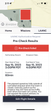
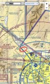
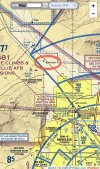
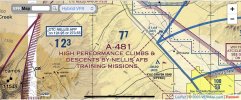
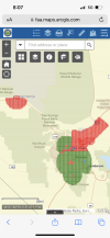
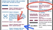
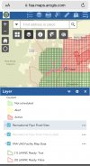
I would like to ask a question to the group. Why is there no single source where a UAS pilot can input their flight parameters and get immediate feedback of whether or not it’s permissible to fly, and if not permissible, immediately send you to a form where you can apply for an FAA waiver? I feel that this is the FAA’s responsibility to provide such a site for UAS pilots. In some cases, I’ve found that the B4UFLY app contradicts FAA Sectional Charts. I even went to the Aloft app, put in my flight parameters (for a flight at 3PM), and it came back and said that the responsible control tower I was not open during that time when I knew it was. In my opinion, the FAA should be required to develop and maintain such a app if it wants UAS pilots to comply with their regulations. In recent email conversation with the FAA, their representative sent me to some obscure site (http://faa.maps.arcgis.com/) where it’s not clear where to go when you get there. If the FAA wants us to comply with their regulations, then they need to make the effort to make it easier and less confusing for us UAS pilots.

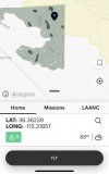
So, where do you go before you fly? Where do you go to get approval when necessary?
 

Attachments

  • IMG_0225.jpeg
    IMG_0225.jpeg
    206 KB · Views: 12
  • IMG_0223.png
    IMG_0223.png
    721.2 KB · Views: 12
  • IMG_0220.jpeg
    IMG_0220.jpeg
    1.1 MB · Views: 12
  • IMG_0219.jpeg
    IMG_0219.jpeg
    1,022.7 KB · Views: 12
  • IMG_0221.jpeg
    IMG_0221.jpeg
    854.5 KB · Views: 10
  • IMG_0226.png
    IMG_0226.png
    974.6 KB · Views: 11
  • IMG_0227.jpeg
    IMG_0227.jpeg
    386.5 KB · Views: 12
It's all there and it's straightforward and simple.
  • Use the FAA's B4YouFly app to check federal regulations.
  • Use Aloft or one of the other FAA-approved LAANC providers to get authorization to fly in controlled airspace.
The UAS Facilities Map at http://faa.maps.arcgis.com/ is a convenient way to locate controlled airspace throughout the country where LAANC services are available. Nothing obscure about it.

What's the conflict between the sectional and B4YouFly that you see? (The controlled airspace where you put the red circles has a floor at 6500' MSL.)
 
According to the legend in the sectional charts (picture provided), it is also an MOA. It is also within a dotted magenta line which would, in light of the fact that there is a comment over that section that says, “See NOTAMs/Supplement for Class D/E (sfc) eff hours” which one might think that it is then in class E airspace and, if starting at surface, would require a waiver/approval from the FAA.

Regarding the http://faa.maps.arcgis.com/, it takes you to the below page. What are you supposed to click on then? Not very clear, is it? What’s ADDS? What’s UDDS? And once you find the page with all of the little red and green hashmarks, they don’t explain much. When you finally figure out that you have to go to “Layers” to read the map, it’s very confusing.

My only point is this. Why isn’t there one place where you can go, where ANY UAS pilot can go, and simply click on where they want to takeoff, what their intended path is, what their altitude will be, and their hours of operation. Seems pretty simple to me. And as an extension to that, if after inputting all of this information, it determines that you need some sort of a waiver, send you to (or provide a link to) a form which can be submitted to the FAA for approval. Simple as that.
 

Attachments

  • IMG_0257.jpeg
    IMG_0257.jpeg
    322.3 KB · Views: 4
  • IMG_0258.jpeg
    IMG_0258.jpeg
    445.9 KB · Views: 4
Regarding the http://faa.maps.arcgis.com/, it takes you to the below page. What are you supposed to click on then? Not very clear, is it? What’s ADDS? What’s UDDS? And once you find the page with all of the little red and green hashmarks, they don’t explain much. When you finally figure out that you have to go to “Layers” to read the map, it’s very confusing.
This link might be easier for you.


As for all the little red and green marks, the indicate whether LAANC authorization is available at the particular location. Red - NO. Green - YES. The numbers in each grid block indicate the maximum altitude available for auto approval.

EDIT: The forum software hides all the characters of that URL after the basic link, so that link looks just like the previously posted link. Here's the full address of the UAS Facility Map page. I had to add a couple of spaces after the https:// to avoid the auto formatting. If you cut and paste it, remove the two spaces.

https:// faa.maps.arcgis.com/apps/webappviewer/index.html?id=9c2e4406710048e19806ebf6a06754ad
 
Last edited:
This link might be easier for you.


As for all the little red and green marks, the indicate whether LAANC authorization is available at the particular location. Red - NO. Green - YES. The numbers in each grid block indicate the maximum altitude available for auto approval.

So, why isn’t there an app explaining all this or giving every one who wants to fly a drone a place to go to (like B4UFLY) so they can determine whether it’s safe to fly? Do you really think that Rec pilots know about this web page that you referenced?

So, are you saying that this web page that you referenced is the only place that any of us need to check before flying and if I’m not in either a red or green checkered zone, that it’s completely legal and safe to fly to 400 feet? If so, why isn’t the FAA telling everyone about this web page? We are all having to register our drones. That would certainly be a good opportunity for the FAA to disseminate that kind of information, don’t you think? I certainly never saw any reference to this webpage in any of my Part 107 training manuals.

Looking further into the link that you gave me, I clicked on one of the quadrants that had a 400 in it and this (see attached) is all that came up. Doesn’t say anything about having to apply for approval. According to your response, I would need to submit for a LAANC waiver. Where does it say that? And, if approval is needed, why doesn’t any of this say where I need to go for approval.

Listen, I appreciate everything you’re telling me and I am learning a lot. But, my point is this. Why isn’t there an intuitive and easy to use app for all of us UAS users to go to for everything? For determining if allowed to fly, and for submitting for waivers. In my opinion, the FAA must take responsibility in providing that if they want all of us to adhere to their rules.
 

Attachments

  • IMG_0259.jpeg
    IMG_0259.jpeg
    300.9 KB · Views: 5
So, are you saying that this web page that you referenced is the only place that any of us need to check before flying and if I’m not in either a red or green checkered zone, that it’s completely legal and safe to fly to 400 feet?
No, absolutely not.

Here's a video that explains the LAANC authorization process. I can't help with your other questions.

 
Not to be obtuse or condescending, but pilots for crewed aviation do not have one application to research and file a flight plan. We as remote pilots have the responsibility to educate ourselves about the airspace that we share with all other aircraft. While our aircraft may seem like a toy with their size and ease of operation, the FAA and Congress do not consider them a toy. It is our responsibility to learn and obey the rules that govern our hobby/business.

Even if you remain a recreational pilot, studying for the §107 exam is a very useful thing to do. It will explain all the questions you have asked and then some. It will make you a safer and more informed pilot.
 
air control has everything thats needed,so whats the point of using b4yfly?
 
  • Like
Reactions: DoomMeister
Lycus Tech Mavic Air 3 Case

DJI Drone Deals

New Threads

Members online

Forum statistics

Threads
131,129
Messages
1,560,126
Members
160,100
Latest member
PilotOne