DJI Mavic, Air and Mini Drones
Friendly, Helpful & Knowledgeable Community
Join Us Now

Software for Video"grammetry"

Argos2023

Member
Joined
Feb 20, 2023
Messages
9
Reactions
16
Age
29
Location
Germany
Hey there, I'm curious if there is some software for some kind of Videogrammetry. Result should be an ortho, Improvement should be lower mission time than flying waypoint stop and start missions

I know i can stich Video with ICE but that is not working out too well. Any Ideas ?

Best
 
If you are talking about photogrammetry, Pix4d is popular
 
Not really clear what you're actually looking for here. It is entirely possible to extract the info from video footage to use in mapping and 3d terrain models by extracting frame-grabs from the video files. In the example in the thread linked below I used video files as the input data for the model generation - some of the same footage used in the video. I did use some still images for the surface texturing as they were clearer and sharper that the framegrabs.

 
Pretty close to what i'am looking for.

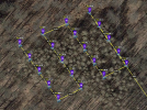
Let me explain. My normal Mapping Mission is a start and stop Waypoint mission. just like this:
1677185036488.png

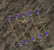
And at every Waypoint the Drone stops, takes a Photo and starts to the next WP again. rather than that i Would like to have a Mission like this:

1677185159413.png

Which would basicly be start Video and Cam down -90° at WP 2, turn at the corner Waypoints, Stop Video at WP 11.

The aim is o stich it to an Ortho.

I know i can take pictures from the Video like every 2 seconds/frames or whatever. But can i also get the EXIF Data for the frames ?

This would speed up the process of collecting Data a lot. Especially if you don't really need great GSD's etc.


Best
 
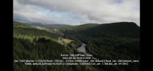
What specific information would you want to get from exif data? If you record "subtitles" with the video you get a separate ".srt" file with basic info for every frame of video. Here's a typical example of the info recorded displayed as subtitles overlaid onto the video. The text won't appear in the frames extracted. It would also require a bit of work to extract the relevant data fields and import that into your mapping software.
 

Attachments

  • Screenshot_20230223_210557_File Manager +.jpg
    Screenshot_20230223_210557_File Manager +.jpg
    660.2 KB · Views: 5
Last edited:
  • Like
Reactions: TrabSeyn
If you're looking to be rid of the drone stopping for each photo you probably need to look at MapPilotPro or DroneLink. They will fly at a continuous speed during the sweeps (unless you select the option to stop). Mapping with Litchi while possible the feature just hasn't matured, though it may in the future. By using video, not counting the work to extract the frames, your GSD is going to drop from the lower resolution and the compression applied. This will require more sweeps at a lower altitude to extract the same amount of pixels to feed into your stitching software. Even then you'll wind up with a lower quality map (video compression) for a lot more time/work involved.

The least expensive method with the least amount of hassle is the MME/MPP workflow. Not free but much cheaper than DroneDeploy after their significant price increase last summer. DroneLink will let you fly faster, as some "upgrade" to MPP limited the max speed by model of drone but this is only an advantage if you're mapping a couple hundred acres. MPP is the less expensive option and will get the job done just fine. Invest in an extra battery or two and you'll be good to go. If you are just doing this for "recreational" purposes you can get Dronelink ($99) and WebODM ($60) and be free of paying for processing for MME. The MME pay as you go option is still a little lighter on the wallet as long as you're only flying a handful of maps per month. The price is well worth the time savings.
 
  • Like
Reactions: scro and maggior
Lycus Tech Mavic Air 3 Case

DJI Drone Deals

New Threads

Forum statistics

Threads
130,959
Messages
1,558,348
Members
159,959
Latest member
zzombie