DJI Mavic, Air and Mini Drones
Friendly, Helpful & Knowledgeable Community
Join Us Now

Speed for max flight distance?

Flying at a constant speed of 28.8 kph in a windless environment at sea level, with APAS off, AirSense off, camera parameters set to 1080p/24fps, video mode off, and from 100% battery level until 0%.​


This looks like a quote, and yet the Air 3 does not have AirSense. Would you mind linking where this came from?
 
I know i am old (65) and my eyes aint what they used to be but for me 22Km (13+miles) is clearly BVLOS.
To play devil's advocate momentarily, a drone flying a localized and repetitive "lawn-mower" flight plan to generate photograph sequences for mapping projects could cover 22 miles while remaining within visual line of sight. DJI recognizes that the growth of the drone mapping industry will increase demand for drones capable of progressively longer flight times to accommodate large-scale mapping projects with a minimum of battery change interruptions.

In jurisdictions where securing official permission to launch long drone flights could best be described as straightforward in contrast to the stringent regimes enforced by the FAA and CAA in their airspace, one can probe the ragged edge of the round trip distance attainable by various DJI drones as they range out over 6 country miles from home base and cover up to 13 miles round-trip on a single battery charge.

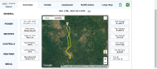
My venerable Mavic 1 Pro, retrofitted with an Ali Express after-market extra-range "hunchback" battery, covered just over 11 miles round-trip during this flight that traversed mile upon mile of oil palm plantation, and twice circled a point of interest 5 miles away during which time I adjusted the camera gimbal pitch thumb-wheel from my Mission Control vantage point comprising a wooden bench located atop a 60-foot water tower.

1728711466977.png


The Air 3 caught my attention because of the rave reviews it has earned since its release as a "Poor Man's Mavic 3", but it was that demonstrably attainable battery life of 40 minutes powered by a sleek stock battery that caught my eye, along with the fact that the Air 3 fulfills a vital requirement that any drone I launch on a Litchi waypoint mission MUST be capable of and configured to continue following its pre-defined waypoint sequence to complete that circle back to base for a manual landing even if signal connectivity with the controller is lost for any reason.

As I scan eBay in search of a good deal on a used DJI Air 3 drone with the lowly RC-N2 (no-screen) controller to use with my iPad Mini, I would like to seek the opinion of long-term owners of Air 3 drones who frequent this forum what their recommendations for airspeed setting might be to maximize the round trip distance attainable with an Air 3 flying an autonomous waypoint mission, with all power-consuming obstacle avoidance and landing assist features disabled.

In the Air Data drone flight record of a Litchi waypoint mission flown by my old Mavic 1 Pro, a flight time of 28 minutes elapsed during which the drone covered 11 miles at 27mph before landing with a nail-biting 14% battery time remaining. Extrapolating this data to the DJI Air 3 whose actual observed battery life cruising in "N" Mode is 40 minutes, the Air 3 should be capable of traversing well over TWENTY miles round trip, as a conservative estimate.

In conclusion, this new Air 3 devotee, set to become an Air 3 owner very soon, is all ears to learn from the gurus who have mastered the nuances of this diamond in the rough - The Air 3. How far can your Air 3 fly, be that in mapping grid patterns, or meandering cross-country waypoint missions as your regional laws permit?
 
Last edited:
The Air 3 caught my attention because of the rave reviews it has earned since its release as a "Poor Man's Mavic 3", but it was that demonstrably attainable battery life of 40 minutes powered by a sleek stock battery that caught my eye, along with the fact that the Air 3 fulfills a vital requirement that any drone I launch on a Litchi waypoint mission MUST be capable of and configured to continue following its pre-defined waypoint sequence to complete that circle back to base for a manual landing even if signal connectivity with the controller is lost for any reason.
Are you sure that the Air 3 would work with Litchi?
The Litchi website doesn't suggest this for Litchi or Litchi Pilot.

Even if it did, it would probably be via Virtual Sticks and only run waypoint missions as long as it has signal.
The Air 3. How far can your Air 3 fly, be that in mapping grid patterns, or meandering cross-country waypoint missions as your regional laws permit?
If you fly a lawnmower grid, the drone would be constantly slowing to almost a stop for corners and accelerating, slowing, accelerating etc for the whole mission.
With all that slowing and speeding up the Max Distance and Max Flight Time would be significantly less than the distance and time shown in the specs.
 
Wes Barris the code meister who has generously made available for free thus far several Litchi utilities, also offers a superb waypoint mission conversion feature that has been tested and does work according to respondents in the Litchi forum. This waypoint converter enables Litchi users to convert their existing waypoint missions saved in the Litchi Mission Hub, into DJI format waypoint flight plans that can be uploaded to DJI Fly, and saved for later execution within DJI Fly.


Were it not for the waypoint mission converter that Mr. Barris created, I would not be in the market to buy a DJI Air 3 because I have read enough gripes from drone operators about DJI's native waypoint feature's cumbersome user interface to decide that I would prefer to continue planning all my future waypoint flights with Litchi, until the cows come home, as it were. I currently own several Mavic1 Pros and Mavic 2 Pros, yet my addictive compulsion remains unabated, to buy just one additional newer, improved, and more versatile DJI drone that can also fly autonomously beyond signal range like the older, Litchi-compliant classics from the Phantoms to the Mavic 2 Pro.

DJI's waypoint creator does offer pre-set camera gimbal angle control variations beyond signal range, along with pre-defined camera image magnification zoom assignments as saved variables before takeoff and departure to execute pre-programmed waypoint flight plans, but I am not aware as to whether Litchi waypoint missions that have been converted to DJI waypoint mission format can be edited after that conversion to include camera gimbal pitch and zoom settings. If preset adjustments of those highly desirable variables can be controlled in DJI Fly waypoint files that were initially converted from Litchi format I will be in hog heaven the day I take delivery of my first-ever DJI Air3.

Finally, I agree that flying a grid pattern for mapping would consume battery power at a higher rate than a waypoint mission crafted with smooth gradual airliner turns that can be taken at cruise speed without slowing down. I look forward to hearing from Air 3 owners in this forum who fly long waypoint missions since their battery consumption findings will be a closer approximation of what I can expect, perhaps with ambient temperatures as the primary variable capable of impacting battery longevity between charges.
 
Last edited:
I forgot to mention that the Air 3, like the Mavic 3 family, is capable of storing all waypoint GPS data on board before takeoff on waypoint missions, which enables them to continue following predefined waypoint sequences even in the event of a discontinuity or outright loss in RC controller signal communication with the drone.

I bought my Mini 3 under the mistaken presumption that it would benefit from a DJI official SDK so that Litchi could work its magic without restraints, but, I was wrong, so now I only fly the ( Virtual Stiocks) Mini 3 on rare occasions to keep the batteries alive till I can find a buyer for that barely used and hastily bought paper-weight.
 
I bought my Mini 3 under the mistaken presumption that it would benefit from a DJI official SDK so that Litchi could work its magic without restraints, but, I was wrong, so now I only fly the ( Virtual Stiocks) Mini 3 on rare occasions to keep the batteries alive till I can find a buyer for that barely used and hastily bought paper-weight.
DJI hasn't released an SDK that would allow Litchi to work with an Air 3 (or Mavic 3), so you might be out of luck there.
 
Last edited:
It does look like the Mini 3 will wind up as one of DJI's forgotten orphans haha. That said, I have seen a couple of YouTube videos showing that a Mini 3 is now compatible with Drone Link for mapping purposes, so I shouldn't have too much difficulty finding a buyer for the Mini 3.

I usually keep and use my older DJI drones because my poor eyesight means I am just as impressed with footage filmed with a Phantom 3 Standard, as I am with recordings made by the Mini 3 whose camera is several drone generations newer than those of my aging fleet of museum piece DJI drones. Besides, I think I might be a drone hoarder haha.
 
Were it not for the waypoint mission converter that Mr. Barris created, I would not be in the market to buy a DJI Air 3 because I have read enough gripes from drone operators about DJI's native waypoint feature's cumbersome user interface

In my opinion this is very short-sighted. It's just another user interface, a matter of learning.

And it's not that bad. It's just more cumbersome to implement certain features. I certainly wouldn't miss out on the other quite valuable features of the A3 or Mini 4 Pro (the long flight times being a biggie) just because I had to learn a new way to construct a waypoint mission.
 
It does look like the Mini 3 will wind up as one of DJI's forgotten orphans haha. That said, I have seen a couple of YouTube videos showing that a Mini 3 is now compatible with Drone Link for mapping purposes, so I shouldn't have too much difficulty finding a buyer for the Mini 3.

I usually keep and use my older DJI drones because my poor eyesight means I am just as impressed with footage filmed with a Phantom 3 Standard, as I am with recordings made by the Mini 3 whose camera is several drone generations newer than those of my aging fleet of museum piece DJI drones. Besides, I think I might be a drone hoarder haha.

Bought an M4P shortly after it was released, moved a year ago, can't find my Mini3P 🤣

Its here somewhere, without a doubt in a box in the garage. This has been the most lazy move ever, @62 I have a lot less energy. Half the garage is still packed with boxes we're slowly working through... I hate moving 🤬
 
The upside of packing a house full of personal effects is that you find a few long misplaced documents or possessions you'd written off as lost, Every house cleaning is akin to an archeological dig for me haha.

For an absent-minded old DJI drone collector like me, remembering to periodically charge up and use batteries back down to 50% before it is too late can become a forgotten chore. I've had to bin a handful of DJI drone batteries that took a charge when I set them aside but were neglected just a bit too long until they no longer showed any signs of life.
 
I had several flights now with my Air 3 and I always documented a lot of data. All flights were done manually. I should try waypoints for a more constant speed.
My results are between 274 and 300 m/%. Remember: DJI says the optimum for the Air 3 could be 320 m/%. I reached my optimum at an average speed of 48 km/h. But I was recording in 4K/60 and didn't turn off other things. I think obstacle avoidance is turned off in sport mode. I am also flying at a little higher elevations and not in a flat environment. So I think 300 m/% is pretty good.
 
This reply is appreciated Papa Echo. Would I be correct in speculating that the units denoted as "m/%" refer to mAh of battery charge capacity consumed as a function of each unit of percentage battery charge capacity consumed?

In other words, is it correct to say that 300 m/% means that for every 1% of battery power consumed during the drone's flight, the battery charge level was also recorded to have depleted by 300mAh?
No, it doesn't have anything to do with mAh, because we don't have the data from the Air 3. It's only the % of battery used. When I take off with 100% battery and land with 25% and I know that I have flown a round trip of 22.5 km then I have an average of 300 m/%. Then I need the time I was flying (including take off and landing) and I divide the km through the time flown. That's the speed.
Maybe if I skip the take off and the last 15 seconds before landing I could be close to the 320 m/%. Let me check that later.
 
Ah, I see. I better understand this method of analyzing battery longevity with the explanation you've kindly given. The distance of 22.5Km (13+ miles) traveled round trip by your Air 3 to leave a 25% landing battery charge level is respectable battery life considering that the flight was piloted manually at variable speed, assuming the cruise control feature was not selected for those test flights.

It will be instructive to see how much those battery consumption rates improve when the flights are fully automated with nice gradual turns and perhaps with obstacle avoidance disabled to conserve battery power. This reply adds more data points defining the performance envelope of the Air 3 in a manner that is repeatable by drone pilots worldwide.
 
I have recalculated the flight with the best m/% (so far 300 m/%) with the following "adjustments":
The start is 100 m after take off when the battery goes from 100% to 99%.
The end is 750 m before landing.
Then I reach 305.2 m/% with an average speed of 48.5 km/h.

I didn't use cruise control, because you can't change the altitude while you are cruising. But I have to gain altitude in my terrain although I always stay very low to the ground.
 
With appreciation for these shared Air 3 battery life findings, Papa Echo, I am copying this data into my growing file of conventional wisdom that will minimize trial-and-error when my new-to-me Air 3 arrives and gets reincarnated as a long-range automonous waypoint mission platform that will give my fleet of older DJI drones a run for their money.
 

DJI Drone Deals

New Threads

Forum statistics

Threads
135,144
Messages
1,602,958
Members
163,637
Latest member
trisen1981
Want to Remove this Ad? Simply login or create a free account