The b4ufly app clearly shows the town as *between* the airspace of several airports. The bubbles shown on the map dont cover the town or areas I want to fly so Im not sure why you keep repeating that. I am definitely a newb so correct me please if im reading the map wrong.
Great, you're checking maps, you're using the b4ufly app (I saw no indication of that in your post, apologies if I missed that), that's all good, that's important. So kudos to you and thank you for that.
That said, details of the location do matter. In your post, you said "a farm" and "Southampton." I'm guessing (it's been years since I was there) that there probably aren't many large farms right within the town itself (the built-up, "urban" area) of Southampton, but there definitely are some
outside of town, north, east and west of there. So the specific location matters - 2 miles east or 3 miles west of the town center, you would be in the Class Delta.
So, right in the downtown? No problem from the FAA (assuming you're not flying over other people, a separate issue). A few miles east or west...then you gotta look more closely at your specific location.
I know you're new to this (I've read your other posts). Don't be afraid, but you do want to learn the rules (please take the TRUST test and get your drone registered, nothing to fear from that).
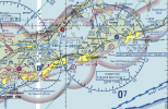
Keep in mind, you are in an area with some moderately complex airspace - see below for a portion of the local aeronautical chart (not as bad as a bit further west...the entire NY City metro area is pretty complex, of course).
The areas in "solid yellow" on this kind of chart depicts built-up areas (areas that at night, would appear "lit up" by ground lights to airplane pilots). You can see that the built-up area depicted for "Southampton" sprawls a bit. Note that how it's depicted here is not a political or jurisdictional boundary, it's just how the area would appear at night to someone flying over. But you can see, the eastern edge of "Southampton" gets pretty close to the Class Delta for East Hampton Town airport (less than a mile). North of town, not so much. West of town...look out if you cross that bridge at Hampton Bays, the airspace for FOK (Gabreski) starts just past it.

So for the airspace issues (FAA regulated) it would be pretty clear: you should be good to go, as long as you stay outside the Class Delta airspace (depicted by the dashed, dark-blue circles around Gabreski and East Hampton Town airports, typically a 5-mile radius around the airport). Do keep an eye out for low flying aircraft and maintain awareness (also note that heliport out on the beach south of town).
There are no regulations laws against taking pictures of farmland (or much else) from above (other than simple privacy concerns, usually just common-sense stuff). On a nice day, there will be a lot of small aircraft traffic around here.
As I said above, there MAY be
local regulations limiting where you can
takeoff or land a drone. Given the "fame and fortune" of more than a few Southampton residents, I would not be shocked if there was some local regulations restricting that (takeoffs and landings). Google is your friend (try something like "[town name] + drone + regulations" and parse what comes up). If you find nothing prohibiting takeoff or landings of drones from roads and other public property, go have fun. Do try to keep a low profile, but be reasonable, friendly if approached, do your best to respect others, common sense stuff.
Just curious if it is common policy to forbid launching from a car parked on the grass on the side of a street for example to at least get the view from the street. And then how to go about figuring out if it is a nogo to fly over the farmland itself
I don't know how common it is, but such regulations definitely do exist in some places. In others there may be few or no restrictions. The "Southampton" crowd includes plenty of wealthy NYC people with their lawyers, and that's not a helicopter I would want to run my drone into. As long as you know the regs, you know your location, and you are in the clear for that, don't let anyone bully you.
The farmland's owner generally has no right to stop overflight (same as airplanes), though some may not like it. Try to be on your best behavior, as you would hope any visitor to your own home would be.
One last item: do check for TFRs (temporary flight restrictions). These can pop up unexpectedly when there's a major event, disaster or VIP visit (often confused with a disaster...). It's campaign season, and when major political figures visit, TFRs often precede them. It sucks to live in a state with a hotly contested, high-profile election looming, you get too many TFRs as politicians come to raise money (lotta money to be raised in the Hamptons, I'd guess).
Here's a good website you can use to check for TFRs:
FAA Graphical TFRs
Good luck.


