DJI Mavic, Air and Mini Drones
Friendly, Helpful & Knowledgeable Community
Join Us Now

Test Prep: Charts and airspace example that has me puzzled

pchaps

Well-Known Member
Joined
Apr 24, 2022
Messages
132
Reactions
40
Age
48
Location
USA
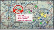
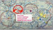
In the attached chart detail, please see the red circle that I drew. I undertand that to each side, there are shaded magenta circles indicating Class E airspace from 700' AGL up to bottom of airspace above, here that would be the bottom of Class A. However, in this video that I'm watching, the narrator (with a great voice by the way) says, if I heard him right, that the space in-between (see my bold red circle) is Class E from 1200' AGL upward. It's Class E inside my red circle?

Can you help me understand how the in-between areas are Class E 1200' and upward? I thought that in-between areas, outside the shaded magenta circles were Class G. Thanks!
1-question-Class-E-1200.jpg
 
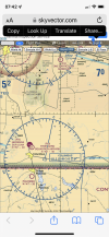
Most of CONUS has Class E starting at 1200’ AGL. If you look at the Legend on the sectional charts you will find a shaded blue (like the shaded magenta) that denotes Class E at 1200’ AGL. It pretty much encompasses the 48 contiguous states. As seen here along the US/Mexico border (along with the red checkered ADIZ). 9161D8C9-8468-4613-AE64-0DE3AEFA065C.png
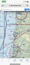
Along the west coast of the US you will find the blue zipper line with 1200’ AGL marked on the side toward the coast.
A5D4ECF9-C34B-4AB1-B38B-BDF3F46F8258.png
 
  • Like
Reactions: pchaps
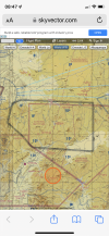
This is one of the rare areas in the contiguous US where Class E starts at 14,500’ MSL. Note that the darker edge of the shaded blue is toward the inside of the polygon. The faded side means Class E starts at 1200’ AGL. Of course there is not a lot of difference when you take in the elevation figures of 9^7, 10^1, and 10^6.
EC266CB4-54C1-4DE9-B734-E03338474336.png
 
  • Like
Reactions: pchaps and Ty Pilot
Great examples. Thank you. Very helpful. I see that in the last example, that the terrain elevations are interesting as there at least one 10K ft. mountain peak. Makes sense that E would start above that :) [one light bulb going on lol] I’ve done extensive photography along the banks of the Rio Grande, flying with a retired Border Patrol pilot. I will now look at where he expertly flew the backcountry and National Park — albeit now I will study the sectional charts myself. It should be interesting with this new perspective of training for Part 107.
 
1651694852368.jpeg
Hello, pchaps. I've read your post with interest, but I'm not sure what you mean by "Class E inside my red circle."

I annotated your attachment with some numbered points to give examples. Keep in mind that the FAA has broken Class E airspace into eight different types.

1. If you are standing on the ground at Point 1, you are in Class G airspace. Class E5 directly above you starts at 1200 ft. AGL.

2. If you are standing at Point 2, you are in Class E2 (dashed magenta line) which starts at the surface, meaning you are prohibited from flying there without an authorization.

3. If you are standing at Point 3, you are in Class G airspace. Class E5 directly above you starts at 700 ft. AGL.

4. If you are standing at Point 4, you are in Class E4 airspace. This is Class E airspace area designated as an extension to a Class D or Class E surface area. You can fly here, but only up to 400 ft. AGL with caution due to the Restricted Area R-5303 immediately to the southeast of Point 4. The airspace directly above you is Class E5 starting at 1200 ft. AGL.

5. If you are standing at Point 5, you are in Class D (dashed blue line) which begins at the surface meaning you can't fly there unless you can get LAANC authorization. In fact, the entire Class D airspace area for New River MCAS has a LAANC grid and you could get authorization at a lot of locations in that busy airspace.
Link: ArcGIS Web Application

Here's a link to an FAA document that you may find helpful: https://www.faa.gov/uas/resources/e.../How_To_Understand_and_Operate_in_Class_E.pdf

Here is the current list of Class E types:
E1 - Class E airspace at and above 14,000 feet MSL.
E2 - Class E airspace areas designated as a surface area for an airport.
E3 - Class E airspace areas designated as an extension to a Class C surface area.
E4 - Class E airspace areas designated as an extension to a Class D or Class E surface area.
E5 - Class E airspace areas extending upward from 700 feet or more above the surface of the earth.
E6 - Enroute domestic airspace areas.
E7 - Offshore airspace areas.
E8 - Class E airspace areas designated as federal airways.

The only Class E type that FAA Part 107 drone operators have to be concerned about is Class E2 (14 CFR Sec. 107.41)

Best regards,
 

Attachments

Last edited:
View attachment 147753
Hello, pchaps. I've read your post with interest, but I'm not sure what you mean by "Class E inside my red circle."

I annotated your attachment with some numbered points to give examples. Keep in mind that the FAA has broken Class E airspace into eight different types.

1. If you are standing on the ground at Point 1, you are in Class G airspace. Class E5 directly above you starts at 1200 ft. AGL.

2. If you are standing at Point 2, you are in Class E2 (dashed magenta line) which starts at the surface, meaning you are prohibited from flying there without an authorization.

3. If you are standing at Point 3, you are in Class G airspace. Class E5 directly above you starts at 700 ft. AGL.

4. If you are standing at Point 4, you are in Class E4 airspace. This is Class E airspace area designated as an extension to a Class D or Class E surface area. You can fly here, but only up to 400 ft. AGL with caution due to the Restricted Area R-5303 immediately to the southeast of Point 4. The airspace directly above you is Class E5 starting at 1200 ft. AGL.

5. If you are standing at Point 5, you are in Class D (dashed blue line) which begins at the surface meaning you can't fly there.

Here's a link to an FAA document that you may find helpful: https://www.faa.gov/uas/resources/e.../How_To_Understand_and_Operate_in_Class_E.pdf

Here is the current list of Class E types:
E1 - Class E airspace at and above 14,000 feet MSL.
E2 - Class E airspace areas designated as a surface area for an airport.
E3 - Class E airspace areas designated as an extension to a Class C surface area.
E4 - Class E airspace areas designated as an extension to a Class D or Class E surface area.
E5 - Class E airspace areas extending upward from 700 feet or more above the surface of the earth.
E6 - Enroute domestic airspace areas.
E7 - Offshore airspace areas.
E8 - Class E airspace areas designated as federal airways.

The only Class E type that FAA Part 107 drone operators have to be concerned about is Class E2 (14 CFR Sec. 107.41)

Best regards,
Thank you for taking the time to annotate the chart that I posted. I am just now starting to get a clearer overview of airspaces. Even your first comment immediately lit another bulb for me: "1. If you are standing on the ground at Point 1, you are in Class G airspace. Class E5 directly above you starts at 1200 ft. AGL." THAT makes perfect sense to me!

Then, the explanation and examples of airspace extensions (where there is/isn't a separating line) astonished me with helpful insight. Thats for sharing that, and the memo! Great material and teaching--I appreciate this more than words can express!

Also I watched the Airspaces using Minecraft video on uTube and loved that 3D modeling. I would like to see more of that type of illustration. Some people show shaded cylinders, etc as airspace volumes, but to model it in MineCraft, or 3D modeling, be able to fly around it, and then enter into the airspace was brilliant. Even better if someone did this from a ground lauch sUAV perspective, and even showing an antenna inspective job in which the +400ft allowance pierced another controlled airspace above. Given the sophisticated animations being done with advanced users on PC's and Macs's I can imagine that such simulations will become even more real and dramatic!

ps: about that Class E statement in my original post, it was a statement in a youtube video that made little sense to me. In fact, being overtired, I labeled the chart more correctly :) You clarified all that it in your "1." response succinctly. Your writing rapidly puts this in perspestive in the most usable way. Superb!
 
Most of CONUS has Class E starting at 1200’ AGL. If you look at the Legend on the sectional charts you will find a shaded blue (like the shaded magenta) that denotes Class E at 1200’ AGL. It pretty much encompasses the 48 contiguous states. As seen here along the US/Mexico border (along with the red checkered ADIZ). View attachment 147738
Along the west coast of the US you will find the blue zipper line with 1200’ AGL marked on the side toward the coast.
Oh the border the shaded blue plus the speckled zone indicates both Class E starting at 1200' -and- ADZ, respectively? Did I get that right?
 
Oh the border the shaded blue plus the speckled zone indicates both Class E starting at 1200' -and- ADZ, respectively? Did I get that right?
Yes, as you see on our southern border with Mexico. The red speckled line is Air Defense Identification Zone (ADIZ) and the shaded blue on the faded side is Class E at 1200’ AGL.
 

DJI Drone Deals

New Threads

Forum statistics

Threads
134,485
Messages
1,595,523
Members
163,013
Latest member
GLobus55
Want to Remove this Ad? Simply login or create a free account