Hey all,
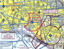
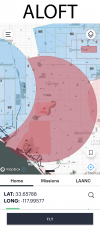
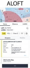
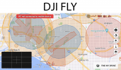
Hoping that the more experienced amongst you might be able to help me clarify an issue. I live in Southern California, near Los Alamitos Army Airfield (KSLI). Where I live is class G (uncontrolled) airspace, but according to Aloft a large portion of the airspace surrounding where I live falls within Los Alamitos Army Airfield's class D airspace. Ordinarily this wouldn't be a problem as I do have my part 107 and can generally get LAANC approval. Unfortunately this is an army airfield and they don't participate in LAANC. Additionally my understanding is that military bases either outright reject any attempt at receiving clearance through Drone Zone, or just don't respond, effectively rejecting them. I've looked at the sectional charts of the area, and to me it appears that the inner circle of class D has a floor of 6000ft and a ceiling of 10000ft. Typically the inner circle airspace I've seen around airports extends to the surface, which is what is throwing me in this case. Am I reading this wrong? DJI Fly has a much less restrictive geofence of controlled airspace (as it often does), so actually launching the drone wouldn't be an issue, but I'd like to make sure I'm doing things legally. If in fact this class D does extend to the surface, and they reject any attempts at obtaining clearance, is this in effect just a permanent no fly zone? Any help would be greatly appreciated.
Hoping that the more experienced amongst you might be able to help me clarify an issue. I live in Southern California, near Los Alamitos Army Airfield (KSLI). Where I live is class G (uncontrolled) airspace, but according to Aloft a large portion of the airspace surrounding where I live falls within Los Alamitos Army Airfield's class D airspace. Ordinarily this wouldn't be a problem as I do have my part 107 and can generally get LAANC approval. Unfortunately this is an army airfield and they don't participate in LAANC. Additionally my understanding is that military bases either outright reject any attempt at receiving clearance through Drone Zone, or just don't respond, effectively rejecting them. I've looked at the sectional charts of the area, and to me it appears that the inner circle of class D has a floor of 6000ft and a ceiling of 10000ft. Typically the inner circle airspace I've seen around airports extends to the surface, which is what is throwing me in this case. Am I reading this wrong? DJI Fly has a much less restrictive geofence of controlled airspace (as it often does), so actually launching the drone wouldn't be an issue, but I'd like to make sure I'm doing things legally. If in fact this class D does extend to the surface, and they reject any attempts at obtaining clearance, is this in effect just a permanent no fly zone? Any help would be greatly appreciated.